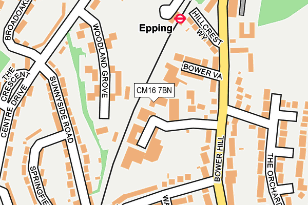
CM16 7BN lies on Bower Hill Industrial Estate in Epping. CM16 7BN is located in the Epping Hemnall electoral ward, within the local authority district of Epping Forest and the English Parliamentary constituency of Epping Forest. The Sub Integrated Care Board (ICB) Location is NHS Hertfordshire and West Essex ICB - 07H and the police force is Essex. This postcode has been in use since August 1993.


GetTheData
Source: OS OpenMap – Local (Ordnance Survey)
Source: OS VectorMap District (Ordnance Survey)
Licence: Open Government Licence (requires attribution)
| Easting | 546166 |
| Northing | 201383 |
| Latitude | 51.692180 |
| Longitude | 0.113333 |
GetTheData
Source: Open Postcode Geo
Licence: Open Government Licence
| Street | Bower Hill Industrial Estate |
| Town/City | Epping |
| Country | England |
| Postcode District | CM16 |
➜ See where CM16 is on a map ➜ Where is Epping? | |
GetTheData
Source: Land Registry Price Paid Data
Licence: Open Government Licence
Elevation or altitude of CM16 7BN as distance above sea level:
| Metres | Feet | |
|---|---|---|
| Elevation | 70m | 230ft |
Elevation is measured from the approximate centre of the postcode, to the nearest point on an OS contour line from OS Terrain 50, which has contour spacing of ten vertical metres.
➜ How high above sea level am I? Find the elevation of your current position using your device's GPS.
GetTheData
Source: Open Postcode Elevation
Licence: Open Government Licence
| Ward | Epping Hemnall |
| Constituency | Epping Forest |
GetTheData
Source: ONS Postcode Database
Licence: Open Government Licence
| The Orchards (Bower Hill) | Epping | 122m |
| The Orchards (Bower Hill) | Epping | 144m |
| Railway Station (Station Yard) | Epping | 173m |
| Sunnyside Road (Centre Drive) | Epping | 239m |
| Sunnyside Road (Centre Drive) | Epping | 251m |
| Epping Underground Station | Epping | 170m |
GetTheData
Source: NaPTAN
Licence: Open Government Licence
Estimated total energy consumption in CM16 7BN by fuel type, 2015.
| Consumption (kWh) | 36,244 |
|---|---|
| Meter count | 6 |
| Mean (kWh/meter) | 6,041 |
| Median (kWh/meter) | 2,389 |
GetTheData
Source: Postcode level gas estimates: 2015 (experimental)
Source: Postcode level electricity estimates: 2015 (experimental)
Licence: Open Government Licence
GetTheData
Source: ONS Postcode Database
Licence: Open Government Licence


➜ Get more ratings from the Food Standards Agency
GetTheData
Source: Food Standards Agency
Licence: FSA terms & conditions
| Last Collection | |||
|---|---|---|---|
| Location | Mon-Fri | Sat | Distance |
| Centre Drive | 18:00 | 11:45 | 341m |
| Railway Station | 18:00 | 11:45 | 357m |
| Allnuts Road | 17:20 | 11:45 | 364m |
GetTheData
Source: Dracos
Licence: Creative Commons Attribution-ShareAlike
The below table lists the International Territorial Level (ITL) codes (formerly Nomenclature of Territorial Units for Statistics (NUTS) codes) and Local Administrative Units (LAU) codes for CM16 7BN:
| ITL 1 Code | Name |
|---|---|
| TLH | East |
| ITL 2 Code | Name |
| TLH3 | Essex |
| ITL 3 Code | Name |
| TLH35 | West Essex |
| LAU 1 Code | Name |
| E07000072 | Epping Forest |
GetTheData
Source: ONS Postcode Directory
Licence: Open Government Licence
The below table lists the Census Output Area (OA), Lower Layer Super Output Area (LSOA), and Middle Layer Super Output Area (MSOA) for CM16 7BN:
| Code | Name | |
|---|---|---|
| OA | E00110516 | |
| LSOA | E01021757 | Epping Forest 006B |
| MSOA | E02004532 | Epping Forest 006 |
GetTheData
Source: ONS Postcode Directory
Licence: Open Government Licence
| CM16 7AS | Bower Vale | 97m |
| CM16 7AD | Bower Hill | 113m |
| CM16 7AP | Bower Terrace | 118m |
| CM16 4NF | Woodland Grove | 134m |
| CM16 4NE | Woodland Grove | 152m |
| CM16 7AR | Hillcrest Way | 156m |
| CM16 4NG | Woodland Grove | 169m |
| CM16 7AL | Bower Hill | 173m |
| CM16 7AU | Charles Street | 176m |
| CM16 7AA | Bower Hill | 198m |
GetTheData
Source: Open Postcode Geo; Land Registry Price Paid Data
Licence: Open Government Licence