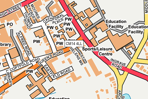
CM14 4LL lies on St Helens Mews in Brentwood. CM14 4LL is located in the Brentwood South electoral ward, within the local authority district of Brentwood and the English Parliamentary constituency of Brentwood and Ongar. The Sub Integrated Care Board (ICB) Location is NHS Mid and South Essex ICB - 99E and the police force is Essex. This postcode has been in use since August 2010.


GetTheData
Source: OS OpenMap – Local (Ordnance Survey)
Source: OS VectorMap District (Ordnance Survey)
Licence: Open Government Licence (requires attribution)
| Easting | 559786 |
| Northing | 193652 |
| Latitude | 51.619016 |
| Longitude | 0.306691 |
GetTheData
Source: Open Postcode Geo
Licence: Open Government Licence
| Street | St Helens Mews |
| Town/City | Brentwood |
| Country | England |
| Postcode District | CM14 |
➜ See where CM14 is on a map ➜ Where is Brentwood? | |
GetTheData
Source: Land Registry Price Paid Data
Licence: Open Government Licence
Elevation or altitude of CM14 4LL as distance above sea level:
| Metres | Feet | |
|---|---|---|
| Elevation | 100m | 328ft |
Elevation is measured from the approximate centre of the postcode, to the nearest point on an OS contour line from OS Terrain 50, which has contour spacing of ten vertical metres.
➜ How high above sea level am I? Find the elevation of your current position using your device's GPS.
GetTheData
Source: Open Postcode Elevation
Licence: Open Government Licence
| Ward | Brentwood South |
| Constituency | Brentwood And Ongar |
GetTheData
Source: ONS Postcode Database
Licence: Open Government Licence
| Queen's Road (A128) | Brentwood | 100m |
| Council Offices (Ingrave Road) | Brentwood | 134m |
| Council Offices (Ingrave Road) | Brentwood | 147m |
| Ursuline High School (Queens Road) | Brentwood | 156m |
| Wilsons Corner (Ingrave Road) | Brentwood | 204m |
| Brentwood Station | 0.8km |
| Shenfield Station | 2.1km |
GetTheData
Source: NaPTAN
Licence: Open Government Licence
| Percentage of properties with Next Generation Access | 100.0% |
| Percentage of properties with Superfast Broadband | 100.0% |
| Percentage of properties with Ultrafast Broadband | 0.0% |
| Percentage of properties with Full Fibre Broadband | 0.0% |
Superfast Broadband is between 30Mbps and 300Mbps
Ultrafast Broadband is > 300Mbps
| Percentage of properties unable to receive 2Mbps | 0.0% |
| Percentage of properties unable to receive 5Mbps | 0.0% |
| Percentage of properties unable to receive 10Mbps | 0.0% |
| Percentage of properties unable to receive 30Mbps | 0.0% |
GetTheData
Source: Ofcom
Licence: Ofcom Terms of Use (requires attribution)
GetTheData
Source: ONS Postcode Database
Licence: Open Government Licence


➜ Get more ratings from the Food Standards Agency
GetTheData
Source: Food Standards Agency
Licence: FSA terms & conditions
| Last Collection | |||
|---|---|---|---|
| Location | Mon-Fri | Sat | Distance |
| Crown Street | 17:30 | 09:00 | 375m |
| Brentwood Post Office | 18:30 | 12:30 | 423m |
| North Road | 17:15 | 08:15 | 513m |
GetTheData
Source: Dracos
Licence: Creative Commons Attribution-ShareAlike
The below table lists the International Territorial Level (ITL) codes (formerly Nomenclature of Territorial Units for Statistics (NUTS) codes) and Local Administrative Units (LAU) codes for CM14 4LL:
| ITL 1 Code | Name |
|---|---|
| TLH | East |
| ITL 2 Code | Name |
| TLH3 | Essex |
| ITL 3 Code | Name |
| TLH36 | Heart of Essex |
| LAU 1 Code | Name |
| E07000068 | Brentwood |
GetTheData
Source: ONS Postcode Directory
Licence: Open Government Licence
The below table lists the Census Output Area (OA), Lower Layer Super Output Area (LSOA), and Middle Layer Super Output Area (MSOA) for CM14 4LL:
| Code | Name | |
|---|---|---|
| OA | E00108901 | |
| LSOA | E01021436 | Brentwood 007B |
| MSOA | E02004470 | Brentwood 007 |
GetTheData
Source: ONS Postcode Directory
Licence: Open Government Licence
| CM14 4LS | St Helens Mews | 34m |
| CM14 4SJ | St Helens Mews | 54m |
| CM14 4EY | Queens Road | 56m |
| CM14 4RD | St Helens Mews | 96m |
| CM14 4DF | St Thomas Road | 103m |
| CM14 4GX | Eastfield Road | 111m |
| CM14 4HF | Eastfield Road | 114m |
| CM14 4RF | St Helens Mews | 121m |
| CM14 4HB | Eastfield Road | 124m |
| CM15 8TG | Ingrave Road | 178m |
GetTheData
Source: Open Postcode Geo; Land Registry Price Paid Data
Licence: Open Government Licence