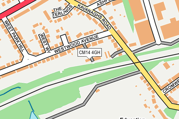
CM14 4GH is located in the Brentwood West electoral ward, within the local authority district of Brentwood and the English Parliamentary constituency of Brentwood and Ongar. The Sub Integrated Care Board (ICB) Location is NHS Mid and South Essex ICB - 99E and the police force is Essex. This postcode has been in use since July 2017.


GetTheData
Source: OS OpenMap – Local (Ordnance Survey)
Source: OS VectorMap District (Ordnance Survey)
Licence: Open Government Licence (requires attribution)
| Easting | 558498 |
| Northing | 192985 |
| Latitude | 51.613387 |
| Longitude | 0.287801 |
GetTheData
Source: Open Postcode Geo
Licence: Open Government Licence
| Country | England |
| Postcode District | CM14 |
➜ See where CM14 is on a map ➜ Where is Brentwood? | |
GetTheData
Source: Land Registry Price Paid Data
Licence: Open Government Licence
| Ward | Brentwood West |
| Constituency | Brentwood And Ongar |
GetTheData
Source: ONS Postcode Database
Licence: Open Government Licence
2021 12 MAR £585,000 |
7, BURNTWOOD WAY, BRENTWOOD, CM14 4GH 2018 31 OCT £550,000 |
2018 17 MAY £537,000 |
1, BURNTWOOD WAY, BRENTWOOD, CM14 4GH 2017 27 NOV £570,000 |
2015 24 NOV £825,000 |
1999 28 JUL £220,000 |
GetTheData
Source: HM Land Registry Price Paid Data
Licence: Contains HM Land Registry data © Crown copyright and database right 2025. This data is licensed under the Open Government Licence v3.0.
| Kavanaghs Road (London Road) | Brentwood | 281m |
| Kavanaghs Road (London Road) | Brentwood | 288m |
| Clements Park School (Vaughan Williams Way) | Warley | 370m |
| Bt Building (London Road) | Brentwood | 448m |
| Crescent Road (Vaughan Williams Way) | Brentwood | 466m |
| Brentwood Station | 0.8km |
| Shenfield Station | 3.5km |
| Harold Wood Station | 4.4km |
GetTheData
Source: NaPTAN
Licence: Open Government Licence
| Percentage of properties with Next Generation Access | 100.0% |
| Percentage of properties with Superfast Broadband | 100.0% |
| Percentage of properties with Ultrafast Broadband | 0.0% |
| Percentage of properties with Full Fibre Broadband | 0.0% |
Superfast Broadband is between 30Mbps and 300Mbps
Ultrafast Broadband is > 300Mbps
| Median download speed | 48.0Mbps |
| Average download speed | 44.3Mbps |
| Maximum download speed | 60.30Mbps |
| Median upload speed | 10.3Mbps |
| Average upload speed | 10.1Mbps |
| Maximum upload speed | 14.07Mbps |
| Percentage of properties unable to receive 2Mbps | 0.0% |
| Percentage of properties unable to receive 5Mbps | 0.0% |
| Percentage of properties unable to receive 10Mbps | 0.0% |
| Percentage of properties unable to receive 30Mbps | 0.0% |
GetTheData
Source: Ofcom
Licence: Ofcom Terms of Use (requires attribution)
GetTheData
Source: ONS Postcode Database
Licence: Open Government Licence


➜ Get more ratings from the Food Standards Agency
GetTheData
Source: Food Standards Agency
Licence: FSA terms & conditions
| Last Collection | |||
|---|---|---|---|
| Location | Mon-Fri | Sat | Distance |
| Kavanaghs Road | 17:00 | 11:30 | 87m |
| Hill Road | 17:15 | 09:00 | 426m |
| Hillside Walk | 17:30 | 09:45 | 505m |
GetTheData
Source: Dracos
Licence: Creative Commons Attribution-ShareAlike
The below table lists the International Territorial Level (ITL) codes (formerly Nomenclature of Territorial Units for Statistics (NUTS) codes) and Local Administrative Units (LAU) codes for CM14 4GH:
| ITL 1 Code | Name |
|---|---|
| TLH | East |
| ITL 2 Code | Name |
| TLH3 | Essex |
| ITL 3 Code | Name |
| TLH36 | Heart of Essex |
| LAU 1 Code | Name |
| E07000068 | Brentwood |
GetTheData
Source: ONS Postcode Directory
Licence: Open Government Licence
The below table lists the Census Output Area (OA), Lower Layer Super Output Area (LSOA), and Middle Layer Super Output Area (MSOA) for CM14 4GH:
| Code | Name | |
|---|---|---|
| OA | E00108914 | |
| LSOA | E01021438 | Brentwood 006A |
| MSOA | E02004469 | Brentwood 006 |
GetTheData
Source: ONS Postcode Directory
Licence: Open Government Licence
| CM14 4PA | Westwood Avenue | 86m |
| CM14 4NQ | Kavanaghs Road | 90m |
| CM14 4NE | Kavanaghs Road | 123m |
| CM14 4PD | Manor Way | 127m |
| CM14 4NF | Kavanaghs Terrace | 138m |
| CM14 4NB | Kavanaghs Road | 141m |
| CM14 4NG | The Terlings | 173m |
| CM14 4JY | Hubert Road | 193m |
| CM14 5JA | Hospital Cottages | 199m |
| CM14 4PB | West Way | 204m |
GetTheData
Source: Open Postcode Geo; Land Registry Price Paid Data
Licence: Open Government Licence