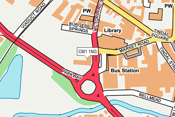
CM1 1NG is located in the Moulsham and Central electoral ward, within the local authority district of Chelmsford and the English Parliamentary constituency of Chelmsford. The Sub Integrated Care Board (ICB) Location is NHS Mid and South Essex ICB - 06Q and the police force is Essex. This postcode has been in use since December 1996.


GetTheData
Source: OS OpenMap – Local (Ordnance Survey)
Source: OS VectorMap District (Ordnance Survey)
Licence: Open Government Licence (requires attribution)
| Easting | 570582 |
| Northing | 206803 |
| Latitude | 51.733981 |
| Longitude | 0.468876 |
GetTheData
Source: Open Postcode Geo
Licence: Open Government Licence
| Country | England |
| Postcode District | CM1 |
➜ See where CM1 is on a map ➜ Where is Chelmsford? | |
GetTheData
Source: Land Registry Price Paid Data
Licence: Open Government Licence
Elevation or altitude of CM1 1NG as distance above sea level:
| Metres | Feet | |
|---|---|---|
| Elevation | 30m | 98ft |
Elevation is measured from the approximate centre of the postcode, to the nearest point on an OS contour line from OS Terrain 50, which has contour spacing of ten vertical metres.
➜ How high above sea level am I? Find the elevation of your current position using your device's GPS.
GetTheData
Source: Open Postcode Elevation
Licence: Open Government Licence
| Ward | Moulsham And Central |
| Constituency | Chelmsford |
GetTheData
Source: ONS Postcode Database
Licence: Open Government Licence
| Victoria Road South | Chelmsford City Centre | 45m |
| Retail Market (Market Road) | Chelmsford City Centre | 55m |
| Retail Market (Market Road) | Chelmsford City Centre | 59m |
| Careers Office (Duke Street) | Chelmsford City Centre | 207m |
| Cathedral (Duke Street) | Chelmsford City Centre | 209m |
| Chelmsford Station | 0.3km |
GetTheData
Source: NaPTAN
Licence: Open Government Licence
GetTheData
Source: ONS Postcode Database
Licence: Open Government Licence


➜ Get more ratings from the Food Standards Agency
GetTheData
Source: Food Standards Agency
Licence: FSA terms & conditions
| Last Collection | |||
|---|---|---|---|
| Location | Mon-Fri | Sat | Distance |
| Cm1 442 Exchange Way (Old Branch Office) | 17:30 | 13:15 | 210m |
| Branch Office | 17:30 | 13:15 | 210m |
| Essex Distribution Centre | 17:30 | 12:15 | 211m |
GetTheData
Source: Dracos
Licence: Creative Commons Attribution-ShareAlike
| Risk of CM1 1NG flooding from rivers and sea | Low |
| ➜ CM1 1NG flood map | |
GetTheData
Source: Open Flood Risk by Postcode
Licence: Open Government Licence
The below table lists the International Territorial Level (ITL) codes (formerly Nomenclature of Territorial Units for Statistics (NUTS) codes) and Local Administrative Units (LAU) codes for CM1 1NG:
| ITL 1 Code | Name |
|---|---|
| TLH | East |
| ITL 2 Code | Name |
| TLH3 | Essex |
| ITL 3 Code | Name |
| TLH36 | Heart of Essex |
| LAU 1 Code | Name |
| E07000070 | Chelmsford |
GetTheData
Source: ONS Postcode Directory
Licence: Open Government Licence
The below table lists the Census Output Area (OA), Lower Layer Super Output Area (LSOA), and Middle Layer Super Output Area (MSOA) for CM1 1NG:
| Code | Name | |
|---|---|---|
| OA | E00109624 | |
| LSOA | E01033141 | Chelmsford 010G |
| MSOA | E02004494 | Chelmsford 010 |
GetTheData
Source: ONS Postcode Directory
Licence: Open Government Licence
| CM1 1HU | Cannon Mews | 127m |
| CM1 1LN | Victoria Road South | 141m |
| CM1 1JP | Duke Street | 186m |
| CM1 1LW | Duke Street | 207m |
| CM1 1HW | Burgess Springs | 208m |
| CM1 1UP | Duke Street | 214m |
| CM1 1HL | Duke Street | 215m |
| CM1 1EH | Tindal Square | 259m |
| CM1 1GS | Marconi Plaza | 261m |
| CM1 1NX | Cathedral Walk | 264m |
GetTheData
Source: Open Postcode Geo; Land Registry Price Paid Data
Licence: Open Government Licence