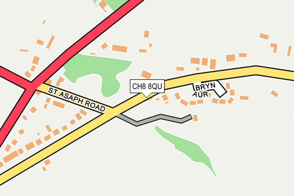
CH8 8QU is in Gorsedd, Holywell. CH8 8QU is located in the Whitford electoral ward, within the unitary authority of Flintshire and the Welsh Parliamentary constituency of Delyn. The Local Health Board is Betsi Cadwaladr University and the police force is North Wales. This postcode has been in use since January 1980.


GetTheData
Source: OS OpenMap – Local (Ordnance Survey)
Source: OS VectorMap District (Ordnance Survey)
Licence: Open Government Licence (requires attribution)
| Easting | 314679 |
| Northing | 376590 |
| Latitude | 53.279396 |
| Longitude | -3.281082 |
GetTheData
Source: Open Postcode Geo
Licence: Open Government Licence
| Locality | Gorsedd |
| Town/City | Holywell |
| Country | Wales |
| Postcode District | CH8 |
➜ See where CH8 is on a map ➜ Where is Gorsedd? | |
GetTheData
Source: Land Registry Price Paid Data
Licence: Open Government Licence
Elevation or altitude of CH8 8QU as distance above sea level:
| Metres | Feet | |
|---|---|---|
| Elevation | 210m | 689ft |
Elevation is measured from the approximate centre of the postcode, to the nearest point on an OS contour line from OS Terrain 50, which has contour spacing of ten vertical metres.
➜ How high above sea level am I? Find the elevation of your current position using your device's GPS.
GetTheData
Source: Open Postcode Elevation
Licence: Open Government Licence
| Ward | Whitford |
| Constituency | Delyn |
GetTheData
Source: ONS Postcode Database
Licence: Open Government Licence
1 - 2, OLD ROCK COTTAGES, GORSEDD, HOLYWELL, CH8 8QU 2018 9 MAR £295,000 |
GetTheData
Source: HM Land Registry Price Paid Data
Licence: Contains HM Land Registry data © Crown copyright and database right 2025. This data is licensed under the Open Government Licence v3.0.
| Rock Inn (St Asaph Road) | Lloc | 201m |
| Gorsedd Farm (Gorsedd Road) | Gorsedd | 269m |
| Gorsedd Farm (Gorsedd Road) | Gorsedd | 271m |
| Druid Inn (Gorsedd Road) | Gorsedd | 603m |
| Druid Inn (Gorsedd Road) | Gorsedd | 608m |
GetTheData
Source: NaPTAN
Licence: Open Government Licence
GetTheData
Source: ONS Postcode Database
Licence: Open Government Licence


➜ Get more ratings from the Food Standards Agency
GetTheData
Source: Food Standards Agency
Licence: FSA terms & conditions
| Last Collection | |||
|---|---|---|---|
| Location | Mon-Fri | Sat | Distance |
| Ffordd Asaph | 09:00 | 09:00 | 1,975m |
| Penrallt | 11:00 | 11:00 | 2,831m |
| Mostyn Post Office | 16:30 | 10:00 | 3,456m |
GetTheData
Source: Dracos
Licence: Creative Commons Attribution-ShareAlike
The below table lists the International Territorial Level (ITL) codes (formerly Nomenclature of Territorial Units for Statistics (NUTS) codes) and Local Administrative Units (LAU) codes for CH8 8QU:
| ITL 1 Code | Name |
|---|---|
| TLL | Wales |
| ITL 2 Code | Name |
| TLL2 | East Wales |
| ITL 3 Code | Name |
| TLL23 | Flintshire and Wrexham |
| LAU 1 Code | Name |
| W06000005 | Flintshire |
GetTheData
Source: ONS Postcode Directory
Licence: Open Government Licence
The below table lists the Census Output Area (OA), Lower Layer Super Output Area (LSOA), and Middle Layer Super Output Area (MSOA) for CH8 8QU:
| Code | Name | |
|---|---|---|
| OA | W00001824 | |
| LSOA | W01000340 | Flintshire 002C |
| MSOA | W02000059 | Flintshire 002 |
GetTheData
Source: ONS Postcode Directory
Licence: Open Government Licence
| CH8 8RA | Bryn Aur | 122m |
| CH8 8RD | St Asaph Road | 138m |
| CH8 8QX | Pant Y Wacco | 243m |
| CH8 8QZ | 359m | |
| CH8 8RB | Babell Road | 571m |
| CH8 8QA | Osprey Court | 601m |
| CH8 8RP | Parc Gorsedd | 673m |
| CH8 8QY | 686m | |
| CH8 8RW | Top Y Lloc Lane | 800m |
| CH8 8RG | 871m |
GetTheData
Source: Open Postcode Geo; Land Registry Price Paid Data
Licence: Open Government Licence