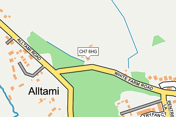
CH7 6HG lies on White Farm Road in Alltami, Mold. CH7 6HG is located in the Buckley: Mountain electoral ward, within the unitary authority of Flintshire and the Welsh Parliamentary constituency of Alyn and Deeside. The Local Health Board is Betsi Cadwaladr University and the police force is North Wales. This postcode has been in use since December 1999.


GetTheData
Source: OS OpenMap – Local (Ordnance Survey)
Source: OS VectorMap District (Ordnance Survey)
Licence: Open Government Licence (requires attribution)
| Easting | 327217 |
| Northing | 365248 |
| Latitude | 53.179351 |
| Longitude | -3.090487 |
GetTheData
Source: Open Postcode Geo
Licence: Open Government Licence
| Street | White Farm Road |
| Locality | Alltami |
| Town/City | Mold |
| Country | Wales |
| Postcode District | CH7 |
➜ See where CH7 is on a map ➜ Where is Alltami? | |
GetTheData
Source: Land Registry Price Paid Data
Licence: Open Government Licence
Elevation or altitude of CH7 6HG as distance above sea level:
| Metres | Feet | |
|---|---|---|
| Elevation | 140m | 459ft |
Elevation is measured from the approximate centre of the postcode, to the nearest point on an OS contour line from OS Terrain 50, which has contour spacing of ten vertical metres.
➜ How high above sea level am I? Find the elevation of your current position using your device's GPS.
GetTheData
Source: Open Postcode Elevation
Licence: Open Government Licence
| Ward | Buckley: Mountain |
| Constituency | Alyn And Deeside |
GetTheData
Source: ONS Postcode Database
Licence: Open Government Licence
| Sunningdale (Aberllanerch Drive) | Buckley | 666m |
| Field Farm Road (St Mellor`s Road) | Buckley | 710m |
| St Andrew`s Drive | Buckley | 974m |
| Belmont Crescent (Liverpool Road) | Buckley | 1,001m |
| Belmont Crescent (Liverpool Road) | Buckley | 1,007m |
| Buckley Station | 2.9km |
| Hawarden Station | 4km |
| Penyffordd Station | 4.7km |
GetTheData
Source: NaPTAN
Licence: Open Government Licence
| Percentage of properties with Next Generation Access | 100.0% |
| Percentage of properties with Superfast Broadband | 100.0% |
| Percentage of properties with Ultrafast Broadband | 50.0% |
| Percentage of properties with Full Fibre Broadband | 0.0% |
Superfast Broadband is between 30Mbps and 300Mbps
Ultrafast Broadband is > 300Mbps
| Percentage of properties unable to receive 2Mbps | 0.0% |
| Percentage of properties unable to receive 5Mbps | 0.0% |
| Percentage of properties unable to receive 10Mbps | 0.0% |
| Percentage of properties unable to receive 30Mbps | 0.0% |
GetTheData
Source: Ofcom
Licence: Ofcom Terms of Use (requires attribution)
GetTheData
Source: ONS Postcode Database
Licence: Open Government Licence


➜ Get more ratings from the Food Standards Agency
GetTheData
Source: Food Standards Agency
Licence: FSA terms & conditions
| Last Collection | |||
|---|---|---|---|
| Location | Mon-Fri | Sat | Distance |
| Lower Common | 16:00 | 11:00 | 523m |
| Alltami | 17:10 | 08:00 | 649m |
| Liverpool Road Post Office | 16:00 | 11:00 | 975m |
GetTheData
Source: Dracos
Licence: Creative Commons Attribution-ShareAlike
The below table lists the International Territorial Level (ITL) codes (formerly Nomenclature of Territorial Units for Statistics (NUTS) codes) and Local Administrative Units (LAU) codes for CH7 6HG:
| ITL 1 Code | Name |
|---|---|
| TLL | Wales |
| ITL 2 Code | Name |
| TLL2 | East Wales |
| ITL 3 Code | Name |
| TLL23 | Flintshire and Wrexham |
| LAU 1 Code | Name |
| W06000005 | Flintshire |
GetTheData
Source: ONS Postcode Directory
Licence: Open Government Licence
The below table lists the Census Output Area (OA), Lower Layer Super Output Area (LSOA), and Middle Layer Super Output Area (MSOA) for CH7 6HG:
| Code | Name | |
|---|---|---|
| OA | W00001425 | |
| LSOA | W01000265 | Flintshire 012B |
| MSOA | W02000069 | Flintshire 012 |
GetTheData
Source: ONS Postcode Directory
Licence: Open Government Licence
| CH7 6RW | Alltami Road | 266m |
| CH7 3NR | Willow Grove | 272m |
| CH7 3NY | Pentre Lane | 298m |
| CH7 3PX | Tryfan Court | 307m |
| CH7 3NZ | Oak View | 347m |
| CH7 3NX | The Willow | 357m |
| CH7 3PA | Pentre Lane | 370m |
| CH7 3NT | Pinfold Lane | 401m |
| CH7 3PH | Oak Drive | 403m |
| CH7 6RT | Alltami Road | 415m |
GetTheData
Source: Open Postcode Geo; Land Registry Price Paid Data
Licence: Open Government Licence