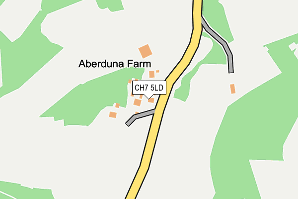
CH7 5LD is in Gwernymynydd, Mold. CH7 5LD is located in the Moel Famau electoral ward, within the unitary authority of Denbighshire and the Welsh Parliamentary constituency of Clwyd West. The Local Health Board is Betsi Cadwaladr University and the police force is North Wales. This postcode has been in use since January 1980.


GetTheData
Source: OS OpenMap – Local (Ordnance Survey)
Source: OS VectorMap District (Ordnance Survey)
Licence: Open Government Licence (requires attribution)
| Easting | 320779 |
| Northing | 362075 |
| Latitude | 53.149914 |
| Longitude | -3.186008 |
GetTheData
Source: Open Postcode Geo
Licence: Open Government Licence
| Locality | Gwernymynydd |
| Town/City | Mold |
| Country | Wales |
| Postcode District | CH7 |
➜ See where CH7 is on a map | |
GetTheData
Source: Land Registry Price Paid Data
Licence: Open Government Licence
Elevation or altitude of CH7 5LD as distance above sea level:
| Metres | Feet | |
|---|---|---|
| Elevation | 240m | 787ft |
Elevation is measured from the approximate centre of the postcode, to the nearest point on an OS contour line from OS Terrain 50, which has contour spacing of ten vertical metres.
➜ How high above sea level am I? Find the elevation of your current position using your device's GPS.
GetTheData
Source: Open Postcode Elevation
Licence: Open Government Licence
| Ward | Moel Famau |
| Constituency | Clwyd West |
GetTheData
Source: ONS Postcode Database
Licence: Open Government Licence
| Maeshafn Turn (A494) | Cadole | 537m |
| Bryntirion Villas (A494) | Cadole | 563m |
| Shop Terrace (A494) | Cadole | 695m |
| Shop Terrace (A494) | Cadole | 697m |
| Cadole Corner (Cadole Road) | Cadole | 710m |
GetTheData
Source: NaPTAN
Licence: Open Government Licence
| Percentage of properties with Next Generation Access | 100.0% |
| Percentage of properties with Superfast Broadband | 0.0% |
| Percentage of properties with Ultrafast Broadband | 0.0% |
| Percentage of properties with Full Fibre Broadband | 0.0% |
Superfast Broadband is between 30Mbps and 300Mbps
Ultrafast Broadband is > 300Mbps
| Percentage of properties unable to receive 2Mbps | 0.0% |
| Percentage of properties unable to receive 5Mbps | 0.0% |
| Percentage of properties unable to receive 10Mbps | 0.0% |
| Percentage of properties unable to receive 30Mbps | 100.0% |
GetTheData
Source: Ofcom
Licence: Ofcom Terms of Use (requires attribution)
GetTheData
Source: ONS Postcode Database
Licence: Open Government Licence


➜ Get more ratings from the Food Standards Agency
GetTheData
Source: Food Standards Agency
Licence: FSA terms & conditions
| Last Collection | |||
|---|---|---|---|
| Location | Mon-Fri | Sat | Distance |
| Gwernymynydd Post Office | 16:50 | 11:30 | 705m |
| Maes Hafn | 16:01 | 09:00 | 1,177m |
| Swan Gwernymynydd | 11:30 | 11:15 | 1,300m |
GetTheData
Source: Dracos
Licence: Creative Commons Attribution-ShareAlike
The below table lists the International Territorial Level (ITL) codes (formerly Nomenclature of Territorial Units for Statistics (NUTS) codes) and Local Administrative Units (LAU) codes for CH7 5LD:
| ITL 1 Code | Name |
|---|---|
| TLL | Wales |
| ITL 2 Code | Name |
| TLL1 | West Wales and The Valleys |
| ITL 3 Code | Name |
| TLL13 | Conwy and Denbighshire |
| LAU 1 Code | Name |
| W06000004 | Denbighshire |
GetTheData
Source: ONS Postcode Directory
Licence: Open Government Licence
The below table lists the Census Output Area (OA), Lower Layer Super Output Area (LSOA), and Middle Layer Super Output Area (MSOA) for CH7 5LD:
| Code | Name | |
|---|---|---|
| OA | W00001085 | |
| LSOA | W01000203 | Denbighshire 013A |
| MSOA | W02000054 | Denbighshire 013 |
GetTheData
Source: ONS Postcode Directory
Licence: Open Government Licence
| CH7 5NG | Bryn Eithin | 461m |
| CH7 5LF | 488m | |
| CH7 5JZ | Bryn Tiron Villas | 523m |
| CH7 5NB | Llys Enfys | 530m |
| CH7 5LQ | Ruthin Road | 563m |
| CH7 5JY | Hafod Drive | 678m |
| CH7 5LG | Ruthin Road | 753m |
| CH7 5LL | 760m | |
| CH7 5FA | 789m | |
| CH7 5LW | Glyndwr Road | 841m |
GetTheData
Source: Open Postcode Geo; Land Registry Price Paid Data
Licence: Open Government Licence