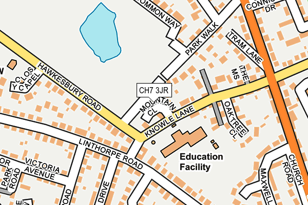
CH7 3JR is located in the Buckley: Pentrobin electoral ward, within the unitary authority of Flintshire and the Welsh Parliamentary constituency of Alyn and Deeside. The Local Health Board is Betsi Cadwaladr University and the police force is North Wales. This postcode has been in use since July 2017.


GetTheData
Source: OS OpenMap – Local (Ordnance Survey)
Source: OS VectorMap District (Ordnance Survey)
Licence: Open Government Licence (requires attribution)
| Easting | 328284 |
| Northing | 364261 |
| Latitude | 53.170625 |
| Longitude | -3.074303 |
GetTheData
Source: Open Postcode Geo
Licence: Open Government Licence
| Country | Wales |
| Postcode District | CH7 |
➜ See where CH7 is on a map ➜ Where is Buckley? | |
GetTheData
Source: Land Registry Price Paid Data
Licence: Open Government Licence
| Ward | Buckley: Pentrobin |
| Constituency | Alyn And Deeside |
GetTheData
Source: ONS Postcode Database
Licence: Open Government Licence
2024 15 JUL £343,000 |
2023 26 OCT £333,000 |
2022 28 JAN £243,000 |
11, MOUNTAIN CLOSE, BUCKLEY, CH7 3JR 2018 7 SEP £245,000 |
15, MOUNTAIN CLOSE, BUCKLEY, CH7 3JR 2018 10 AUG £245,000 |
2018 27 JUL £245,000 |
19, MOUNTAIN CLOSE, BUCKLEY, CH7 3JR 2018 13 JUL £235,000 |
7, MOUNTAIN CLOSE, BUCKLEY, CH7 3JR 2018 11 JUL £245,000 |
20, MOUNTAIN CLOSE, BUCKLEY, CH7 3JR 2018 22 JUN £245,000 |
21, MOUNTAIN CLOSE, BUCKLEY, CH7 3JR 2018 12 JUN £235,000 |
GetTheData
Source: HM Land Registry Price Paid Data
Licence: Contains HM Land Registry data © Crown copyright and database right 2025. This data is licensed under the Open Government Licence v3.0.
| Oak Tree Close (Knowle Lane) | Buckley | 134m |
| Oak Tree Close (Knowle Lane) | Buckley | 151m |
| St John's Church (Hawkesbury Road) | Buckley | 219m |
| St John`s Church (Hawkesbury Road) | Buckley | 221m |
| Horse And Jockey (Drury Lane) | Buckley | 267m |
| Buckley Station | 1.5km |
| Hawarden Station | 3.3km |
| Penyffordd Station | 3.3km |
GetTheData
Source: NaPTAN
Licence: Open Government Licence
| Percentage of properties with Next Generation Access | 100.0% |
| Percentage of properties with Superfast Broadband | 100.0% |
| Percentage of properties with Ultrafast Broadband | 0.0% |
| Percentage of properties with Full Fibre Broadband | 0.0% |
Superfast Broadband is between 30Mbps and 300Mbps
Ultrafast Broadband is > 300Mbps
| Median download speed | 39.1Mbps |
| Average download speed | 46.7Mbps |
| Maximum download speed | 78.12Mbps |
| Median upload speed | 9.8Mbps |
| Average upload speed | 11.0Mbps |
| Maximum upload speed | 19.53Mbps |
| Percentage of properties unable to receive 2Mbps | 0.0% |
| Percentage of properties unable to receive 5Mbps | 0.0% |
| Percentage of properties unable to receive 10Mbps | 0.0% |
| Percentage of properties unable to receive 30Mbps | 0.0% |
GetTheData
Source: Ofcom
Licence: Ofcom Terms of Use (requires attribution)
GetTheData
Source: ONS Postcode Database
Licence: Open Government Licence


➜ Get more ratings from the Food Standards Agency
GetTheData
Source: Food Standards Agency
Licence: FSA terms & conditions
| Last Collection | |||
|---|---|---|---|
| Location | Mon-Fri | Sat | Distance |
| Horse And Jockey | 282m | ||
| Lane End | 16:30 | 11:30 | 596m |
| Liverpool Road Post Office | 16:00 | 11:00 | 638m |
GetTheData
Source: Dracos
Licence: Creative Commons Attribution-ShareAlike
The below table lists the International Territorial Level (ITL) codes (formerly Nomenclature of Territorial Units for Statistics (NUTS) codes) and Local Administrative Units (LAU) codes for CH7 3JR:
| ITL 1 Code | Name |
|---|---|
| TLL | Wales |
| ITL 2 Code | Name |
| TLL2 | East Wales |
| ITL 3 Code | Name |
| TLL23 | Flintshire and Wrexham |
| LAU 1 Code | Name |
| W06000005 | Flintshire |
GetTheData
Source: ONS Postcode Directory
Licence: Open Government Licence
The below table lists the Census Output Area (OA), Lower Layer Super Output Area (LSOA), and Middle Layer Super Output Area (MSOA) for CH7 3JR:
| Code | Name | |
|---|---|---|
| OA | W00001432 | |
| LSOA | W01000268 | Flintshire 013B |
| MSOA | W02000070 | Flintshire 013 |
GetTheData
Source: ONS Postcode Directory
Licence: Open Government Licence
| CH7 3HF | Linthorpe Road | 93m |
| CH7 3JA | Knowle Lane | 120m |
| CH7 3HG | Linthorpe Road | 126m |
| CH7 3HR | Hawkesbury Road | 146m |
| CH7 3JU | Oak Tree Close | 166m |
| CH7 2HF | Victoria Road | 171m |
| CH7 3NA | Park Walk | 174m |
| CH7 3JB | Tram Lane | 195m |
| CH7 3HN | Dukesfield Drive | 209m |
| CH7 3HL | Linthorpe Close | 213m |
GetTheData
Source: Open Postcode Geo; Land Registry Price Paid Data
Licence: Open Government Licence