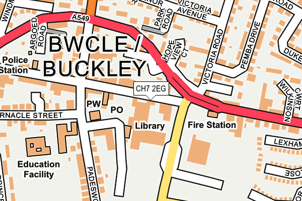
CH7 2EG lies on Precinct Way in Buckley. CH7 2EG is located in the Buckley: Bistre East electoral ward, within the unitary authority of Flintshire and the Welsh Parliamentary constituency of Alyn and Deeside. The Local Health Board is Betsi Cadwaladr University and the police force is North Wales. This postcode has been in use since June 1981.


GetTheData
Source: OS OpenMap – Local (Ordnance Survey)
Source: OS VectorMap District (Ordnance Survey)
Licence: Open Government Licence (requires attribution)
| Easting | 327977 |
| Northing | 363968 |
| Latitude | 53.167951 |
| Longitude | -3.078829 |
GetTheData
Source: Open Postcode Geo
Licence: Open Government Licence
| Street | Precinct Way |
| Town/City | Buckley |
| Country | Wales |
| Postcode District | CH7 |
➜ See where CH7 is on a map ➜ Where is Buckley? | |
GetTheData
Source: Land Registry Price Paid Data
Licence: Open Government Licence
Elevation or altitude of CH7 2EG as distance above sea level:
| Metres | Feet | |
|---|---|---|
| Elevation | 150m | 492ft |
Elevation is measured from the approximate centre of the postcode, to the nearest point on an OS contour line from OS Terrain 50, which has contour spacing of ten vertical metres.
➜ How high above sea level am I? Find the elevation of your current position using your device's GPS.
GetTheData
Source: Open Postcode Elevation
Licence: Open Government Licence
| Ward | Buckley: Bistre East |
| Constituency | Alyn And Deeside |
GetTheData
Source: ONS Postcode Database
Licence: Open Government Licence
| Central Precinct (The Precinct Way) | Buckley | 112m |
| Central Precinct (The Precinct Way) | Buckley | 124m |
| Tivoli (Brunswick Road) | Buckley | 170m |
| Tivoli (Brunswick Road) | Buckley | 171m |
| Police Station (Brunswick Road) | Buckley | 202m |
| Buckley Station | 1.6km |
| Penyffordd Station | 3.2km |
| Hawarden Station | 3.7km |
GetTheData
Source: NaPTAN
Licence: Open Government Licence
GetTheData
Source: ONS Postcode Database
Licence: Open Government Licence


➜ Get more ratings from the Food Standards Agency
GetTheData
Source: Food Standards Agency
Licence: FSA terms & conditions
| Last Collection | |||
|---|---|---|---|
| Location | Mon-Fri | Sat | Distance |
| Nant Mawr Road | 17:01 | 11:30 | 597m |
| Horse And Jockey | 681m | ||
| Lane End | 16:30 | 11:30 | 723m |
GetTheData
Source: Dracos
Licence: Creative Commons Attribution-ShareAlike
The below table lists the International Territorial Level (ITL) codes (formerly Nomenclature of Territorial Units for Statistics (NUTS) codes) and Local Administrative Units (LAU) codes for CH7 2EG:
| ITL 1 Code | Name |
|---|---|
| TLL | Wales |
| ITL 2 Code | Name |
| TLL2 | East Wales |
| ITL 3 Code | Name |
| TLL23 | Flintshire and Wrexham |
| LAU 1 Code | Name |
| W06000005 | Flintshire |
GetTheData
Source: ONS Postcode Directory
Licence: Open Government Licence
The below table lists the Census Output Area (OA), Lower Layer Super Output Area (LSOA), and Middle Layer Super Output Area (MSOA) for CH7 2EG:
| Code | Name | |
|---|---|---|
| OA | W00001404 | |
| LSOA | W01000259 | Flintshire 017A |
| MSOA | W02000074 | Flintshire 017 |
GetTheData
Source: ONS Postcode Directory
Licence: Open Government Licence
| CH7 2EF | Brunswick Road | 2m |
| CH7 2ED | Brunswick Road | 65m |
| CH7 2HB | Parkside | 85m |
| CH7 2EX | Brunswick Road | 95m |
| CH7 2HJ | Hope View Court | 117m |
| CH7 3HD | Millers Court | 119m |
| CH7 2HA | Park Road | 125m |
| CH7 2HD | Victoria Road | 141m |
| CH7 2JP | Padeswood Road | 154m |
| CH7 2HR | Victoria Court | 177m |
GetTheData
Source: Open Postcode Geo; Land Registry Price Paid Data
Licence: Open Government Licence