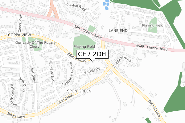
CH7 2DH is located in the Buckley: Bistre East electoral ward, within the unitary authority of Flintshire and the Welsh Parliamentary constituency of Alyn and Deeside. The Local Health Board is Betsi Cadwaladr University and the police force is North Wales. This postcode has been in use since December 2017.


GetTheData
Source: OS Open Zoomstack (Ordnance Survey)
Licence: Open Government Licence (requires attribution)
Attribution: Contains OS data © Crown copyright and database right 2024
Source: Open Postcode Geo
Licence: Open Government Licence (requires attribution)
Attribution: Contains OS data © Crown copyright and database right 2024; Contains Royal Mail data © Royal Mail copyright and database right 2024; Source: Office for National Statistics licensed under the Open Government Licence v.3.0
| Easting | 328853 |
| Northing | 363621 |
| Latitude | 53.164950 |
| Longitude | -3.065650 |
GetTheData
Source: Open Postcode Geo
Licence: Open Government Licence
| Country | Wales |
| Postcode District | CH7 |
➜ See where CH7 is on a map ➜ Where is Buckley? | |
GetTheData
Source: Land Registry Price Paid Data
Licence: Open Government Licence
| Ward | Buckley: Bistre East |
| Constituency | Alyn And Deeside |
GetTheData
Source: ONS Postcode Database
Licence: Open Government Licence
| Spon Green (Bannel Lane) | Buckley | 88m |
| Spon Green (Bannel Lane) | Spon Green | 91m |
| Prince Of Wales Court (Brook Street) | Buckley | 100m |
| Cross Keys Inn (Chester Road) | Buckley | 169m |
| Bank Row (Spon Green) | Buckley | 174m |
| Buckley Station | 0.7km |
| Penyffordd Station | 2.5km |
| Hawarden Station | 3.2km |
GetTheData
Source: NaPTAN
Licence: Open Government Licence
| Percentage of properties with Next Generation Access | 100.0% |
| Percentage of properties with Superfast Broadband | 100.0% |
| Percentage of properties with Ultrafast Broadband | 0.0% |
| Percentage of properties with Full Fibre Broadband | 0.0% |
Superfast Broadband is between 30Mbps and 300Mbps
Ultrafast Broadband is > 300Mbps
| Percentage of properties unable to receive 2Mbps | 0.0% |
| Percentage of properties unable to receive 5Mbps | 0.0% |
| Percentage of properties unable to receive 10Mbps | 0.0% |
| Percentage of properties unable to receive 30Mbps | 0.0% |
GetTheData
Source: Ofcom
Licence: Ofcom Terms of Use (requires attribution)
GetTheData
Source: ONS Postcode Database
Licence: Open Government Licence


➜ Get more ratings from the Food Standards Agency
GetTheData
Source: Food Standards Agency
Licence: FSA terms & conditions
| Last Collection | |||
|---|---|---|---|
| Location | Mon-Fri | Sat | Distance |
| Lane End | 16:30 | 11:30 | 260m |
| Horse And Jockey | 760m | ||
| Warren Crescent | 16:30 | 11:00 | 872m |
GetTheData
Source: Dracos
Licence: Creative Commons Attribution-ShareAlike
The below table lists the International Territorial Level (ITL) codes (formerly Nomenclature of Territorial Units for Statistics (NUTS) codes) and Local Administrative Units (LAU) codes for CH7 2DH:
| ITL 1 Code | Name |
|---|---|
| TLL | Wales |
| ITL 2 Code | Name |
| TLL2 | East Wales |
| ITL 3 Code | Name |
| TLL23 | Flintshire and Wrexham |
| LAU 1 Code | Name |
| W06000005 | Flintshire |
GetTheData
Source: ONS Postcode Directory
Licence: Open Government Licence
The below table lists the Census Output Area (OA), Lower Layer Super Output Area (LSOA), and Middle Layer Super Output Area (MSOA) for CH7 2DH:
| Code | Name | |
|---|---|---|
| OA | W00001403 | |
| LSOA | W01000259 | Flintshire 017A |
| MSOA | W02000074 | Flintshire 017 |
GetTheData
Source: ONS Postcode Directory
Licence: Open Government Licence
| CH7 3BE | Brickfields | 76m |
| CH7 3AS | Prince Of Wales Court | 85m |
| CH7 3AL | Brook Street | 101m |
| CH7 3BH | Spon Green | 108m |
| CH7 3AN | Fern Leigh | 110m |
| CH7 3AW | Rose Mount | 128m |
| CH7 3AQ | Chester Road | 154m |
| CH7 3BA | Westbury Drive | 164m |
| CH7 3BJ | Bank Row | 165m |
| CH7 3BU | Delamere Avenue | 173m |
GetTheData
Source: Open Postcode Geo; Land Registry Price Paid Data
Licence: Open Government Licence