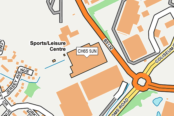
CH65 9JN lies on Stanney Lane in Ellesmere Port. CH65 9JN is located in the Whitby Groves electoral ward, within the unitary authority of Cheshire West and Chester and the English Parliamentary constituency of Ellesmere Port and Neston. The Sub Integrated Care Board (ICB) Location is NHS Cheshire and Merseyside ICB - 27D and the police force is Cheshire. This postcode has been in use since June 1999.


GetTheData
Source: OS OpenMap – Local (Ordnance Survey)
Source: OS VectorMap District (Ordnance Survey)
Licence: Open Government Licence (requires attribution)
| Easting | 340639 |
| Northing | 374450 |
| Latitude | 53.263710 |
| Longitude | -2.891403 |
GetTheData
Source: Open Postcode Geo
Licence: Open Government Licence
| Street | Stanney Lane |
| Town/City | Ellesmere Port |
| Country | England |
| Postcode District | CH65 |
➜ See where CH65 is on a map ➜ Where is Ellesmere Port? | |
GetTheData
Source: Land Registry Price Paid Data
Licence: Open Government Licence
Elevation or altitude of CH65 9JN as distance above sea level:
| Metres | Feet | |
|---|---|---|
| Elevation | 20m | 66ft |
Elevation is measured from the approximate centre of the postcode, to the nearest point on an OS contour line from OS Terrain 50, which has contour spacing of ten vertical metres.
➜ How high above sea level am I? Find the elevation of your current position using your device's GPS.
GetTheData
Source: Open Postcode Elevation
Licence: Open Government Licence
| Ward | Whitby Groves |
| Constituency | Ellesmere Port And Neston |
GetTheData
Source: ONS Postcode Database
Licence: Open Government Licence
| David Lloyd Leisure Centre (Stanney Lane) | Wolverham | 86m |
| David Lloyd Leisure Centre (Stanney Lane) | Wolverham | 91m |
| University Academy South Campus (Stanney Lane) | Wolverham | 118m |
| Longlooms Road | Whitbyheath | 190m |
| Coliseum & Cinema (Coliseum Way) | Cheshire Oaks | 248m |
| Ellesmere Port Station | 2.1km |
| Overpool Station | 3.1km |
| Capenhurst Station | 3.4km |
GetTheData
Source: NaPTAN
Licence: Open Government Licence
GetTheData
Source: ONS Postcode Database
Licence: Open Government Licence


➜ Get more ratings from the Food Standards Agency
GetTheData
Source: Food Standards Agency
Licence: FSA terms & conditions
| Last Collection | |||
|---|---|---|---|
| Location | Mon-Fri | Sat | Distance |
| Coliseum Way | 16:55 | 12:00 | 286m |
| Stanney Oak Estate | 17:07 | 12:00 | 291m |
| Rugby Road | 17:12 | 12:00 | 503m |
GetTheData
Source: Dracos
Licence: Creative Commons Attribution-ShareAlike
The below table lists the International Territorial Level (ITL) codes (formerly Nomenclature of Territorial Units for Statistics (NUTS) codes) and Local Administrative Units (LAU) codes for CH65 9JN:
| ITL 1 Code | Name |
|---|---|
| TLD | North West (England) |
| ITL 2 Code | Name |
| TLD6 | Cheshire |
| ITL 3 Code | Name |
| TLD63 | Cheshire West and Chester |
| LAU 1 Code | Name |
| E06000050 | Cheshire West and Chester |
GetTheData
Source: ONS Postcode Directory
Licence: Open Government Licence
The below table lists the Census Output Area (OA), Lower Layer Super Output Area (LSOA), and Middle Layer Super Output Area (MSOA) for CH65 9JN:
| Code | Name | |
|---|---|---|
| OA | E00093688 | |
| LSOA | E01018566 | Cheshire West and Chester 014B |
| MSOA | E02003851 | Cheshire West and Chester 014 |
GetTheData
Source: ONS Postcode Directory
Licence: Open Government Licence
| CH65 9HZ | Jersey Avenue | 227m |
| CH65 9HY | Wight Close | 254m |
| CH65 9EP | Dover Drive | 254m |
| CH65 9JD | Bardsey Close | 285m |
| CH65 9JE | Arran Avenue | 286m |
| CH65 9HX | Orkney Close | 289m |
| CH65 9HU | Alderney Close | 318m |
| CH65 9JA | Guernsey Drive | 340m |
| CH65 9DN | Stanney Lane | 340m |
| CH65 9HF | Dover Court | 356m |
GetTheData
Source: Open Postcode Geo; Land Registry Price Paid Data
Licence: Open Government Licence