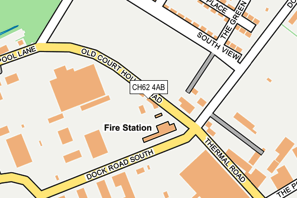
CH62 4AB is located in the Bromborough electoral ward, within the metropolitan district of Wirral and the English Parliamentary constituency of Wirral South. The Sub Integrated Care Board (ICB) Location is NHS Cheshire and Merseyside ICB - 12F and the police force is Merseyside. This postcode has been in use since June 2008.


GetTheData
Source: OS OpenMap – Local (Ordnance Survey)
Source: OS VectorMap District (Ordnance Survey)
Licence: Open Government Licence (requires attribution)
| Easting | 334794 |
| Northing | 383964 |
| Latitude | 53.348528 |
| Longitude | -2.980977 |
GetTheData
Source: Open Postcode Geo
Licence: Open Government Licence
| Country | England |
| Postcode District | CH62 |
➜ See where CH62 is on a map ➜ Where is Bebington? | |
GetTheData
Source: Land Registry Price Paid Data
Licence: Open Government Licence
Elevation or altitude of CH62 4AB as distance above sea level:
| Metres | Feet | |
|---|---|---|
| Elevation | 10m | 33ft |
Elevation is measured from the approximate centre of the postcode, to the nearest point on an OS contour line from OS Terrain 50, which has contour spacing of ten vertical metres.
➜ How high above sea level am I? Find the elevation of your current position using your device's GPS.
GetTheData
Source: Open Postcode Elevation
Licence: Open Government Licence
| Ward | Bromborough |
| Constituency | Wirral South |
GetTheData
Source: ONS Postcode Database
Licence: Open Government Licence
| Thermal Road (Dock Road South) | Bromborough Pool | 109m |
| Bromborough Pool Village (South View) | Bromborough Pool | 161m |
| Bromborough Pool Village (South View) | Bromborough Pool | 171m |
| Dock Road South (Port Causeway) | Bromborough Pool | 289m |
| New Chester Road (Pool Lane) | Bromborough Pool | 303m |
| Port Sunlight Station | 1.1km |
| Spital Station | 1.3km |
| Bebington Station | 1.8km |
GetTheData
Source: NaPTAN
Licence: Open Government Licence
GetTheData
Source: ONS Postcode Database
Licence: Open Government Licence


➜ Get more ratings from the Food Standards Agency
GetTheData
Source: Food Standards Agency
Licence: FSA terms & conditions
| Last Collection | |||
|---|---|---|---|
| Location | Mon-Fri | Sat | Distance |
| Asda Bromborough, | 17:00 | 12:00 | 1,030m |
| Port Sunlight Post Office, | 17:15 | 12:00 | 1,114m |
| The Causeway. | 17:15 | 12:00 | 1,223m |
GetTheData
Source: Dracos
Licence: Creative Commons Attribution-ShareAlike
The below table lists the International Territorial Level (ITL) codes (formerly Nomenclature of Territorial Units for Statistics (NUTS) codes) and Local Administrative Units (LAU) codes for CH62 4AB:
| ITL 1 Code | Name |
|---|---|
| TLD | North West (England) |
| ITL 2 Code | Name |
| TLD7 | Merseyside |
| ITL 3 Code | Name |
| TLD74 | Wirral |
| LAU 1 Code | Name |
| E08000015 | Wirral |
GetTheData
Source: ONS Postcode Directory
Licence: Open Government Licence
The below table lists the Census Output Area (OA), Lower Layer Super Output Area (LSOA), and Middle Layer Super Output Area (MSOA) for CH62 4AB:
| Code | Name | |
|---|---|---|
| OA | E00036150 | |
| LSOA | E01007143 | Wirral 036C |
| MSOA | E02001502 | Wirral 036 |
GetTheData
Source: ONS Postcode Directory
Licence: Open Government Licence
| CH62 4SQ | Dock Road South | 77m |
| CH62 4UB | South View | 92m |
| CH62 4UA | South View | 192m |
| CH62 4TX | Manor Place | 223m |
| CH62 4TY | York Street | 350m |
| CH62 4TA | Port Causeway | 352m |
| CH62 4SZ | Port Causeway | 364m |
| CH62 3ND | Crossways | 415m |
| CH62 3NH | Fairway Crescent | 418m |
| CH62 3LX | Fairway North | 430m |
GetTheData
Source: Open Postcode Geo; Land Registry Price Paid Data
Licence: Open Government Licence