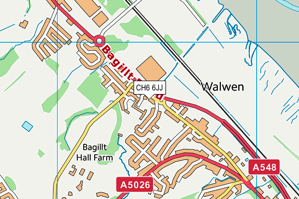
CH6 6JJ is located in the Bagillt electoral ward, within the unitary authority of Flintshire and the Welsh Parliamentary constituency of Delyn. The Local Health Board is Betsi Cadwaladr University and the police force is North Wales. This postcode has been in use since August 1993.


GetTheData
Source: OS OpenMap – Local (Ordnance Survey)
Source: OS VectorMap District (Ordnance Survey)
Licence: Open Government Licence (requires attribution)
| Easting | 320464 |
| Northing | 376711 |
| Latitude | 53.281384 |
| Longitude | -3.194372 |
GetTheData
Source: Open Postcode Geo
Licence: Open Government Licence
| Country | Wales |
| Postcode District | CH6 |
➜ See where CH6 is on a map ➜ Where is Walwen? | |
GetTheData
Source: Land Registry Price Paid Data
Licence: Open Government Licence
Elevation or altitude of CH6 6JJ as distance above sea level:
| Metres | Feet | |
|---|---|---|
| Elevation | 10m | 33ft |
Elevation is measured from the approximate centre of the postcode, to the nearest point on an OS contour line from OS Terrain 50, which has contour spacing of ten vertical metres.
➜ How high above sea level am I? Find the elevation of your current position using your device's GPS.
GetTheData
Source: Open Postcode Elevation
Licence: Open Government Licence
| Ward | Bagillt |
| Constituency | Delyn |
GetTheData
Source: ONS Postcode Database
Licence: Open Government Licence
| Riverbank House (Bagillt Road) | Wal-wen | 26m |
| Victoria Inn (Strand Villas) | Wal-wen | 133m |
| Glan-y-don (Bagillt Road) | Wal-wen | 192m |
| Glan-y-don (Bagillt Road) | Wal-wen | 198m |
| Victoria Inn (Brighton Terrace) | Wal-wen | 306m |
| Flint Station | 5.4km |
GetTheData
Source: NaPTAN
Licence: Open Government Licence
GetTheData
Source: ONS Postcode Database
Licence: Open Government Licence


➜ Get more ratings from the Food Standards Agency
GetTheData
Source: Food Standards Agency
Licence: FSA terms & conditions
| Last Collection | |||
|---|---|---|---|
| Location | Mon-Fri | Sat | Distance |
| Greenfield Post Office | 17:00 | 11:30 | 1,338m |
| Bagillt Post Office | 17:00 | 12:15 | 1,941m |
| Pantasaph | 09:00 | 08:30 | 2,000m |
GetTheData
Source: Dracos
Licence: Creative Commons Attribution-ShareAlike
The below table lists the International Territorial Level (ITL) codes (formerly Nomenclature of Territorial Units for Statistics (NUTS) codes) and Local Administrative Units (LAU) codes for CH6 6JJ:
| ITL 1 Code | Name |
|---|---|
| TLL | Wales |
| ITL 2 Code | Name |
| TLL2 | East Wales |
| ITL 3 Code | Name |
| TLL23 | Flintshire and Wrexham |
| LAU 1 Code | Name |
| W06000005 | Flintshire |
GetTheData
Source: ONS Postcode Directory
Licence: Open Government Licence
The below table lists the Census Output Area (OA), Lower Layer Super Output Area (LSOA), and Middle Layer Super Output Area (MSOA) for CH6 6JJ:
| Code | Name | |
|---|---|---|
| OA | W00001362 | |
| LSOA | W01000254 | Flintshire 003B |
| MSOA | W02000060 | Flintshire 003 |
GetTheData
Source: ONS Postcode Directory
Licence: Open Government Licence
| CH8 7PB | Bagillt Road | 68m |
| CH6 6LA | Ffordd Canton | 71m |
| CH8 7FA | Llys Maes Teg | 95m |
| CH6 6JL | Upper Riverbank | 116m |
| CH8 7HG | Glan Y Don | 214m |
| CH8 7HQ | Glan Y Don | 226m |
| CH6 6JW | Riverbank | 235m |
| CH6 6JN | Victoria Road | 263m |
| CH6 6JB | Bagillt Road | 280m |
| CH6 6JQ | Walwen Isaf | 293m |
GetTheData
Source: Open Postcode Geo; Land Registry Price Paid Data
Licence: Open Government Licence