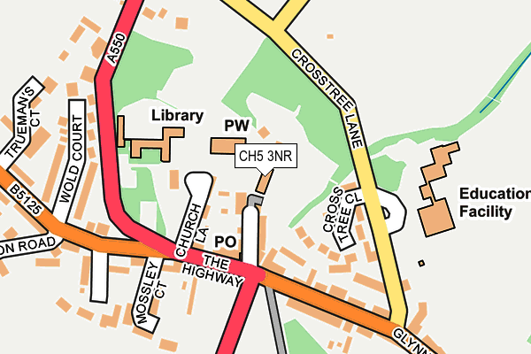
CH5 3NR is located in the Hawarden: Mancot electoral ward, within the unitary authority of Flintshire and the Welsh Parliamentary constituency of Alyn and Deeside. The Local Health Board is Betsi Cadwaladr University and the police force is North Wales. This postcode has been in use since January 1980.


GetTheData
Source: OS OpenMap – Local (Ordnance Survey)
Source: OS VectorMap District (Ordnance Survey)
Licence: Open Government Licence (requires attribution)
| Easting | 331589 |
| Northing | 365882 |
| Latitude | 53.185614 |
| Longitude | -3.025218 |
GetTheData
Source: Open Postcode Geo
Licence: Open Government Licence
| Country | Wales |
| Postcode District | CH5 |
➜ See where CH5 is on a map ➜ Where is Hawarden? | |
GetTheData
Source: Land Registry Price Paid Data
Licence: Open Government Licence
Elevation or altitude of CH5 3NR as distance above sea level:
| Metres | Feet | |
|---|---|---|
| Elevation | 70m | 230ft |
Elevation is measured from the approximate centre of the postcode, to the nearest point on an OS contour line from OS Terrain 50, which has contour spacing of ten vertical metres.
➜ How high above sea level am I? Find the elevation of your current position using your device's GPS.
GetTheData
Source: Open Postcode Elevation
Licence: Open Government Licence
| Ward | Hawarden: Mancot |
| Constituency | Alyn And Deeside |
GetTheData
Source: ONS Postcode Database
Licence: Open Government Licence
| Glynne Arms (Glynne Way) | Hawarden | 112m |
| Glynne Arms (Glynne Way) | Hawarden | 121m |
| Glynne Arms (A550) | Hawarden | 144m |
| Memorial (Gladstone Way) | Hawarden | 158m |
| Mossley Court (The Highway) | Hawarden | 169m |
| Hawarden Station | 0.5km |
| Shotton Station | 3.1km |
| Buckley Station | 3.2km |
GetTheData
Source: NaPTAN
Licence: Open Government Licence
GetTheData
Source: ONS Postcode Database
Licence: Open Government Licence


➜ Get more ratings from the Food Standards Agency
GetTheData
Source: Food Standards Agency
Licence: FSA terms & conditions
| Last Collection | |||
|---|---|---|---|
| Location | Mon-Fri | Sat | Distance |
| Hawarden Post Office, | 16:00 | 11:30 | 95m |
| Hawarden Station, | 17:30 | 07:00 | 435m |
| Fieldside | 16:00 | 07:00 | 726m |
GetTheData
Source: Dracos
Licence: Creative Commons Attribution-ShareAlike
The below table lists the International Territorial Level (ITL) codes (formerly Nomenclature of Territorial Units for Statistics (NUTS) codes) and Local Administrative Units (LAU) codes for CH5 3NR:
| ITL 1 Code | Name |
|---|---|
| TLL | Wales |
| ITL 2 Code | Name |
| TLL2 | East Wales |
| ITL 3 Code | Name |
| TLL23 | Flintshire and Wrexham |
| LAU 1 Code | Name |
| W06000005 | Flintshire |
GetTheData
Source: ONS Postcode Directory
Licence: Open Government Licence
The below table lists the Census Output Area (OA), Lower Layer Super Output Area (LSOA), and Middle Layer Super Output Area (MSOA) for CH5 3NR:
| Code | Name | |
|---|---|---|
| OA | W00001621 | |
| LSOA | W01000302 | Flintshire 013F |
| MSOA | W02000070 | Flintshire 013 |
GetTheData
Source: ONS Postcode Directory
Licence: Open Government Licence
| CH5 3NN | Rectory Drive | 53m |
| CH5 3LT | Church Lane | 83m |
| CH5 3PX | Cross Tree Close | 84m |
| CH5 3PY | Cross Tree Lane | 152m |
| CH5 3GX | Gladstone Court | 166m |
| CH5 3DQ | Mossley Court | 199m |
| CH5 3NS | Glynne Way | 203m |
| CH5 3NL | Glynne Way | 206m |
| CH5 3LN | Wold Court | 237m |
| CH5 3DW | Springfield | 239m |
GetTheData
Source: Open Postcode Geo; Land Registry Price Paid Data
Licence: Open Government Licence