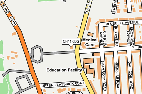
CH41 0DG is located in the Bidston and St James electoral ward, within the metropolitan district of Wirral and the English Parliamentary constituency of Birkenhead. The Sub Integrated Care Board (ICB) Location is NHS Cheshire and Merseyside ICB - 12F and the police force is Merseyside. This postcode has been in use since June 1999.


GetTheData
Source: OS OpenMap – Local (Ordnance Survey)
Source: OS VectorMap District (Ordnance Survey)
Licence: Open Government Licence (requires attribution)
| Easting | 329395 |
| Northing | 389437 |
| Latitude | 53.397020 |
| Longitude | -3.063290 |
GetTheData
Source: Open Postcode Geo
Licence: Open Government Licence
| Country | England |
| Postcode District | CH41 |
➜ See where CH41 is on a map ➜ Where is Birkenhead? | |
GetTheData
Source: Land Registry Price Paid Data
Licence: Open Government Licence
Elevation or altitude of CH41 0DG as distance above sea level:
| Metres | Feet | |
|---|---|---|
| Elevation | 30m | 98ft |
Elevation is measured from the approximate centre of the postcode, to the nearest point on an OS contour line from OS Terrain 50, which has contour spacing of ten vertical metres.
➜ How high above sea level am I? Find the elevation of your current position using your device's GPS.
GetTheData
Source: Open Postcode Elevation
Licence: Open Government Licence
| Ward | Bidston And St James |
| Constituency | Birkenhead |
GetTheData
Source: ONS Postcode Database
Licence: Open Government Licence
| Bidston Avenue (Tollemache Road) | Claughton | 43m |
| Bidston Avenue (Tollemache Road) | Claughton | 69m |
| Flaybrick Close (Tollemache Road) | Claughton | 169m |
| Wilfred Owen Drive (Upton Road) | Upton | 301m |
| Flaybrick Close (Tollemache Road) | Birkenhead | 309m |
| Birkenhead North Station | 0.9km |
| Birkenhead Park Station | 1.6km |
| Bidston Station | 1.7km |
GetTheData
Source: NaPTAN
Licence: Open Government Licence
Estimated total energy consumption in CH41 0DG by fuel type, 2015.
| Consumption (kWh) | 35,046 |
|---|---|
| Meter count | 13 |
| Mean (kWh/meter) | 2,696 |
| Median (kWh/meter) | 2,498 |
GetTheData
Source: Postcode level gas estimates: 2015 (experimental)
Source: Postcode level electricity estimates: 2015 (experimental)
Licence: Open Government Licence
GetTheData
Source: ONS Postcode Database
Licence: Open Government Licence


➜ Get more ratings from the Food Standards Agency
GetTheData
Source: Food Standards Agency
Licence: FSA terms & conditions
| Last Collection | |||
|---|---|---|---|
| Location | Mon-Fri | Sat | Distance |
| Buccleugh Street | 17:15 | 12:00 | 727m |
| Ashville Road | 17:15 | 12:00 | 1,393m |
| Alton Road | 17:30 | 12:00 | 1,739m |
GetTheData
Source: Dracos
Licence: Creative Commons Attribution-ShareAlike
The below table lists the International Territorial Level (ITL) codes (formerly Nomenclature of Territorial Units for Statistics (NUTS) codes) and Local Administrative Units (LAU) codes for CH41 0DG:
| ITL 1 Code | Name |
|---|---|
| TLD | North West (England) |
| ITL 2 Code | Name |
| TLD7 | Merseyside |
| ITL 3 Code | Name |
| TLD74 | Wirral |
| LAU 1 Code | Name |
| E08000015 | Wirral |
GetTheData
Source: ONS Postcode Directory
Licence: Open Government Licence
The below table lists the Census Output Area (OA), Lower Layer Super Output Area (LSOA), and Middle Layer Super Output Area (MSOA) for CH41 0DG:
| Code | Name | |
|---|---|---|
| OA | E00036281 | |
| LSOA | E01007157 | Wirral 015C |
| MSOA | E02001481 | Wirral 015 |
GetTheData
Source: ONS Postcode Directory
Licence: Open Government Licence
| CH41 0DL | Tollemache Road | 102m |
| CH41 0DR | Crocus Avenue | 146m |
| CH41 0DU | Bidston Avenue | 155m |
| CH41 0EW | Bidston Avenue | 167m |
| CH41 0EG | Shamrock Road | 170m |
| CH41 0EQ | Shamrock Road | 193m |
| CH41 0DQ | Tollemache Road | 204m |
| CH41 0DX | Iris Avenue | 211m |
| CH41 0EE | Primrose Road | 216m |
| CH41 0HA | Wilfred Owen Drive | 234m |
GetTheData
Source: Open Postcode Geo; Land Registry Price Paid Data
Licence: Open Government Licence