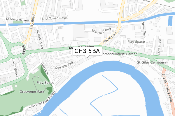
CH3 5BA is located in the Chester City & the Garden Quarter electoral ward, within the unitary authority of Cheshire West and Chester and the English Parliamentary constituency of City of Chester. The Sub Integrated Care Board (ICB) Location is NHS Cheshire and Merseyside ICB - 27D and the police force is Cheshire. This postcode has been in use since April 2018.


GetTheData
Source: OS Open Zoomstack (Ordnance Survey)
Licence: Open Government Licence (requires attribution)
Attribution: Contains OS data © Crown copyright and database right 2025
Source: Open Postcode Geo
Licence: Open Government Licence (requires attribution)
Attribution: Contains OS data © Crown copyright and database right 2025; Contains Royal Mail data © Royal Mail copyright and database right 2025; Source: Office for National Statistics licensed under the Open Government Licence v.3.0
| Easting | 341519 |
| Northing | 366447 |
| Latitude | 53.191894 |
| Longitude | -2.876743 |
GetTheData
Source: Open Postcode Geo
Licence: Open Government Licence
| Country | England |
| Postcode District | CH3 |
➜ See where CH3 is on a map ➜ Where is Chester? | |
GetTheData
Source: Land Registry Price Paid Data
Licence: Open Government Licence
| Ward | Chester City & The Garden Quarter |
| Constituency | City Of Chester |
GetTheData
Source: ONS Postcode Database
Licence: Open Government Licence
| Health Centre (Boughton) | Boughton | 63m |
| Health Centre (Boughton) | Boughton | 80m |
| Steam Mill Street (The Bars) | Boughton | 239m |
| St Paul's Church (Boughton) | Boughton | 298m |
| Lock Vaults Ph (Hoole Lane) | Hoole | 307m |
| Chester Station | 0.6km |
| Bache Station | 2.1km |
GetTheData
Source: NaPTAN
Licence: Open Government Licence
| Percentage of properties with Next Generation Access | 100.0% |
| Percentage of properties with Superfast Broadband | 100.0% |
| Percentage of properties with Ultrafast Broadband | 100.0% |
| Percentage of properties with Full Fibre Broadband | 0.0% |
Superfast Broadband is between 30Mbps and 300Mbps
Ultrafast Broadband is > 300Mbps
| Percentage of properties unable to receive 2Mbps | 0.0% |
| Percentage of properties unable to receive 5Mbps | 0.0% |
| Percentage of properties unable to receive 10Mbps | 0.0% |
| Percentage of properties unable to receive 30Mbps | 0.0% |
GetTheData
Source: Ofcom
Licence: Ofcom Terms of Use (requires attribution)
GetTheData
Source: ONS Postcode Database
Licence: Open Government Licence


➜ Get more ratings from the Food Standards Agency
GetTheData
Source: Food Standards Agency
Licence: FSA terms & conditions
| Last Collection | |||
|---|---|---|---|
| Location | Mon-Fri | Sat | Distance |
| Brook Street | 17:45 | 12:45 | 191m |
| City Road. | 18:30 | 12:30 | 363m |
| The Groves. | 17:45 | 12:45 | 638m |
GetTheData
Source: Dracos
Licence: Creative Commons Attribution-ShareAlike
The below table lists the International Territorial Level (ITL) codes (formerly Nomenclature of Territorial Units for Statistics (NUTS) codes) and Local Administrative Units (LAU) codes for CH3 5BA:
| ITL 1 Code | Name |
|---|---|
| TLD | North West (England) |
| ITL 2 Code | Name |
| TLD6 | Cheshire |
| ITL 3 Code | Name |
| TLD63 | Cheshire West and Chester |
| LAU 1 Code | Name |
| E06000050 | Cheshire West and Chester |
GetTheData
Source: ONS Postcode Directory
Licence: Open Government Licence
The below table lists the Census Output Area (OA), Lower Layer Super Output Area (LSOA), and Middle Layer Super Output Area (MSOA) for CH3 5BA:
| Code | Name | |
|---|---|---|
| OA | E00168836 | |
| LSOA | E01032931 | Cheshire West and Chester 033F |
| MSOA | E02003802 | Cheshire West and Chester 033 |
GetTheData
Source: ONS Postcode Directory
Licence: Open Government Licence
| CH3 5AU | Dee Hills Park | 46m |
| CH3 5AQ | Boughton | 60m |
| CH3 5BN | Sandown Terrace | 63m |
| CH3 5BP | Boughton | 96m |
| CH3 5AZ | Beaconsfield Street | 130m |
| CH3 5AR | Dee Hills Park | 140m |
| CH3 5AY | Beaconsfield Street | 141m |
| CH3 5AF | Boughton | 164m |
| CH2 3DG | Wharton Court | 176m |
| CH3 5BQ | Earlston Court | 177m |
GetTheData
Source: Open Postcode Geo; Land Registry Price Paid Data
Licence: Open Government Licence