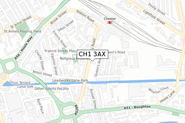
CH1 3AX is located in the Chester City & the Garden Quarter electoral ward, within the unitary authority of Cheshire West and Chester and the English Parliamentary constituency of City of Chester. The Sub Integrated Care Board (ICB) Location is NHS Cheshire and Merseyside ICB - 27D and the police force is Cheshire. This postcode has been in use since April 2019.


GetTheData
Source: OS Open Zoomstack (Ordnance Survey)
Licence: Open Government Licence (requires attribution)
Attribution: Contains OS data © Crown copyright and database right 2025
Source: Open Postcode Geo
Licence: Open Government Licence (requires attribution)
Attribution: Contains OS data © Crown copyright and database right 2025; Contains Royal Mail data © Royal Mail copyright and database right 2025; Source: Office for National Statistics licensed under the Open Government Licence v.3.0
| Easting | 341242 |
| Northing | 366757 |
| Latitude | 53.194649 |
| Longitude | -2.880945 |
GetTheData
Source: Open Postcode Geo
Licence: Open Government Licence
| Country | England |
| Postcode District | CH1 |
➜ See where CH1 is on a map ➜ Where is Chester? | |
GetTheData
Source: Land Registry Price Paid Data
Licence: Open Government Licence
| Ward | Chester City & The Garden Quarter |
| Constituency | City Of Chester |
GetTheData
Source: ONS Postcode Database
Licence: Open Government Licence
| Railway Station (City Road) | Chester | 158m |
| Crewe Street (Francis Street) | Chester | 158m |
| Railway Station Coach Stop (City Road) | Chester | 161m |
| Crewe Street (Francis Street) | Chester | 166m |
| Railway Station (City Road) | Chester | 174m |
| Chester Station | 0.2km |
| Bache Station | 1.7km |
GetTheData
Source: NaPTAN
Licence: Open Government Licence
| Percentage of properties with Next Generation Access | 100.0% |
| Percentage of properties with Superfast Broadband | 100.0% |
| Percentage of properties with Ultrafast Broadband | 100.0% |
| Percentage of properties with Full Fibre Broadband | 0.0% |
Superfast Broadband is between 30Mbps and 300Mbps
Ultrafast Broadband is > 300Mbps
| Percentage of properties unable to receive 2Mbps | 0.0% |
| Percentage of properties unable to receive 5Mbps | 0.0% |
| Percentage of properties unable to receive 10Mbps | 0.0% |
| Percentage of properties unable to receive 30Mbps | 0.0% |
GetTheData
Source: Ofcom
Licence: Ofcom Terms of Use (requires attribution)
GetTheData
Source: ONS Postcode Database
Licence: Open Government Licence


➜ Get more ratings from the Food Standards Agency
GetTheData
Source: Food Standards Agency
Licence: FSA terms & conditions
| Last Collection | |||
|---|---|---|---|
| Location | Mon-Fri | Sat | Distance |
| City Road. | 18:30 | 12:30 | 194m |
| Brook Street | 17:45 | 12:45 | 256m |
| Station View, | 16:00 | 13:15 | 296m |
GetTheData
Source: Dracos
Licence: Creative Commons Attribution-ShareAlike
The below table lists the International Territorial Level (ITL) codes (formerly Nomenclature of Territorial Units for Statistics (NUTS) codes) and Local Administrative Units (LAU) codes for CH1 3AX:
| ITL 1 Code | Name |
|---|---|
| TLD | North West (England) |
| ITL 2 Code | Name |
| TLD6 | Cheshire |
| ITL 3 Code | Name |
| TLD63 | Cheshire West and Chester |
| LAU 1 Code | Name |
| E06000050 | Cheshire West and Chester |
GetTheData
Source: ONS Postcode Directory
Licence: Open Government Licence
The below table lists the Census Output Area (OA), Lower Layer Super Output Area (LSOA), and Middle Layer Super Output Area (MSOA) for CH1 3AX:
| Code | Name | |
|---|---|---|
| OA | E00168834 | |
| LSOA | E01032931 | Cheshire West and Chester 033F |
| MSOA | E02003802 | Cheshire West and Chester 033 |
GetTheData
Source: ONS Postcode Directory
Licence: Open Government Licence
| CH1 3AD | Car Street | 32m |
| CH1 3BG | Queens Avenue | 49m |
| CH1 3BR | Nelson Street | 63m |
| CH1 3BP | Crewe Street | 84m |
| CH1 3AB | City Road | 102m |
| CH1 3BH | Princes Avenue | 111m |
| CH1 3BT | Shot Tower Close | 125m |
| CH1 3BN | Francis Street | 127m |
| CH1 3BQ | Queens Road | 131m |
| CH1 3BD | Francis Street | 132m |
GetTheData
Source: Open Postcode Geo; Land Registry Price Paid Data
Licence: Open Government Licence