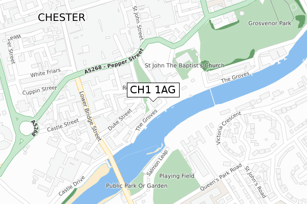
CH1 1AG is located in the Chester City & the Garden Quarter electoral ward, within the unitary authority of Cheshire West and Chester and the English Parliamentary constituency of City of Chester. The Sub Integrated Care Board (ICB) Location is NHS Cheshire and Merseyside ICB - 27D and the police force is Cheshire. This postcode has been in use since November 2017.


GetTheData
Source: OS Open Zoomstack (Ordnance Survey)
Licence: Open Government Licence (requires attribution)
Attribution: Contains OS data © Crown copyright and database right 2025
Source: Open Postcode Geo
Licence: Open Government Licence (requires attribution)
Attribution: Contains OS data © Crown copyright and database right 2025; Contains Royal Mail data © Royal Mail copyright and database right 2025; Source: Office for National Statistics licensed under the Open Government Licence v.3.0
| Easting | 340821 |
| Northing | 365995 |
| Latitude | 53.187754 |
| Longitude | -2.887104 |
GetTheData
Source: Open Postcode Geo
Licence: Open Government Licence
| Country | England |
| Postcode District | CH1 |
➜ See where CH1 is on a map ➜ Where is Chester? | |
GetTheData
Source: Land Registry Price Paid Data
Licence: Open Government Licence
| Ward | Chester City & The Garden Quarter |
| Constituency | City Of Chester |
GetTheData
Source: ONS Postcode Database
Licence: Open Government Licence
| The Grooves Tour Stop (The Grooves) | Chester | 45m |
| Visitor's Centre (Vicar's Lane) | Chester | 208m |
| Park & Ride (Pepper Street) | Chester | 213m |
| Pepper Street | Chester | 216m |
| Ye Olde Kings Head (Lower Bridge Street) | Chester | 227m |
| Chester Station | 1.1km |
| Bache Station | 2.4km |
GetTheData
Source: NaPTAN
Licence: Open Government Licence
GetTheData
Source: ONS Postcode Database
Licence: Open Government Licence


➜ Get more ratings from the Food Standards Agency
GetTheData
Source: Food Standards Agency
Licence: FSA terms & conditions
| Last Collection | |||
|---|---|---|---|
| Location | Mon-Fri | Sat | Distance |
| Pepper Street. | 18:30 | 13:00 | 162m |
| The Groves. | 17:45 | 12:45 | 194m |
| St. John Street Post Office. | 18:30 | 12:45 | 296m |
GetTheData
Source: Dracos
Licence: Creative Commons Attribution-ShareAlike
| Risk of CH1 1AG flooding from rivers and sea | Medium |
| ➜ CH1 1AG flood map | |
GetTheData
Source: Open Flood Risk by Postcode
Licence: Open Government Licence
The below table lists the International Territorial Level (ITL) codes (formerly Nomenclature of Territorial Units for Statistics (NUTS) codes) and Local Administrative Units (LAU) codes for CH1 1AG:
| ITL 1 Code | Name |
|---|---|
| TLD | North West (England) |
| ITL 2 Code | Name |
| TLD6 | Cheshire |
| ITL 3 Code | Name |
| TLD63 | Cheshire West and Chester |
| LAU 1 Code | Name |
| E06000050 | Cheshire West and Chester |
GetTheData
Source: ONS Postcode Directory
Licence: Open Government Licence
The below table lists the Census Output Area (OA), Lower Layer Super Output Area (LSOA), and Middle Layer Super Output Area (MSOA) for CH1 1AG:
| Code | Name | |
|---|---|---|
| OA | E00092441 | |
| LSOA | E01018326 | Cheshire West and Chester 034A |
| MSOA | E02003803 | Cheshire West and Chester 034 |
GetTheData
Source: ONS Postcode Directory
Licence: Open Government Licence
| CH1 1NE | Duke Street | 68m |
| CH1 1RW | Albion Place | 77m |
| CH1 1RP | Duke Street | 97m |
| CH1 1RQ | Albion Street | 99m |
| CH1 1RH | Steele Street | 122m |
| CH1 1SB | City Walls | 125m |
| CH1 1RG | Volunteer Street | 142m |
| CH1 1QS | Duke Street | 157m |
| CH1 1RJ | St Olave Street | 178m |
| CH1 1DF | Pepper Street | 183m |
GetTheData
Source: Open Postcode Geo; Land Registry Price Paid Data
Licence: Open Government Licence