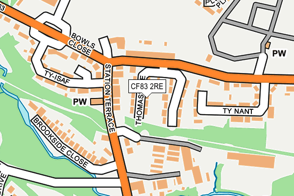
CF83 2RE lies on Thomasville in Caerphilly. CF83 2RE is located in the Penyrheol electoral ward, within the unitary authority of Caerphilly and the Welsh Parliamentary constituency of Caerphilly. The Local Health Board is Aneurin Bevan University and the police force is Gwent. This postcode has been in use since July 1995.


GetTheData
Source: OS OpenMap – Local (Ordnance Survey)
Source: OS VectorMap District (Ordnance Survey)
Licence: Open Government Licence (requires attribution)
| Easting | 314118 |
| Northing | 187989 |
| Latitude | 51.584191 |
| Longitude | -3.240942 |
GetTheData
Source: Open Postcode Geo
Licence: Open Government Licence
| Street | Thomasville |
| Town/City | Caerphilly |
| Country | Wales |
| Postcode District | CF83 |
➜ See where CF83 is on a map ➜ Where is Caerphilly? | |
GetTheData
Source: Land Registry Price Paid Data
Licence: Open Government Licence
Elevation or altitude of CF83 2RE as distance above sea level:
| Metres | Feet | |
|---|---|---|
| Elevation | 110m | 361ft |
Elevation is measured from the approximate centre of the postcode, to the nearest point on an OS contour line from OS Terrain 50, which has contour spacing of ten vertical metres.
➜ How high above sea level am I? Find the elevation of your current position using your device's GPS.
GetTheData
Source: Open Postcode Elevation
Licence: Open Government Licence
| Ward | Penyrheol |
| Constituency | Caerphilly |
GetTheData
Source: ONS Postcode Database
Licence: Open Government Licence
| Scout Hall (B4263) | Penyrheol | 103m |
| The Dip (St Cenydd Road) | Hendredenny | 130m |
| Scout Hall (B4263) | Penyrheol | 131m |
| The Dip (St Cenydd Road) | Hendredenny | 135m |
| Bowls Inn (B4263) | Penyrheol | 208m |
| Energlyn & Churchill Park Station | 0.8km |
| Aber Station | 1.3km |
| Caerphilly Station | 2.1km |
GetTheData
Source: NaPTAN
Licence: Open Government Licence
| Percentage of properties with Next Generation Access | 100.0% |
| Percentage of properties with Superfast Broadband | 96.9% |
| Percentage of properties with Ultrafast Broadband | 0.0% |
| Percentage of properties with Full Fibre Broadband | 0.0% |
Superfast Broadband is between 30Mbps and 300Mbps
Ultrafast Broadband is > 300Mbps
| Median download speed | 32.9Mbps |
| Average download speed | 25.3Mbps |
| Maximum download speed | 60.00Mbps |
| Median upload speed | 3.0Mbps |
| Average upload speed | 3.9Mbps |
| Maximum upload speed | 13.24Mbps |
| Percentage of properties unable to receive 2Mbps | 0.0% |
| Percentage of properties unable to receive 5Mbps | 0.0% |
| Percentage of properties unable to receive 10Mbps | 0.0% |
| Percentage of properties unable to receive 30Mbps | 3.1% |
GetTheData
Source: Ofcom
Licence: Ofcom Terms of Use (requires attribution)
Estimated total energy consumption in CF83 2RE by fuel type, 2015.
| Consumption (kWh) | 358,849 |
|---|---|
| Meter count | 32 |
| Mean (kWh/meter) | 11,214 |
| Median (kWh/meter) | 12,449 |
| Consumption (kWh) | 111,124 |
|---|---|
| Meter count | 29 |
| Mean (kWh/meter) | 3,832 |
| Median (kWh/meter) | 2,879 |
GetTheData
Source: Postcode level gas estimates: 2015 (experimental)
Source: Postcode level electricity estimates: 2015 (experimental)
Licence: Open Government Licence
GetTheData
Source: ONS Postcode Database
Licence: Open Government Licence


➜ Get more ratings from the Food Standards Agency
GetTheData
Source: Food Standards Agency
Licence: FSA terms & conditions
| Last Collection | |||
|---|---|---|---|
| Location | Mon-Fri | Sat | Distance |
| Mill Road | 16:30 | 12:00 | 1,262m |
| Nantgarw Road | 17:15 | 12:00 | 1,283m |
| Blockbusters | 16:15 | 12:15 | 1,664m |
GetTheData
Source: Dracos
Licence: Creative Commons Attribution-ShareAlike
The below table lists the International Territorial Level (ITL) codes (formerly Nomenclature of Territorial Units for Statistics (NUTS) codes) and Local Administrative Units (LAU) codes for CF83 2RE:
| ITL 1 Code | Name |
|---|---|
| TLL | Wales |
| ITL 2 Code | Name |
| TLL1 | West Wales and The Valleys |
| ITL 3 Code | Name |
| TLL16 | Gwent Valleys |
| LAU 1 Code | Name |
| W06000018 | Caerphilly |
GetTheData
Source: ONS Postcode Directory
Licence: Open Government Licence
The below table lists the Census Output Area (OA), Lower Layer Super Output Area (LSOA), and Middle Layer Super Output Area (MSOA) for CF83 2RE:
| Code | Name | |
|---|---|---|
| OA | W00007305 | |
| LSOA | W01001395 | Caerphilly 023C |
| MSOA | W02000312 | Caerphilly 023 |
GetTheData
Source: ONS Postcode Directory
Licence: Open Government Licence
| CF83 2RH | Station Terrace | 61m |
| CF83 2RD | Bowls Terrace | 91m |
| CF83 2RQ | Bowls Close | 126m |
| CF83 2RA | Ty Nant | 153m |
| CF83 2RR | Brookside Close | 187m |
| CF83 2RG | Ty Isaf | 201m |
| CF83 2RP | St Cenydd Road | 282m |
| CF83 2PW | Troed Y Bryn | 292m |
| CF83 2PX | Troed Y Bryn | 320m |
| CF83 2TJ | Caldicot Court | 335m |
GetTheData
Source: Open Postcode Geo; Land Registry Price Paid Data
Licence: Open Government Licence