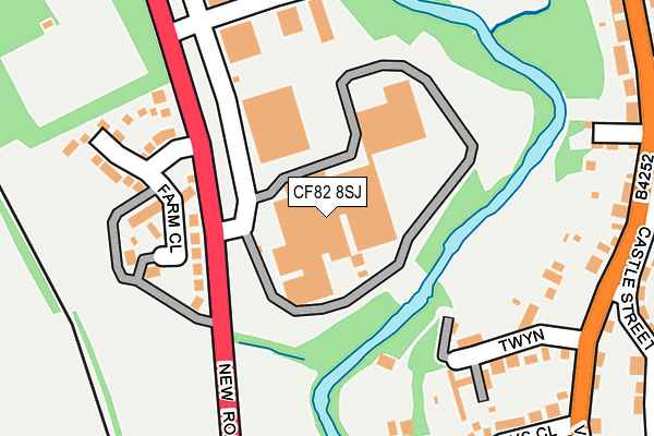
CF82 8SJ is located in the Hengoed electoral ward, within the unitary authority of Caerphilly and the Welsh Parliamentary constituency of Caerphilly. The Local Health Board is Aneurin Bevan University and the police force is Gwent. This postcode has been in use since August 2005.


GetTheData
Source: OS OpenMap – Local (Ordnance Survey)
Source: OS VectorMap District (Ordnance Survey)
Licence: Open Government Licence (requires attribution)
| Easting | 315305 |
| Northing | 196278 |
| Latitude | 51.658881 |
| Longitude | -3.225811 |
GetTheData
Source: Open Postcode Geo
Licence: Open Government Licence
| Country | Wales |
| Postcode District | CF82 |
➜ See where CF82 is on a map ➜ Where is Tir-y-berth? | |
GetTheData
Source: Land Registry Price Paid Data
Licence: Open Government Licence
Elevation or altitude of CF82 8SJ as distance above sea level:
| Metres | Feet | |
|---|---|---|
| Elevation | 130m | 427ft |
Elevation is measured from the approximate centre of the postcode, to the nearest point on an OS contour line from OS Terrain 50, which has contour spacing of ten vertical metres.
➜ How high above sea level am I? Find the elevation of your current position using your device's GPS.
GetTheData
Source: Open Postcode Elevation
Licence: Open Government Licence
| Ward | Hengoed |
| Constituency | Caerphilly |
GetTheData
Source: ONS Postcode Database
Licence: Open Government Licence
| Tiryberth Industrial Est (New Road) | Tir-y-berth | 192m |
| Tiryberth Industrial Est (New Road) | Tir-y-berth | 215m |
| Tiryberth Street (Cardiff Road) | Tir-y-berth | 444m |
| Gwent Court (High Street) | Fleur-de-lis | 467m |
| Allotments (Cardiff Road) | Tir-y-berth | 477m |
| Hengoed Station | 1.3km |
| Pengam Station | 1.3km |
| Ystrad Mynach Station | 2.3km |
GetTheData
Source: NaPTAN
Licence: Open Government Licence
GetTheData
Source: ONS Postcode Database
Licence: Open Government Licence


➜ Get more ratings from the Food Standards Agency
GetTheData
Source: Food Standards Agency
Licence: FSA terms & conditions
| Last Collection | |||
|---|---|---|---|
| Location | Mon-Fri | Sat | Distance |
| Fleur De Lys Post Office | 17:00 | 12:00 | 405m |
| Fleur De Lys Village | 16:00 | 11:00 | 745m |
| St Davids Industrial Estate | 16:15 | 11:00 | 1,218m |
GetTheData
Source: Dracos
Licence: Creative Commons Attribution-ShareAlike
The below table lists the International Territorial Level (ITL) codes (formerly Nomenclature of Territorial Units for Statistics (NUTS) codes) and Local Administrative Units (LAU) codes for CF82 8SJ:
| ITL 1 Code | Name |
|---|---|
| TLL | Wales |
| ITL 2 Code | Name |
| TLL1 | West Wales and The Valleys |
| ITL 3 Code | Name |
| TLL16 | Gwent Valleys |
| LAU 1 Code | Name |
| W06000018 | Caerphilly |
GetTheData
Source: ONS Postcode Directory
Licence: Open Government Licence
The below table lists the Census Output Area (OA), Lower Layer Super Output Area (LSOA), and Middle Layer Super Output Area (MSOA) for CF82 8SJ:
| Code | Name | |
|---|---|---|
| OA | W00007147 | |
| LSOA | W01001363 | Caerphilly 012A |
| MSOA | W02000301 | Caerphilly 012 |
GetTheData
Source: ONS Postcode Directory
Licence: Open Government Licence
| CF82 8BF | Farm Close | 178m |
| NP12 3UL | The Twyn | 211m |
| NP12 3UT | Trelys Close | 264m |
| NP12 3UG | Victoria Road | 268m |
| NP12 3TR | Glendale Gardens | 272m |
| NP12 3UH | Castle Street | 316m |
| CF82 8AT | William Street | 326m |
| NP12 3UQ | Victoria Road | 337m |
| CF82 8AR | Asquith Street | 364m |
| NP12 3UU | Beili Glas Road | 368m |
GetTheData
Source: Open Postcode Geo; Land Registry Price Paid Data
Licence: Open Government Licence