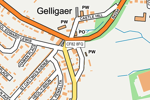
CF82 8FQ is located in the St Cattwg electoral ward, within the unitary authority of Caerphilly and the Welsh Parliamentary constituency of Caerphilly. The Local Health Board is Aneurin Bevan University and the police force is Gwent. This postcode has been in use since March 2012.


GetTheData
Source: OS OpenMap – Local (Ordnance Survey)
Source: OS VectorMap District (Ordnance Survey)
Licence: Open Government Licence (requires attribution)
| Easting | 313653 |
| Northing | 196830 |
| Latitude | 51.663595 |
| Longitude | -3.249834 |
GetTheData
Source: Open Postcode Geo
Licence: Open Government Licence
| Country | Wales |
| Postcode District | CF82 |
➜ See where CF82 is on a map ➜ Where is Gelligaer? | |
GetTheData
Source: Land Registry Price Paid Data
Licence: Open Government Licence
Elevation or altitude of CF82 8FQ as distance above sea level:
| Metres | Feet | |
|---|---|---|
| Elevation | 220m | 722ft |
Elevation is measured from the approximate centre of the postcode, to the nearest point on an OS contour line from OS Terrain 50, which has contour spacing of ten vertical metres.
➜ How high above sea level am I? Find the elevation of your current position using your device's GPS.
GetTheData
Source: Open Postcode Elevation
Licence: Open Government Licence
| Ward | St Cattwg |
| Constituency | Caerphilly |
GetTheData
Source: ONS Postcode Database
Licence: Open Government Licence
| Harp Inn (Church Road) | Gelligaer | 63m |
| Hampton Close (Penallta Road) | Gelligaer | 71m |
| Rectory (Church Road) | Gelligaer | 216m |
| Heol Cattwg | Gelligaer | 265m |
| Heol Cattwg | Gelligaer | 271m |
| Pengam Station | 1.6km |
| Hengoed Station | 2.5km |
| Ystrad Mynach Station | 2.6km |
GetTheData
Source: NaPTAN
Licence: Open Government Licence
GetTheData
Source: ONS Postcode Database
Licence: Open Government Licence


➜ Get more ratings from the Food Standards Agency
GetTheData
Source: Food Standards Agency
Licence: FSA terms & conditions
| Last Collection | |||
|---|---|---|---|
| Location | Mon-Fri | Sat | Distance |
| Glanynant Post Office | 16:15 | 11:00 | 1,648m |
| Fleur De Lys Village | 16:00 | 11:00 | 1,766m |
| Fleur De Lys Post Office | 17:00 | 12:00 | 1,944m |
GetTheData
Source: Dracos
Licence: Creative Commons Attribution-ShareAlike
The below table lists the International Territorial Level (ITL) codes (formerly Nomenclature of Territorial Units for Statistics (NUTS) codes) and Local Administrative Units (LAU) codes for CF82 8FQ:
| ITL 1 Code | Name |
|---|---|
| TLL | Wales |
| ITL 2 Code | Name |
| TLL1 | West Wales and The Valleys |
| ITL 3 Code | Name |
| TLL16 | Gwent Valleys |
| LAU 1 Code | Name |
| W06000018 | Caerphilly |
GetTheData
Source: ONS Postcode Directory
Licence: Open Government Licence
The below table lists the Census Output Area (OA), Lower Layer Super Output Area (LSOA), and Middle Layer Super Output Area (MSOA) for CF82 8FQ:
| Code | Name | |
|---|---|---|
| OA | W00007410 | |
| LSOA | W01001418 | Caerphilly 008E |
| MSOA | W02000297 | Caerphilly 008 |
GetTheData
Source: ONS Postcode Directory
Licence: Open Government Licence
| CF82 8HU | Hampton Close | 48m |
| CF82 8EE | South View Houses | 69m |
| CF82 8DY | Church Houses | 106m |
| CF82 8FA | Heol Penallta | 114m |
| CF82 8DZ | Castle Cottages | 129m |
| CF82 8EB | Chapel Cottages | 150m |
| CF82 8ED | Yew Tree Cottages | 161m |
| CF82 8FE | St Cattwgs Avenue | 203m |
| CF82 8FD | St Cattwgs Avenue | 207m |
| CF82 8FB | Heol Y Waun | 215m |
GetTheData
Source: Open Postcode Geo; Land Registry Price Paid Data
Licence: Open Government Licence