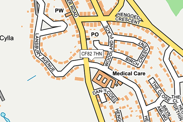
CF82 7HN is located in the Hengoed electoral ward, within the unitary authority of Caerphilly and the Welsh Parliamentary constituency of Caerphilly. The Local Health Board is Aneurin Bevan University and the police force is Gwent. This postcode has been in use since July 1995.


GetTheData
Source: OS OpenMap – Local (Ordnance Survey)
Source: OS VectorMap District (Ordnance Survey)
Licence: Open Government Licence (requires attribution)
| Easting | 314725 |
| Northing | 195720 |
| Latitude | 51.653780 |
| Longitude | -3.234067 |
GetTheData
Source: Open Postcode Geo
Licence: Open Government Licence
| Country | Wales |
| Postcode District | CF82 |
➜ See where CF82 is on a map ➜ Where is Ystrad Mynach? | |
GetTheData
Source: Land Registry Price Paid Data
Licence: Open Government Licence
Elevation or altitude of CF82 7HN as distance above sea level:
| Metres | Feet | |
|---|---|---|
| Elevation | 210m | 689ft |
Elevation is measured from the approximate centre of the postcode, to the nearest point on an OS contour line from OS Terrain 50, which has contour spacing of ten vertical metres.
➜ How high above sea level am I? Find the elevation of your current position using your device's GPS.
GetTheData
Source: Open Postcode Elevation
Licence: Open Government Licence
| Ward | Hengoed |
| Constituency | Caerphilly |
GetTheData
Source: ONS Postcode Database
Licence: Open Government Licence
| Cross Keys Inn (Gellygaer Road) | Cefn Hengoed | 21m |
| Cross Keys Inn (Gellygaer Road) | Cefn Hengoed | 71m |
| Lindsay Club (Gelligaer Road) | Cefn Hengoed | 335m |
| Lindsay Club (Gelligaer Road) | Cefn Hengoed | 344m |
| Primary School (Hengoed Road) | Hengoed | 349m |
| Hengoed Station | 1km |
| Ystrad Mynach Station | 1.5km |
| Pengam Station | 1.9km |
GetTheData
Source: NaPTAN
Licence: Open Government Licence
GetTheData
Source: ONS Postcode Database
Licence: Open Government Licence


➜ Get more ratings from the Food Standards Agency
GetTheData
Source: Food Standards Agency
Licence: FSA terms & conditions
| Last Collection | |||
|---|---|---|---|
| Location | Mon-Fri | Sat | Distance |
| Fleur De Lys Post Office | 17:00 | 12:00 | 1,209m |
| Maesycymmer Post Office | 17:00 | 11:15 | 1,375m |
| Fleur De Lys Village | 16:00 | 11:00 | 1,465m |
GetTheData
Source: Dracos
Licence: Creative Commons Attribution-ShareAlike
The below table lists the International Territorial Level (ITL) codes (formerly Nomenclature of Territorial Units for Statistics (NUTS) codes) and Local Administrative Units (LAU) codes for CF82 7HN:
| ITL 1 Code | Name |
|---|---|
| TLL | Wales |
| ITL 2 Code | Name |
| TLL1 | West Wales and The Valleys |
| ITL 3 Code | Name |
| TLL16 | Gwent Valleys |
| LAU 1 Code | Name |
| W06000018 | Caerphilly |
GetTheData
Source: ONS Postcode Directory
Licence: Open Government Licence
The below table lists the Census Output Area (OA), Lower Layer Super Output Area (LSOA), and Middle Layer Super Output Area (MSOA) for CF82 7HN:
| Code | Name | |
|---|---|---|
| OA | W00007150 | |
| LSOA | W01001364 | Caerphilly 012B |
| MSOA | W02000301 | Caerphilly 012 |
GetTheData
Source: ONS Postcode Directory
Licence: Open Government Licence
| CF82 7LL | Three Elms Close | 43m |
| CF82 7HF | Hengoed Crescent | 48m |
| CF82 7HW | Gelligaer Road | 58m |
| CF82 7HS | Derwendeg Avenue | 59m |
| CF82 7LH | Woodland Place | 100m |
| CF82 7HE | Lansbury Avenue | 110m |
| CF82 7HG | Hengoed Crescent | 142m |
| CF82 7LJ | Birch Crescent | 158m |
| CF82 7HR | Derwendeg Avenue | 163m |
| CF82 7HB | Lansbury Avenue | 174m |
GetTheData
Source: Open Postcode Geo; Land Registry Price Paid Data
Licence: Open Government Licence