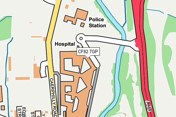
CF82 7GP is located in the Ystrad Mynach electoral ward, within the unitary authority of Caerphilly and the Welsh Parliamentary constituency of Caerphilly. The Local Health Board is Aneurin Bevan University and the police force is Gwent. This postcode has been in use since December 2011.


GetTheData
Source: OS OpenMap – Local (Ordnance Survey)
Source: OS VectorMap District (Ordnance Survey)
Licence: Open Government Licence (requires attribution)
| Easting | 314687 |
| Northing | 193649 |
| Latitude | 51.635155 |
| Longitude | -3.234100 |
GetTheData
Source: Open Postcode Geo
Licence: Open Government Licence
| Country | Wales |
| Postcode District | CF82 |
➜ See where CF82 is on a map ➜ Where is Ystrad Mynach? | |
GetTheData
Source: Land Registry Price Paid Data
Licence: Open Government Licence
Elevation or altitude of CF82 7GP as distance above sea level:
| Metres | Feet | |
|---|---|---|
| Elevation | 100m | 328ft |
Elevation is measured from the approximate centre of the postcode, to the nearest point on an OS contour line from OS Terrain 50, which has contour spacing of ten vertical metres.
➜ How high above sea level am I? Find the elevation of your current position using your device's GPS.
GetTheData
Source: Open Postcode Elevation
Licence: Open Government Licence
| Ward | Ystrad Mynach |
| Constituency | Caerphilly |
GetTheData
Source: ONS Postcode Database
Licence: Open Government Licence
| Hospital (Caerphilly Road) | Ystrad Mynach | 137m |
| Hospital (Caerphilly Road) | Ystrad Mynach | 147m |
| New Cottage Dance Centre (A472) | Ystrad Mynach | 320m |
| New Cottage Dance Centre (A472) | Ystrad Mynach | 341m |
| Coopers Arms (Caerphilly Road) | Ystrad Mynach | 364m |
| Ystrad Mynach Station | 0.8km |
| Hengoed Station | 1.5km |
| Llanbradach Station | 3.5km |
GetTheData
Source: NaPTAN
Licence: Open Government Licence
GetTheData
Source: ONS Postcode Database
Licence: Open Government Licence


➜ Get more ratings from the Food Standards Agency
GetTheData
Source: Food Standards Agency
Licence: FSA terms & conditions
| Last Collection | |||
|---|---|---|---|
| Location | Mon-Fri | Sat | Distance |
| Maesycymmer Post Office | 17:00 | 11:15 | 1,366m |
| Bryn Road | 16:15 | 11:15 | 2,664m |
| Fleur De Lys Post Office | 17:00 | 12:00 | 3,059m |
GetTheData
Source: Dracos
Licence: Creative Commons Attribution-ShareAlike
The below table lists the International Territorial Level (ITL) codes (formerly Nomenclature of Territorial Units for Statistics (NUTS) codes) and Local Administrative Units (LAU) codes for CF82 7GP:
| ITL 1 Code | Name |
|---|---|
| TLL | Wales |
| ITL 2 Code | Name |
| TLL1 | West Wales and The Valleys |
| ITL 3 Code | Name |
| TLL16 | Gwent Valleys |
| LAU 1 Code | Name |
| W06000018 | Caerphilly |
GetTheData
Source: ONS Postcode Directory
Licence: Open Government Licence
The below table lists the Census Output Area (OA), Lower Layer Super Output Area (LSOA), and Middle Layer Super Output Area (MSOA) for CF82 7GP:
| Code | Name | |
|---|---|---|
| OA | W00007496 | |
| LSOA | W01001434 | Caerphilly 013F |
| MSOA | W02000302 | Caerphilly 013 |
GetTheData
Source: ONS Postcode Directory
Licence: Open Government Licence
| CF82 7ER | Llanbradach Villas | 254m |
| CF82 7ET | Ynysglyd Street | 270m |
| CF82 7EQ | Coopers Terrace | 278m |
| CF82 7ES | Edward Street | 301m |
| CF82 7EP | Caerphilly Road | 310m |
| CF82 7FE | Ger Nant | 356m |
| CF82 7FG | Clos Tir Twyn | 383m |
| CF82 7EB | Commercial Street | 387m |
| CF82 7DY | Commercial Street | 439m |
| CF82 7DN | Stryd Hywel Harris | 443m |
GetTheData
Source: Open Postcode Geo; Land Registry Price Paid Data
Licence: Open Government Licence