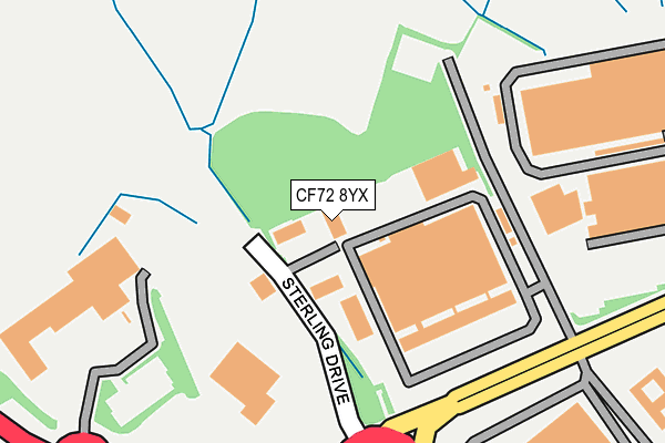
CF72 8YX lies on Sterling Drive in Llantrisant, Pontyclun. CF72 8YX is located in the Llantrisant and Talbot Green electoral ward, within the unitary authority of Rhondda Cynon Taf and the Welsh Parliamentary constituency of Pontypridd. The Local Health Board is Cwm Taf Morgannwg University and the police force is South Wales. This postcode has been in use since April 2010.


GetTheData
Source: OS OpenMap – Local (Ordnance Survey)
Source: OS VectorMap District (Ordnance Survey)
Licence: Open Government Licence (requires attribution)
| Easting | 303394 |
| Northing | 184816 |
| Latitude | 51.553932 |
| Longitude | -3.394803 |
GetTheData
Source: Open Postcode Geo
Licence: Open Government Licence
| Street | Sterling Drive |
| Locality | Llantrisant |
| Town/City | Pontyclun |
| Country | Wales |
| Postcode District | CF72 |
➜ See where CF72 is on a map ➜ Where is Llantrisant? | |
GetTheData
Source: Land Registry Price Paid Data
Licence: Open Government Licence
Elevation or altitude of CF72 8YX as distance above sea level:
| Metres | Feet | |
|---|---|---|
| Elevation | 70m | 230ft |
Elevation is measured from the approximate centre of the postcode, to the nearest point on an OS contour line from OS Terrain 50, which has contour spacing of ten vertical metres.
➜ How high above sea level am I? Find the elevation of your current position using your device's GPS.
GetTheData
Source: Open Postcode Elevation
Licence: Open Government Licence
| Ward | Llantrisant And Talbot Green |
| Constituency | Pontypridd |
GetTheData
Source: ONS Postcode Database
Licence: Open Government Licence
| Industrial Estate (Ely Valley Road) | Ynysmaerdy | 202m |
| Industrial Estate (Ely Valley Road) | Ynysmaerdy | 241m |
| Dyffryn Isaf (Ely Valley Road) | Ynysmaerdy | 631m |
| Royal Glamorgan Hospital (Grounds) | Ynysmaerdy | 652m |
| Royal Glamorgan Hospital (Grounds) | Ynysmaerdy | 656m |
| Pontyclun Station | 3.4km |
| Llanharan Station | 3.7km |
| Pontypridd Station | 6.3km |
GetTheData
Source: NaPTAN
Licence: Open Government Licence
GetTheData
Source: ONS Postcode Database
Licence: Open Government Licence


➜ Get more ratings from the Food Standards Agency
GetTheData
Source: Food Standards Agency
Licence: FSA terms & conditions
| Last Collection | |||
|---|---|---|---|
| Location | Mon-Fri | Sat | Distance |
| Gelli | 17:15 | 11:30 | 2,965m |
| Gwaunmiskin Beddau | 18:00 | 11:45 | 3,055m |
| Brynna Post Office | 16:45 | 11:45 | 3,152m |
GetTheData
Source: Dracos
Licence: Creative Commons Attribution-ShareAlike
The below table lists the International Territorial Level (ITL) codes (formerly Nomenclature of Territorial Units for Statistics (NUTS) codes) and Local Administrative Units (LAU) codes for CF72 8YX:
| ITL 1 Code | Name |
|---|---|
| TLL | Wales |
| ITL 2 Code | Name |
| TLL1 | West Wales and The Valleys |
| ITL 3 Code | Name |
| TLL15 | Central Valleys |
| LAU 1 Code | Name |
| W06000016 | Rhondda Cynon Taf |
GetTheData
Source: ONS Postcode Directory
Licence: Open Government Licence
The below table lists the Census Output Area (OA), Lower Layer Super Output Area (LSOA), and Middle Layer Super Output Area (MSOA) for CF72 8YX:
| Code | Name | |
|---|---|---|
| OA | W00006291 | |
| LSOA | W01001195 | Rhondda Cynon Taf 030C |
| MSOA | W02000281 | Rhondda Cynon Taf 030 |
GetTheData
Source: ONS Postcode Directory
Licence: Open Government Licence
| CF72 8LG | Ynysmaerdy Terrace | 323m |
| CF72 8LJ | Glan Yr Ely | 380m |
| CF72 8LN | Ely Valley Road | 393m |
| CF72 8LH | Pembroke Crescent | 406m |
| CF72 9JZ | Forest View | 769m |
| CF72 8LF | Llantrisant Business Park | 949m |
| CF72 8LL | Ely Valley Road | 1047m |
| CF72 8LP | 1422m | |
| CF72 8EJ | Police Houses | 1532m |
| CF72 8EL | Coed Yr Esgob | 1555m |
GetTheData
Source: Open Postcode Geo; Land Registry Price Paid Data
Licence: Open Government Licence