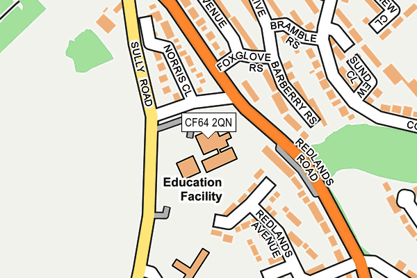
CF64 2QN is located in the Cornerswell electoral ward, within the unitary authority of Vale of Glamorgan and the Welsh Parliamentary constituency of Cardiff South and Penarth. The Local Health Board is Cardiff and Vale University and the police force is South Wales. This postcode has been in use since January 1993.


GetTheData
Source: OS OpenMap – Local (Ordnance Survey)
Source: OS VectorMap District (Ordnance Survey)
Licence: Open Government Licence (requires attribution)
| Easting | 316959 |
| Northing | 172028 |
| Latitude | 51.441135 |
| Longitude | -3.196172 |
GetTheData
Source: Open Postcode Geo
Licence: Open Government Licence
| Country | Wales |
| Postcode District | CF64 |
➜ See where CF64 is on a map ➜ Where is Penarth? | |
GetTheData
Source: Land Registry Price Paid Data
Licence: Open Government Licence
Elevation or altitude of CF64 2QN as distance above sea level:
| Metres | Feet | |
|---|---|---|
| Elevation | 40m | 131ft |
Elevation is measured from the approximate centre of the postcode, to the nearest point on an OS contour line from OS Terrain 50, which has contour spacing of ten vertical metres.
➜ How high above sea level am I? Find the elevation of your current position using your device's GPS.
GetTheData
Source: Open Postcode Elevation
Licence: Open Government Licence
| Ward | Cornerswell |
| Constituency | Cardiff South And Penarth |
GetTheData
Source: ONS Postcode Database
Licence: Open Government Licence
| Cowslip (Redlands Road) | Cogan Pill | 78m |
| Foxglove Rise | Cogan Pill | 117m |
| Foxglove Rise | Cogan Pill | 123m |
| The Cowslip (Redlands Road) | Cogan Pill | 149m |
| Bramble Rise | Cogan Pill | 193m |
| Cogan Station | 0.7km |
| Eastbrook Station | 0.8km |
| Dingle Road Station | 1.1km |
GetTheData
Source: NaPTAN
Licence: Open Government Licence
GetTheData
Source: ONS Postcode Database
Licence: Open Government Licence


➜ Get more ratings from the Food Standards Agency
GetTheData
Source: Food Standards Agency
Licence: FSA terms & conditions
| Last Collection | |||
|---|---|---|---|
| Location | Mon-Fri | Sat | Distance |
| Georges Row | 16:00 | 11:00 | 680m |
| Meadowside | 16:00 | 11:00 | 703m |
| Tennyson Road Post Office | 17:15 | 12:00 | 740m |
GetTheData
Source: Dracos
Licence: Creative Commons Attribution-ShareAlike
The below table lists the International Territorial Level (ITL) codes (formerly Nomenclature of Territorial Units for Statistics (NUTS) codes) and Local Administrative Units (LAU) codes for CF64 2QN:
| ITL 1 Code | Name |
|---|---|
| TLL | Wales |
| ITL 2 Code | Name |
| TLL2 | East Wales |
| ITL 3 Code | Name |
| TLL22 | Cardiff and Vale of Glamorgan |
| LAU 1 Code | Name |
| W06000014 | Vale of Glamorgan |
GetTheData
Source: ONS Postcode Directory
Licence: Open Government Licence
The below table lists the Census Output Area (OA), Lower Layer Super Output Area (LSOA), and Middle Layer Super Output Area (MSOA) for CF64 2QN:
| Code | Name | |
|---|---|---|
| OA | W00005700 | |
| LSOA | W01001077 | The Vale of Glamorgan 004C |
| MSOA | W02000240 | The Vale of Glamorgan 004 |
GetTheData
Source: ONS Postcode Directory
Licence: Open Government Licence
| CF64 2RJ | Flax Court | 93m |
| CF64 2QW | Norris Close | 130m |
| CF64 2QH | Penyturnpike View | 137m |
| CF64 2RB | Barberry Rise | 147m |
| CF64 2QU | Redlands Avenue | 156m |
| CF64 2QS | Redlands Road | 165m |
| CF64 2RE | Bramble Rise | 183m |
| CF64 2QQ | Redlands Road | 188m |
| CF64 2QZ | Heath Avenue | 221m |
| CF64 2RH | Cowslip Drive | 225m |
GetTheData
Source: Open Postcode Geo; Land Registry Price Paid Data
Licence: Open Government Licence