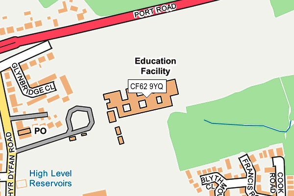
CF62 9YQ is located in the Gibbonsdown electoral ward, within the unitary authority of Vale of Glamorgan and the Welsh Parliamentary constituency of Vale of Glamorgan. The Local Health Board is Cardiff and Vale University and the police force is South Wales. This postcode has been in use since January 1993.


GetTheData
Source: OS OpenMap – Local (Ordnance Survey)
Source: OS VectorMap District (Ordnance Survey)
Licence: Open Government Licence (requires attribution)
| Easting | 311985 |
| Northing | 170281 |
| Latitude | 51.424678 |
| Longitude | -3.267284 |
GetTheData
Source: Open Postcode Geo
Licence: Open Government Licence
| Country | Wales |
| Postcode District | CF62 |
➜ See where CF62 is on a map ➜ Where is Barry? | |
GetTheData
Source: Land Registry Price Paid Data
Licence: Open Government Licence
Elevation or altitude of CF62 9YQ as distance above sea level:
| Metres | Feet | |
|---|---|---|
| Elevation | 80m | 262ft |
Elevation is measured from the approximate centre of the postcode, to the nearest point on an OS contour line from OS Terrain 50, which has contour spacing of ten vertical metres.
➜ How high above sea level am I? Find the elevation of your current position using your device's GPS.
GetTheData
Source: Open Postcode Elevation
Licence: Open Government Licence
| Ward | Gibbonsdown |
| Constituency | Vale Of Glamorgan |
GetTheData
Source: ONS Postcode Database
Licence: Open Government Licence
| Merthyr Dyfan Road (Port Road East) | Merthyr Dyfan | 266m |
| Merthyr Dyfan Road (Port Road East) | Merthyr Dyfan | 393m |
| Magellan Close (Skomer Road) | Gibbonsdown | 408m |
| Barry Rugby Club (Merthyr Dyfan Road) | Merthyr Dyfan | 409m |
| Barry Rugby Club (Merthyr Dyfan Road) | Merthyr Dyfan | 418m |
| Cadoxton Station | 1.9km |
| Barry Docks Station | 2.5km |
| Barry Station | 3.3km |
GetTheData
Source: NaPTAN
Licence: Open Government Licence
GetTheData
Source: ONS Postcode Database
Licence: Open Government Licence


➜ Get more ratings from the Food Standards Agency
GetTheData
Source: Food Standards Agency
Licence: FSA terms & conditions
| Last Collection | |||
|---|---|---|---|
| Location | Mon-Fri | Sat | Distance |
| Stumpy Lodge | 17:00 | 12:00 | 625m |
| Seaview Terrace | 17:00 | 12:00 | 1,634m |
| 3-5 Holton Road | 19:00 | 12:30 | 1,823m |
GetTheData
Source: Dracos
Licence: Creative Commons Attribution-ShareAlike
The below table lists the International Territorial Level (ITL) codes (formerly Nomenclature of Territorial Units for Statistics (NUTS) codes) and Local Administrative Units (LAU) codes for CF62 9YQ:
| ITL 1 Code | Name |
|---|---|
| TLL | Wales |
| ITL 2 Code | Name |
| TLL2 | East Wales |
| ITL 3 Code | Name |
| TLL22 | Cardiff and Vale of Glamorgan |
| LAU 1 Code | Name |
| W06000014 | Vale of Glamorgan |
GetTheData
Source: ONS Postcode Directory
Licence: Open Government Licence
The below table lists the Census Output Area (OA), Lower Layer Super Output Area (LSOA), and Middle Layer Super Output Area (MSOA) for CF62 9YQ:
| Code | Name | |
|---|---|---|
| OA | W00005796 | |
| LSOA | W01001097 | The Vale of Glamorgan 007F |
| MSOA | W02000243 | The Vale of Glamorgan 007 |
GetTheData
Source: ONS Postcode Directory
Licence: Open Government Licence
| CF62 9HG | Blyth Close | 185m |
| CF62 9FN | Glynbridge Close | 210m |
| CF62 9UA | Merthyr Dyfan Court | 220m |
| CF62 9XS | Port Mews | 249m |
| CF62 9HH | Francis Road | 264m |
| CF62 9HF | Mountbatten Road | 284m |
| CF62 9TG | Merthyr Dyfan Road | 314m |
| CF62 9PX | Port Road East | 317m |
| CF62 9HD | Cook Road | 327m |
| CF62 9HJ | Hardy Close | 355m |
GetTheData
Source: Open Postcode Geo; Land Registry Price Paid Data
Licence: Open Government Licence