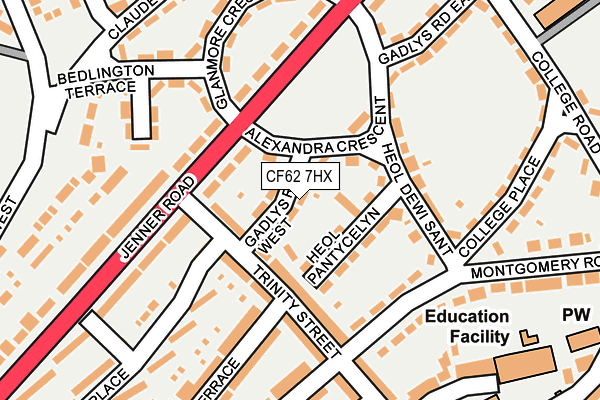
CF62 7HX lies on Gadlys Road West in Barry. CF62 7HX is located in the Buttrills electoral ward, within the unitary authority of Vale of Glamorgan and the Welsh Parliamentary constituency of Vale of Glamorgan. The Local Health Board is Cardiff and Vale University and the police force is South Wales. This postcode has been in use since January 1993.


GetTheData
Source: OS OpenMap – Local (Ordnance Survey)
Source: OS VectorMap District (Ordnance Survey)
Licence: Open Government Licence (requires attribution)
| Easting | 310902 |
| Northing | 168018 |
| Latitude | 51.404166 |
| Longitude | -3.282287 |
GetTheData
Source: Open Postcode Geo
Licence: Open Government Licence
| Street | Gadlys Road West |
| Town/City | Barry |
| Country | Wales |
| Postcode District | CF62 |
➜ See where CF62 is on a map ➜ Where is Barry? | |
GetTheData
Source: Land Registry Price Paid Data
Licence: Open Government Licence
Elevation or altitude of CF62 7HX as distance above sea level:
| Metres | Feet | |
|---|---|---|
| Elevation | 70m | 230ft |
Elevation is measured from the approximate centre of the postcode, to the nearest point on an OS contour line from OS Terrain 50, which has contour spacing of ten vertical metres.
➜ How high above sea level am I? Find the elevation of your current position using your device's GPS.
GetTheData
Source: Open Postcode Elevation
Licence: Open Government Licence
| Ward | Buttrills |
| Constituency | Vale Of Glamorgan |
GetTheData
Source: ONS Postcode Database
Licence: Open Government Licence
| Alexandra Gardens (Jenner Road) | Barry | 95m |
| Alexandra Gardens (Jenner Road) | Barry | 105m |
| Montgomery Road | Barry | 144m |
| Montgomery Road | Barry | 165m |
| Porthkerry Road | Barry | 261m |
| Barry Station | 0.8km |
| Barry Island Station | 1.4km |
| Barry Docks Station | 1.5km |
GetTheData
Source: NaPTAN
Licence: Open Government Licence
| Percentage of properties with Next Generation Access | 100.0% |
| Percentage of properties with Superfast Broadband | 100.0% |
| Percentage of properties with Ultrafast Broadband | 100.0% |
| Percentage of properties with Full Fibre Broadband | 0.0% |
Superfast Broadband is between 30Mbps and 300Mbps
Ultrafast Broadband is > 300Mbps
| Median download speed | 73.8Mbps |
| Average download speed | 68.4Mbps |
| Maximum download speed | 100.00Mbps |
| Median upload speed | 12.4Mbps |
| Average upload speed | 12.2Mbps |
| Maximum upload speed | 19.64Mbps |
| Percentage of properties unable to receive 2Mbps | 0.0% |
| Percentage of properties unable to receive 5Mbps | 0.0% |
| Percentage of properties unable to receive 10Mbps | 0.0% |
| Percentage of properties unable to receive 30Mbps | 0.0% |
GetTheData
Source: Ofcom
Licence: Ofcom Terms of Use (requires attribution)
Estimated total energy consumption in CF62 7HX by fuel type, 2015.
| Consumption (kWh) | 166,869 |
|---|---|
| Meter count | 15 |
| Mean (kWh/meter) | 11,125 |
| Median (kWh/meter) | 12,465 |
| Consumption (kWh) | 36,284 |
|---|---|
| Meter count | 14 |
| Mean (kWh/meter) | 2,592 |
| Median (kWh/meter) | 2,676 |
GetTheData
Source: Postcode level gas estimates: 2015 (experimental)
Source: Postcode level electricity estimates: 2015 (experimental)
Licence: Open Government Licence
GetTheData
Source: ONS Postcode Database
Licence: Open Government Licence


➜ Get more ratings from the Food Standards Agency
GetTheData
Source: Food Standards Agency
Licence: FSA terms & conditions
| Last Collection | |||
|---|---|---|---|
| Location | Mon-Fri | Sat | Distance |
| Colcot Road South | 17:00 | 12:00 | 694m |
| Park Road | 17:00 | 12:00 | 764m |
| Ffordd Y Mileniwm | 17:30 | 12:15 | 787m |
GetTheData
Source: Dracos
Licence: Creative Commons Attribution-ShareAlike
The below table lists the International Territorial Level (ITL) codes (formerly Nomenclature of Territorial Units for Statistics (NUTS) codes) and Local Administrative Units (LAU) codes for CF62 7HX:
| ITL 1 Code | Name |
|---|---|
| TLL | Wales |
| ITL 2 Code | Name |
| TLL2 | East Wales |
| ITL 3 Code | Name |
| TLL22 | Cardiff and Vale of Glamorgan |
| LAU 1 Code | Name |
| W06000014 | Vale of Glamorgan |
GetTheData
Source: ONS Postcode Directory
Licence: Open Government Licence
The below table lists the Census Output Area (OA), Lower Layer Super Output Area (LSOA), and Middle Layer Super Output Area (MSOA) for CF62 7HX:
| Code | Name | |
|---|---|---|
| OA | W00005643 | |
| LSOA | W01001064 | The Vale of Glamorgan 013B |
| MSOA | W02000249 | The Vale of Glamorgan 013 |
GetTheData
Source: ONS Postcode Directory
Licence: Open Government Licence
| CF62 7BZ | Heol Pantycelyn | 48m |
| CF62 7EX | Trinity Street | 65m |
| CF62 7HP | Jenner Road | 78m |
| CF62 7BY | Heol Dewi Sant | 118m |
| CF62 7HJ | Jenner Road | 119m |
| CF62 7EW | Trinity Street | 121m |
| CF62 7HH | Jenner Road | 148m |
| CF62 7HT | Alexandra Crescent | 150m |
| CF62 7DB | Montgomery Road | 169m |
| CF62 7HQ | Jenner Road | 172m |
GetTheData
Source: Open Postcode Geo; Land Registry Price Paid Data
Licence: Open Government Licence