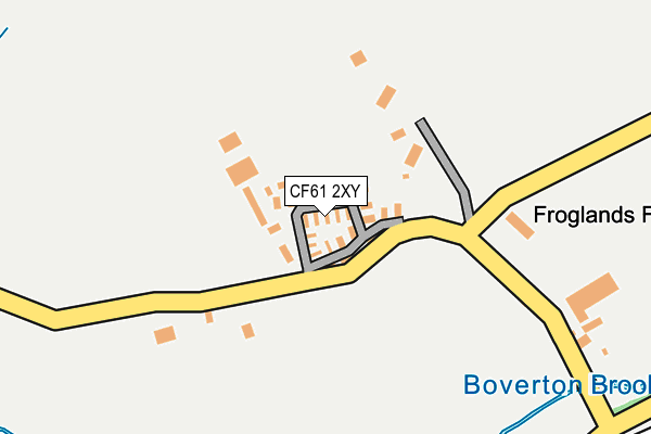
CF61 2XY is located in the Llantwit Major electoral ward, within the unitary authority of Vale of Glamorgan and the Welsh Parliamentary constituency of Vale of Glamorgan. The Local Health Board is Cardiff and Vale University and the police force is South Wales. This postcode has been in use since December 1998.


GetTheData
Source: OS OpenMap – Local (Ordnance Survey)
Source: OS VectorMap District (Ordnance Survey)
Licence: Open Government Licence (requires attribution)
| Easting | 298818 |
| Northing | 169239 |
| Latitude | 51.413112 |
| Longitude | -3.456302 |
GetTheData
Source: Open Postcode Geo
Licence: Open Government Licence
| Country | Wales |
| Postcode District | CF61 |
➜ See where CF61 is on a map | |
GetTheData
Source: Land Registry Price Paid Data
Licence: Open Government Licence
Elevation or altitude of CF61 2XY as distance above sea level:
| Metres | Feet | |
|---|---|---|
| Elevation | 40m | 131ft |
Elevation is measured from the approximate centre of the postcode, to the nearest point on an OS contour line from OS Terrain 50, which has contour spacing of ten vertical metres.
➜ How high above sea level am I? Find the elevation of your current position using your device's GPS.
GetTheData
Source: Open Postcode Elevation
Licence: Open Government Licence
| Ward | Llantwit Major |
| Constituency | Vale Of Glamorgan |
GetTheData
Source: ONS Postcode Database
Licence: Open Government Licence
| North Gate (Eglwys Brewis Road) | Boverton | 382m |
| North Gate (Eglwys Brewis Road) | Boverton | 398m |
| Old Brewery (Eglwys Brewis Road) | Boverton | 525m |
| Old Brewery (Eglwys Brewis Road) | Boverton | 541m |
| Woodpecker Square | Boverton | 596m |
| Llantwit Major Station | 1.8km |
GetTheData
Source: NaPTAN
Licence: Open Government Licence
| Median download speed | 20.3Mbps |
| Average download speed | 18.5Mbps |
| Maximum download speed | 35.45Mbps |
| Median upload speed | 2.3Mbps |
| Average upload speed | 2.2Mbps |
| Maximum upload speed | 4.24Mbps |
GetTheData
Source: Ofcom
Licence: Ofcom Terms of Use (requires attribution)
GetTheData
Source: ONS Postcode Database
Licence: Open Government Licence


➜ Get more ratings from the Food Standards Agency
GetTheData
Source: Food Standards Agency
Licence: FSA terms & conditions
| Last Collection | |||
|---|---|---|---|
| Location | Mon-Fri | Sat | Distance |
| Boverton Post Office | 16:45 | 11:45 | 982m |
| Boverton Road | 16:45 | 11:15 | 1,784m |
| Caer Worgan | 16:15 | 11:15 | 1,891m |
GetTheData
Source: Dracos
Licence: Creative Commons Attribution-ShareAlike
The below table lists the International Territorial Level (ITL) codes (formerly Nomenclature of Territorial Units for Statistics (NUTS) codes) and Local Administrative Units (LAU) codes for CF61 2XY:
| ITL 1 Code | Name |
|---|---|
| TLL | Wales |
| ITL 2 Code | Name |
| TLL2 | East Wales |
| ITL 3 Code | Name |
| TLL22 | Cardiff and Vale of Glamorgan |
| LAU 1 Code | Name |
| W06000014 | Vale of Glamorgan |
GetTheData
Source: ONS Postcode Directory
Licence: Open Government Licence
The below table lists the Census Output Area (OA), Lower Layer Super Output Area (LSOA), and Middle Layer Super Output Area (MSOA) for CF61 2XY:
| Code | Name | |
|---|---|---|
| OA | W00005843 | |
| LSOA | W01001108 | The Vale of Glamorgan 014A |
| MSOA | W02000250 | The Vale of Glamorgan 014 |
GetTheData
Source: ONS Postcode Directory
Licence: Open Government Licence
| CF62 4AB | Eagle Terrace | 358m |
| CF62 4NR | Eagle Road | 361m |
| CF62 4NE | Partridge Road | 450m |
| CF62 4NF | Partridge Road | 515m |
| CF62 4ND | Bullfinch Road | 566m |
| CF61 2AT | Church Meadow | 589m |
| CF62 4NQ | Magpie Road | 676m |
| CF62 4NL | Blackbird Road | 710m |
| CF62 4NJ | Starling Road | 712m |
| CF61 2GS | Heol Merioneth | 743m |
GetTheData
Source: Open Postcode Geo; Land Registry Price Paid Data
Licence: Open Government Licence