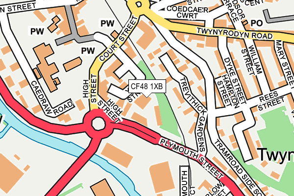
CF48 1XB is located in the Town electoral ward, within the unitary authority of Merthyr Tydfil and the Welsh Parliamentary constituency of Merthyr Tydfil and Rhymney. The Local Health Board is Cwm Taf Morgannwg University and the police force is South Wales. This postcode has been in use since June 2001.


GetTheData
Source: OS OpenMap – Local (Ordnance Survey)
Source: OS VectorMap District (Ordnance Survey)
Licence: Open Government Licence (requires attribution)
| Easting | 305104 |
| Northing | 205741 |
| Latitude | 51.742308 |
| Longitude | -3.375818 |
GetTheData
Source: Open Postcode Geo
Licence: Open Government Licence
| Country | Wales |
| Postcode District | CF48 |
➜ See where CF48 is on a map ➜ Where is Merthyr Tydfil? | |
GetTheData
Source: Land Registry Price Paid Data
Licence: Open Government Licence
Elevation or altitude of CF48 1XB as distance above sea level:
| Metres | Feet | |
|---|---|---|
| Elevation | 170m | 558ft |
Elevation is measured from the approximate centre of the postcode, to the nearest point on an OS contour line from OS Terrain 50, which has contour spacing of ten vertical metres.
➜ How high above sea level am I? Find the elevation of your current position using your device's GPS.
GetTheData
Source: Open Postcode Elevation
Licence: Open Government Licence
| Ward | Town |
| Constituency | Merthyr Tydfil And Rhymney |
GetTheData
Source: ONS Postcode Database
Licence: Open Government Licence
| Castle Bingo (Plymouth Street) | Merthyr Tydfil | 69m |
| Castle Bingo (Plymouth Street) | Merthyr Tydfil | 72m |
| Seion (Ttwynyrodyn Road) | Twynyrodyn | 182m |
| White Horse (Windsor Terrace) | Twynyrodyn | 241m |
| Warlow Street (Plymouth Street) | Merthyr Tydfil | 251m |
| Merthyr Tydfil Station | 0.3km |
| Pentre-Bach Station | 2.1km |
| Troed-y-Rhiw Station | 3.9km |
GetTheData
Source: NaPTAN
Licence: Open Government Licence
GetTheData
Source: ONS Postcode Database
Licence: Open Government Licence


➜ Get more ratings from the Food Standards Agency
GetTheData
Source: Food Standards Agency
Licence: FSA terms & conditions
| Last Collection | |||
|---|---|---|---|
| Location | Mon-Fri | Sat | Distance |
| Pentrebach | 16:45 | 12:00 | 70m |
| Twyn Y Rodyn | 17:00 | 12:00 | 220m |
| Mountain Air | 17:00 | 11:30 | 274m |
GetTheData
Source: Dracos
Licence: Creative Commons Attribution-ShareAlike
The below table lists the International Territorial Level (ITL) codes (formerly Nomenclature of Territorial Units for Statistics (NUTS) codes) and Local Administrative Units (LAU) codes for CF48 1XB:
| ITL 1 Code | Name |
|---|---|
| TLL | Wales |
| ITL 2 Code | Name |
| TLL1 | West Wales and The Valleys |
| ITL 3 Code | Name |
| TLL15 | Central Valleys |
| LAU 1 Code | Name |
| W06000024 | Merthyr Tydfil |
GetTheData
Source: ONS Postcode Directory
Licence: Open Government Licence
The below table lists the Census Output Area (OA), Lower Layer Super Output Area (LSOA), and Middle Layer Super Output Area (MSOA) for CF48 1XB:
| Code | Name | |
|---|---|---|
| OA | W00006893 | |
| LSOA | W01001315 | Merthyr Tydfil 004D |
| MSOA | W02000286 | Merthyr Tydfil 004 |
GetTheData
Source: ONS Postcode Directory
Licence: Open Government Licence
| CF47 8EB | Lower High Street | 76m |
| CF47 0RP | Trevithick Gardens | 87m |
| CF47 8DU | Court Street | 123m |
| CF47 8HR | Morlais Court | 134m |
| CF47 0SL | Catherines Court | 137m |
| CF47 0SG | Davies Terrace | 143m |
| CF47 0RR | Hampton Street | 151m |
| CF47 0SE | Bryn Seion Cottages | 155m |
| CF47 0SD | Twynyrodyn Road | 162m |
| CF47 0RW | Tramroadside South | 164m |
GetTheData
Source: Open Postcode Geo; Land Registry Price Paid Data
Licence: Open Government Licence