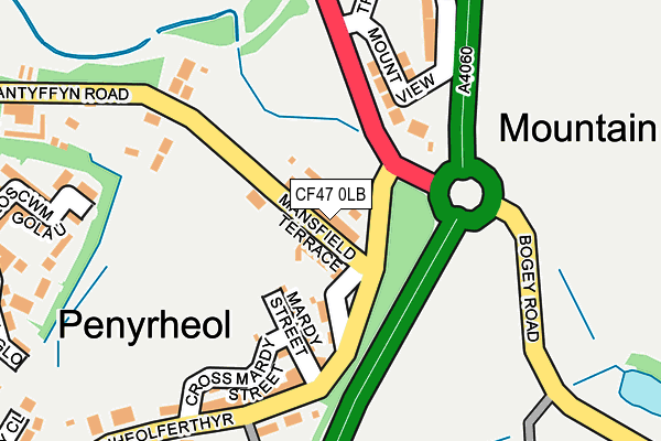
CF47 0LB lies on Mansfield Terrace in Merthyr Tydfil. CF47 0LB is located in the Town electoral ward, within the unitary authority of Merthyr Tydfil and the Welsh Parliamentary constituency of Merthyr Tydfil and Rhymney. The Local Health Board is Cwm Taf Morgannwg University and the police force is South Wales. This postcode has been in use since January 1980.


GetTheData
Source: OS OpenMap – Local (Ordnance Survey)
Source: OS VectorMap District (Ordnance Survey)
Licence: Open Government Licence (requires attribution)
| Easting | 306201 |
| Northing | 206191 |
| Latitude | 51.746538 |
| Longitude | -3.360057 |
GetTheData
Source: Open Postcode Geo
Licence: Open Government Licence
| Street | Mansfield Terrace |
| Town/City | Merthyr Tydfil |
| Country | Wales |
| Postcode District | CF47 |
➜ See where CF47 is on a map ➜ Where is Merthyr Tydfil? | |
GetTheData
Source: Land Registry Price Paid Data
Licence: Open Government Licence
Elevation or altitude of CF47 0LB as distance above sea level:
| Metres | Feet | |
|---|---|---|
| Elevation | 270m | 886ft |
Elevation is measured from the approximate centre of the postcode, to the nearest point on an OS contour line from OS Terrain 50, which has contour spacing of ten vertical metres.
➜ How high above sea level am I? Find the elevation of your current position using your device's GPS.
GetTheData
Source: Open Postcode Elevation
Licence: Open Government Licence
| Ward | Town |
| Constituency | Merthyr Tydfil And Rhymney |
GetTheData
Source: ONS Postcode Database
Licence: Open Government Licence
| Mansfield Terrace | Mountain Hare | 9m |
| Mansfield Terrace | Mountain Hare | 33m |
| Farmers Arms (Penheolferthyr) | Mountain Hare | 154m |
| Farmers Arms (Penheolferthyr) | Mountain Hare | 169m |
| Incline Bridge (Wallhead Road) | Twynyrodyn | 451m |
| Merthyr Tydfil Station | 1.2km |
| Pentre-Bach Station | 2.4km |
| Troed-y-Rhiw Station | 3.9km |
GetTheData
Source: NaPTAN
Licence: Open Government Licence
| Percentage of properties with Next Generation Access | 100.0% |
| Percentage of properties with Superfast Broadband | 100.0% |
| Percentage of properties with Ultrafast Broadband | 0.0% |
| Percentage of properties with Full Fibre Broadband | 0.0% |
Superfast Broadband is between 30Mbps and 300Mbps
Ultrafast Broadband is > 300Mbps
| Median download speed | 9.9Mbps |
| Average download speed | 17.0Mbps |
| Maximum download speed | 55.00Mbps |
| Median upload speed | 1.1Mbps |
| Average upload speed | 3.1Mbps |
| Maximum upload speed | 10.00Mbps |
| Percentage of properties unable to receive 2Mbps | 0.0% |
| Percentage of properties unable to receive 5Mbps | 0.0% |
| Percentage of properties unable to receive 10Mbps | 0.0% |
| Percentage of properties unable to receive 30Mbps | 0.0% |
GetTheData
Source: Ofcom
Licence: Ofcom Terms of Use (requires attribution)
Estimated total energy consumption in CF47 0LB by fuel type, 2015.
| Consumption (kWh) | 242,712 |
|---|---|
| Meter count | 19 |
| Mean (kWh/meter) | 12,774 |
| Median (kWh/meter) | 12,343 |
| Consumption (kWh) | 105,214 |
|---|---|
| Meter count | 22 |
| Mean (kWh/meter) | 4,782 |
| Median (kWh/meter) | 3,855 |
GetTheData
Source: Postcode level gas estimates: 2015 (experimental)
Source: Postcode level electricity estimates: 2015 (experimental)
Licence: Open Government Licence
GetTheData
Source: ONS Postcode Database
Licence: Open Government Licence


➜ Get more ratings from the Food Standards Agency
GetTheData
Source: Food Standards Agency
Licence: FSA terms & conditions
| Last Collection | |||
|---|---|---|---|
| Location | Mon-Fri | Sat | Distance |
| Twyn Y Rodyn | 17:00 | 12:00 | 1,223m |
| Pentrebach | 16:45 | 12:00 | 1,256m |
| Kier Hardie Estate | 17:15 | 11:45 | 1,278m |
GetTheData
Source: Dracos
Licence: Creative Commons Attribution-ShareAlike
The below table lists the International Territorial Level (ITL) codes (formerly Nomenclature of Territorial Units for Statistics (NUTS) codes) and Local Administrative Units (LAU) codes for CF47 0LB:
| ITL 1 Code | Name |
|---|---|
| TLL | Wales |
| ITL 2 Code | Name |
| TLL1 | West Wales and The Valleys |
| ITL 3 Code | Name |
| TLL15 | Central Valleys |
| LAU 1 Code | Name |
| W06000024 | Merthyr Tydfil |
GetTheData
Source: ONS Postcode Directory
Licence: Open Government Licence
The below table lists the Census Output Area (OA), Lower Layer Super Output Area (LSOA), and Middle Layer Super Output Area (MSOA) for CF47 0LB:
| Code | Name | |
|---|---|---|
| OA | W00006889 | |
| LSOA | W01001316 | Merthyr Tydfil 005B |
| MSOA | W02000287 | Merthyr Tydfil 005 |
GetTheData
Source: ONS Postcode Directory
Licence: Open Government Licence
| CF47 0LD | Mardy Street | 100m |
| CF47 0LE | Cross Mardy Street | 129m |
| CF47 0UX | Mount View | 157m |
| CF47 0LF | Penheol Ferthyr | 165m |
| CF47 0LG | Bryn Terrace | 193m |
| CF47 0LH | 243m | |
| CF47 0JA | Clos Cwm Golau | 280m |
| CF47 0JE | Glyn Teg | 282m |
| CF47 0JF | Clos Pwll Glo | 308m |
| CF47 0LX | Cedar Close | 321m |
GetTheData
Source: Open Postcode Geo; Land Registry Price Paid Data
Licence: Open Government Licence