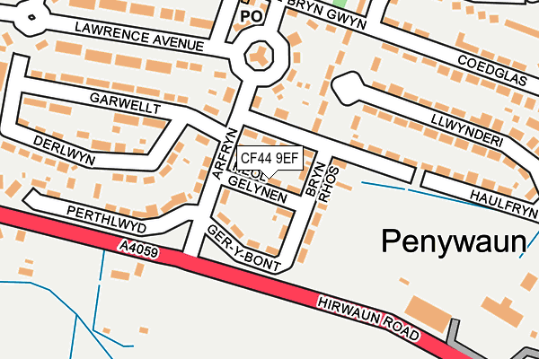
CF44 9EF lies on Heol Gelynen in Aberdare. CF44 9EF is located in the Pen-y-waun electoral ward, within the unitary authority of Rhondda Cynon Taf and the Welsh Parliamentary constituency of Cynon Valley. The Local Health Board is Cwm Taf Morgannwg University and the police force is South Wales. This postcode has been in use since January 1980.


GetTheData
Source: OS OpenMap – Local (Ordnance Survey)
Source: OS VectorMap District (Ordnance Survey)
Licence: Open Government Licence (requires attribution)
| Easting | 297414 |
| Northing | 204679 |
| Latitude | 51.731406 |
| Longitude | -3.486844 |
GetTheData
Source: Open Postcode Geo
Licence: Open Government Licence
| Street | Heol Gelynen |
| Town/City | Aberdare |
| Country | Wales |
| Postcode District | CF44 |
➜ See where CF44 is on a map ➜ Where is Aberdare? | |
GetTheData
Source: Land Registry Price Paid Data
Licence: Open Government Licence
Elevation or altitude of CF44 9EF as distance above sea level:
| Metres | Feet | |
|---|---|---|
| Elevation | 200m | 656ft |
Elevation is measured from the approximate centre of the postcode, to the nearest point on an OS contour line from OS Terrain 50, which has contour spacing of ten vertical metres.
➜ How high above sea level am I? Find the elevation of your current position using your device's GPS.
GetTheData
Source: Open Postcode Elevation
Licence: Open Government Licence
| Ward | Pen-y-waun |
| Constituency | Cynon Valley |
GetTheData
Source: ONS Postcode Database
Licence: Open Government Licence
| Haulfryn (Arfryn) | Pen-y-waun | 65m |
| Garwellt (Arfryn) | Pen-y-waun | 74m |
| Bryncoed (Heol Bryn Gwyn) | Pen-y-waun | 200m |
| Bryncoed (Heol Bryn Gwyn) | Pen-y-waun | 200m |
| Perthlwyd (Hirwaun Road) | Pen-y-waun | 217m |
| Aberdare Station | 3.5km |
| Cwmbach Station | 6km |
GetTheData
Source: NaPTAN
Licence: Open Government Licence
| Percentage of properties with Next Generation Access | 100.0% |
| Percentage of properties with Superfast Broadband | 100.0% |
| Percentage of properties with Ultrafast Broadband | 0.0% |
| Percentage of properties with Full Fibre Broadband | 0.0% |
Superfast Broadband is between 30Mbps and 300Mbps
Ultrafast Broadband is > 300Mbps
| Median download speed | 43.9Mbps |
| Average download speed | 50.8Mbps |
| Maximum download speed | 78.11Mbps |
| Median upload speed | 11.3Mbps |
| Average upload speed | 13.9Mbps |
| Maximum upload speed | 20.00Mbps |
| Percentage of properties unable to receive 2Mbps | 0.0% |
| Percentage of properties unable to receive 5Mbps | 0.0% |
| Percentage of properties unable to receive 10Mbps | 0.0% |
| Percentage of properties unable to receive 30Mbps | 0.0% |
GetTheData
Source: Ofcom
Licence: Ofcom Terms of Use (requires attribution)
Estimated total energy consumption in CF44 9EF by fuel type, 2015.
| Consumption (kWh) | 126,977 |
|---|---|
| Meter count | 9 |
| Mean (kWh/meter) | 14,109 |
| Median (kWh/meter) | 13,145 |
| Consumption (kWh) | 37,172 |
|---|---|
| Meter count | 10 |
| Mean (kWh/meter) | 3,717 |
| Median (kWh/meter) | 3,586 |
GetTheData
Source: Postcode level gas estimates: 2015 (experimental)
Source: Postcode level electricity estimates: 2015 (experimental)
Licence: Open Government Licence
GetTheData
Source: ONS Postcode Database
Licence: Open Government Licence


➜ Get more ratings from the Food Standards Agency
GetTheData
Source: Food Standards Agency
Licence: FSA terms & conditions
| Last Collection | |||
|---|---|---|---|
| Location | Mon-Fri | Sat | Distance |
| Mill Street Trecynon | 17:15 | 10:30 | 2,249m |
| Trenant Hirwaun | 17:00 | 10:30 | 2,360m |
| Beechwood Ave Gla Ndare | 17:15 | 10:30 | 2,644m |
GetTheData
Source: Dracos
Licence: Creative Commons Attribution-ShareAlike
The below table lists the International Territorial Level (ITL) codes (formerly Nomenclature of Territorial Units for Statistics (NUTS) codes) and Local Administrative Units (LAU) codes for CF44 9EF:
| ITL 1 Code | Name |
|---|---|
| TLL | Wales |
| ITL 2 Code | Name |
| TLL1 | West Wales and The Valleys |
| ITL 3 Code | Name |
| TLL15 | Central Valleys |
| LAU 1 Code | Name |
| W06000016 | Rhondda Cynon Taf |
GetTheData
Source: ONS Postcode Directory
Licence: Open Government Licence
The below table lists the Census Output Area (OA), Lower Layer Super Output Area (LSOA), and Middle Layer Super Output Area (MSOA) for CF44 9EF:
| Code | Name | |
|---|---|---|
| OA | W00006419 | |
| LSOA | W01001221 | Rhondda Cynon Taf 001D |
| MSOA | W02000252 | Rhondda Cynon Taf 001 |
GetTheData
Source: ONS Postcode Directory
Licence: Open Government Licence
| CF44 9DH | Haulfryn | 41m |
| CF44 9EE | Bryn Rhos | 66m |
| CF44 9EH | Arfryn | 74m |
| CF44 9LU | Garwellt | 93m |
| CF44 9EL | Arfryn | 122m |
| CF44 9DL | Bryncoed | 132m |
| CF44 9DG | Haulfryn | 176m |
| CF44 9LW | Perthlwyd | 185m |
| CF44 9DT | Coed Glas | 196m |
| CF44 9EW | Lawrence Avenue | 197m |
GetTheData
Source: Open Postcode Geo; Land Registry Price Paid Data
Licence: Open Government Licence