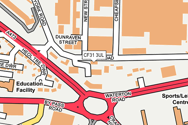
CF31 3UL is located in the Brackla East and Coychurch Lower electoral ward, within the unitary authority of Bridgend and the Welsh Parliamentary constituency of Bridgend. The Local Health Board is Cwm Taf Morgannwg University and the police force is South Wales. This postcode has been in use since January 1980.


GetTheData
Source: OS OpenMap – Local (Ordnance Survey)
Source: OS VectorMap District (Ordnance Survey)
Licence: Open Government Licence (requires attribution)
| Easting | 291791 |
| Northing | 178657 |
| Latitude | 51.496464 |
| Longitude | -3.560190 |
GetTheData
Source: Open Postcode Geo
Licence: Open Government Licence
| Country | Wales |
| Postcode District | CF31 |
➜ See where CF31 is on a map ➜ Where is Bridgend? | |
GetTheData
Source: Land Registry Price Paid Data
Licence: Open Government Licence
Elevation or altitude of CF31 3UL as distance above sea level:
| Metres | Feet | |
|---|---|---|
| Elevation | 10m | 33ft |
Elevation is measured from the approximate centre of the postcode, to the nearest point on an OS contour line from OS Terrain 50, which has contour spacing of ten vertical metres.
➜ How high above sea level am I? Find the elevation of your current position using your device's GPS.
GetTheData
Source: Open Postcode Elevation
Licence: Open Government Licence
| Ward | Brackla East And Coychurch Lower |
| Constituency | Bridgend |
GetTheData
Source: ONS Postcode Database
Licence: Open Government Licence
| Elac Industrial Estate (York Road) | Hernston | 197m |
| Waterton (A48) | Hernston | 263m |
| Elac Industrial Estate (Kingsway) | Tremains | 344m |
| Sony Gate (Kingsway) | Tremains | 391m |
| Tesco (Heol Tre Dwr) | Hernston | 439m |
| Bridgend Station | 1.6km |
| Wildmill Station | 3km |
| Sarn Station | 5.1km |
GetTheData
Source: NaPTAN
Licence: Open Government Licence
GetTheData
Source: ONS Postcode Database
Licence: Open Government Licence


➜ Get more ratings from the Food Standards Agency
GetTheData
Source: Food Standards Agency
Licence: FSA terms & conditions
| Last Collection | |||
|---|---|---|---|
| Location | Mon-Fri | Sat | Distance |
| Ewenny Roundabout | 17:30 | 12:00 | 1,157m |
| Brackla | 17:30 | 12:00 | 1,193m |
| Waunscil Avenue | 17:30 | 12:00 | 1,207m |
GetTheData
Source: Dracos
Licence: Creative Commons Attribution-ShareAlike
The below table lists the International Territorial Level (ITL) codes (formerly Nomenclature of Territorial Units for Statistics (NUTS) codes) and Local Administrative Units (LAU) codes for CF31 3UL:
| ITL 1 Code | Name |
|---|---|
| TLL | Wales |
| ITL 2 Code | Name |
| TLL1 | West Wales and The Valleys |
| ITL 3 Code | Name |
| TLL17 | Bridgend and Neath Port Talbot |
| LAU 1 Code | Name |
| W06000013 | Bridgend |
GetTheData
Source: ONS Postcode Directory
Licence: Open Government Licence
The below table lists the Census Output Area (OA), Lower Layer Super Output Area (LSOA), and Middle Layer Super Output Area (MSOA) for CF31 3UL:
| Code | Name | |
|---|---|---|
| OA | W00005314 | |
| LSOA | W01001003 | Bridgend 015D |
| MSOA | W02000232 | Bridgend 015 |
GetTheData
Source: ONS Postcode Directory
Licence: Open Government Licence
| CF31 3AJ | Heol Tre Dwr | 191m |
| CF31 3UD | New Street | 196m |
| CF31 3BH | Llys Tre Dwr | 278m |
| CF31 3YY | Waterton Road | 322m |
| CF31 3TE | Ogmore Crescent | 589m |
| CF31 3TU | Kent Road | 596m |
| CF31 3SR | Cowbridge Road | 603m |
| CF31 3HJ | Picton Gardens | 678m |
| CF31 3DS | Fairfield Road | 711m |
| CF31 3BD | Cowbridge Road | 717m |
GetTheData
Source: Open Postcode Geo; Land Registry Price Paid Data
Licence: Open Government Licence