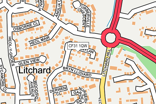
CF31 1QW lies on Penylan in Bridgend. CF31 1QW is located in the Coity Higher electoral ward, within the unitary authority of Bridgend and the Welsh Parliamentary constituency of Bridgend. The Local Health Board is Cwm Taf Morgannwg University and the police force is South Wales. This postcode has been in use since January 1980.


GetTheData
Source: OS OpenMap – Local (Ordnance Survey)
Source: OS VectorMap District (Ordnance Survey)
Licence: Open Government Licence (requires attribution)
| Easting | 290818 |
| Northing | 181976 |
| Latitude | 51.526109 |
| Longitude | -3.575246 |
GetTheData
Source: Open Postcode Geo
Licence: Open Government Licence
| Street | Penylan |
| Town/City | Bridgend |
| Country | Wales |
| Postcode District | CF31 |
➜ See where CF31 is on a map ➜ Where is Bridgend? | |
GetTheData
Source: Land Registry Price Paid Data
Licence: Open Government Licence
Elevation or altitude of CF31 1QW as distance above sea level:
| Metres | Feet | |
|---|---|---|
| Elevation | 70m | 230ft |
Elevation is measured from the approximate centre of the postcode, to the nearest point on an OS contour line from OS Terrain 50, which has contour spacing of ten vertical metres.
➜ How high above sea level am I? Find the elevation of your current position using your device's GPS.
GetTheData
Source: Open Postcode Elevation
Licence: Open Government Licence
| Ward | Coity Higher |
| Constituency | Bridgend |
GetTheData
Source: ONS Postcode Database
Licence: Open Government Licence
35, PENYLAN, BRIDGEND, CF31 1QW 2013 15 FEB £130,000 |
30, PENYLAN, BRIDGEND, CF31 1QW 2004 7 JUL £137,995 |
30, PENYLAN, BRIDGEND, CF31 1QW 2002 12 APR £72,632 |
29, PENYLAN, BRIDGEND, CF31 1QW 2002 8 APR £88,500 |
36, PENYLAN, BRIDGEND, CF31 1QW 2002 25 JAN £75,000 |
GetTheData
Source: HM Land Registry Price Paid Data
Licence: Contains HM Land Registry data © Crown copyright and database right 2025. This data is licensed under the Open Government Licence v3.0.
| Litchard Hill | Derwen | 103m |
| Litchard Hill | Derwen | 133m |
| Cae Caddy Roundabout (Litchsrd Hill) | Derwen | 352m |
| Sarn Park Sainsbury (A4061) | Derwen | 490m |
| Sarn Park Sainsbury (A4061) | Derwen | 503m |
| Wildmill Station | 0.7km |
| Sarn Station | 1.7km |
| Bridgend Station | 2.1km |
GetTheData
Source: NaPTAN
Licence: Open Government Licence
| Percentage of properties with Next Generation Access | 100.0% |
| Percentage of properties with Superfast Broadband | 100.0% |
| Percentage of properties with Ultrafast Broadband | 0.0% |
| Percentage of properties with Full Fibre Broadband | 0.0% |
Superfast Broadband is between 30Mbps and 300Mbps
Ultrafast Broadband is > 300Mbps
| Median download speed | 37.5Mbps |
| Average download speed | 29.5Mbps |
| Maximum download speed | 55.00Mbps |
| Median upload speed | 7.0Mbps |
| Average upload speed | 5.6Mbps |
| Maximum upload speed | 11.40Mbps |
| Percentage of properties unable to receive 2Mbps | 0.0% |
| Percentage of properties unable to receive 5Mbps | 0.0% |
| Percentage of properties unable to receive 10Mbps | 0.0% |
| Percentage of properties unable to receive 30Mbps | 0.0% |
GetTheData
Source: Ofcom
Licence: Ofcom Terms of Use (requires attribution)
Estimated total energy consumption in CF31 1QW by fuel type, 2015.
| Consumption (kWh) | 547,226 |
|---|---|
| Meter count | 38 |
| Mean (kWh/meter) | 14,401 |
| Median (kWh/meter) | 14,415 |
| Consumption (kWh) | 115,239 |
|---|---|
| Meter count | 36 |
| Mean (kWh/meter) | 3,201 |
| Median (kWh/meter) | 2,651 |
GetTheData
Source: Postcode level gas estimates: 2015 (experimental)
Source: Postcode level electricity estimates: 2015 (experimental)
Licence: Open Government Licence
GetTheData
Source: ONS Postcode Database
Licence: Open Government Licence


➜ Get more ratings from the Food Standards Agency
GetTheData
Source: Food Standards Agency
Licence: FSA terms & conditions
| Last Collection | |||
|---|---|---|---|
| Location | Mon-Fri | Sat | Distance |
| Heol Y Groes | 17:30 | 12:00 | 136m |
| Pendre | 17:15 | 12:00 | 898m |
| Coity | 17:00 | 12:00 | 1,471m |
GetTheData
Source: Dracos
Licence: Creative Commons Attribution-ShareAlike
The below table lists the International Territorial Level (ITL) codes (formerly Nomenclature of Territorial Units for Statistics (NUTS) codes) and Local Administrative Units (LAU) codes for CF31 1QW:
| ITL 1 Code | Name |
|---|---|
| TLL | Wales |
| ITL 2 Code | Name |
| TLL1 | West Wales and The Valleys |
| ITL 3 Code | Name |
| TLL17 | Bridgend and Neath Port Talbot |
| LAU 1 Code | Name |
| W06000013 | Bridgend |
GetTheData
Source: ONS Postcode Directory
Licence: Open Government Licence
The below table lists the Census Output Area (OA), Lower Layer Super Output Area (LSOA), and Middle Layer Super Output Area (MSOA) for CF31 1QW:
| Code | Name | |
|---|---|---|
| OA | W00005341 | |
| LSOA | W01001008 | Bridgend 011B |
| MSOA | W02000228 | Bridgend 011 |
GetTheData
Source: ONS Postcode Directory
Licence: Open Government Licence
| CF31 1RB | Litchard Villas | 60m |
| CF31 1QN | Bryn Llidiard | 94m |
| CF31 1QY | Heol Y Groes | 118m |
| CF31 1NH | Nursery Gardens | 137m |
| CF31 1QP | Derwen Close | 142m |
| CF31 1QJ | Litchard Hill | 142m |
| CF31 1YL | Heol Mair | 152m |
| CF31 1QT | Turberville Crescent | 153m |
| CF31 1QQ | Litchard Hill | 156m |
| CF35 6HA | Litchard Hill | 159m |
GetTheData
Source: Open Postcode Geo; Land Registry Price Paid Data
Licence: Open Government Licence