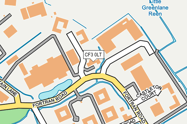
CF3 0LT lies on Fortran Road in St Mellons, Cardiff. CF3 0LT is located in the Trowbridge electoral ward, within the unitary authority of Cardiff and the Welsh Parliamentary constituency of Cardiff South and Penarth. The Local Health Board is Cardiff and Vale University and the police force is South Wales. This postcode has been in use since August 1992.


GetTheData
Source: OS OpenMap – Local (Ordnance Survey)
Source: OS VectorMap District (Ordnance Survey)
Licence: Open Government Licence (requires attribution)
| Easting | 325129 |
| Northing | 181657 |
| Latitude | 51.528840 |
| Longitude | -3.080700 |
GetTheData
Source: Open Postcode Geo
Licence: Open Government Licence
| Street | Fortran Road |
| Locality | St Mellons |
| Town/City | Cardiff |
| Country | Wales |
| Postcode District | CF3 |
➜ See where CF3 is on a map ➜ Where is Cardiff? | |
GetTheData
Source: Land Registry Price Paid Data
Licence: Open Government Licence
Elevation or altitude of CF3 0LT as distance above sea level:
| Metres | Feet | |
|---|---|---|
| Elevation | 10m | 33ft |
Elevation is measured from the approximate centre of the postcode, to the nearest point on an OS contour line from OS Terrain 50, which has contour spacing of ten vertical metres.
➜ How high above sea level am I? Find the elevation of your current position using your device's GPS.
GetTheData
Source: Open Postcode Elevation
Licence: Open Government Licence
| Ward | Trowbridge |
| Constituency | Cardiff South And Penarth |
GetTheData
Source: ONS Postcode Database
Licence: Open Government Licence
| Business Park (Fortran Road) | St Mellons | 282m |
| Business Park (Fortran Road) | St Mellons | 291m |
| Fountain Lane | St Mellons | 426m |
| Fountain Lane | St Mellons | 431m |
| Cypress Drive | St Mellons | 533m |
GetTheData
Source: NaPTAN
Licence: Open Government Licence
Estimated total energy consumption in CF3 0LT by fuel type, 2015.
| Consumption (kWh) | 292,118 |
|---|---|
| Meter count | 13 |
| Mean (kWh/meter) | 22,471 |
| Median (kWh/meter) | 23,596 |
GetTheData
Source: Postcode level gas estimates: 2015 (experimental)
Source: Postcode level electricity estimates: 2015 (experimental)
Licence: Open Government Licence
GetTheData
Source: ONS Postcode Database
Licence: Open Government Licence


➜ Get more ratings from the Food Standards Agency
GetTheData
Source: Food Standards Agency
Licence: FSA terms & conditions
| Last Collection | |||
|---|---|---|---|
| Location | Mon-Fri | Sat | Distance |
| Willowbrook Drive | 17:00 | 11:15 | 976m |
| Ball Road | 17:15 | 11:00 | 3,493m |
| Caeglas Road Post Office | 17:00 | 11:00 | 3,765m |
GetTheData
Source: Dracos
Licence: Creative Commons Attribution-ShareAlike
The below table lists the International Territorial Level (ITL) codes (formerly Nomenclature of Territorial Units for Statistics (NUTS) codes) and Local Administrative Units (LAU) codes for CF3 0LT:
| ITL 1 Code | Name |
|---|---|
| TLL | Wales |
| ITL 2 Code | Name |
| TLL2 | East Wales |
| ITL 3 Code | Name |
| TLL22 | Cardiff and Vale of Glamorgan |
| LAU 1 Code | Name |
| W06000015 | Cardiff |
GetTheData
Source: ONS Postcode Directory
Licence: Open Government Licence
The below table lists the Census Output Area (OA), Lower Layer Super Output Area (LSOA), and Middle Layer Super Output Area (MSOA) for CF3 0LT:
| Code | Name | |
|---|---|---|
| OA | W00009688 | |
| LSOA | W01001882 | Cardiff 011C |
| MSOA | W02000377 | Cardiff 011 |
GetTheData
Source: ONS Postcode Directory
Licence: Open Government Licence
| CF3 0EY | St Mellons Business Park | 212m |
| CF3 0AS | Glenrise Close | 621m |
| CF3 0EW | Maes Y Crochan | 628m |
| CF3 2NN | Mallards Reach | 659m |
| CF3 0EL | Maes Y Crochan | 665m |
| CF3 2DY | The Meadows | 680m |
| CF3 0LZ | Eugene Close | 683m |
| CF3 0LR | Brython Drive | 686m |
| CF3 2PR | Mallards Reach | 686m |
| CF3 0NL | Chervil Close | 706m |
GetTheData
Source: Open Postcode Geo; Land Registry Price Paid Data
Licence: Open Government Licence