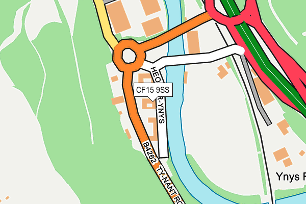
CF15 9SS lies on Ynys Bridge Court in Gwaelod Y Garth, Cardiff. CF15 9SS is located in the Pentyrch and St Fagans electoral ward, within the unitary authority of Cardiff and the Welsh Parliamentary constituency of Cardiff West. The Local Health Board is Cardiff and Vale University and the police force is South Wales. This postcode has been in use since June 1999.


GetTheData
Source: OS OpenMap – Local (Ordnance Survey)
Source: OS VectorMap District (Ordnance Survey)
Licence: Open Government Licence (requires attribution)
| Easting | 312629 |
| Northing | 182492 |
| Latitude | 51.534548 |
| Longitude | -3.261059 |
GetTheData
Source: Open Postcode Geo
Licence: Open Government Licence
| Street | Ynys Bridge Court |
| Locality | Gwaelod Y Garth |
| Town/City | Cardiff |
| Country | Wales |
| Postcode District | CF15 |
➜ See where CF15 is on a map ➜ Where is Gwaelod-y-garth? | |
GetTheData
Source: Land Registry Price Paid Data
Licence: Open Government Licence
Elevation or altitude of CF15 9SS as distance above sea level:
| Metres | Feet | |
|---|---|---|
| Elevation | 30m | 98ft |
Elevation is measured from the approximate centre of the postcode, to the nearest point on an OS contour line from OS Terrain 50, which has contour spacing of ten vertical metres.
➜ How high above sea level am I? Find the elevation of your current position using your device's GPS.
GetTheData
Source: Open Postcode Elevation
Licence: Open Government Licence
| Ward | Pentyrch And St Fagans |
| Constituency | Cardiff West |
GetTheData
Source: ONS Postcode Database
Licence: Open Government Licence
| Ynys Bridge West (Tynant Road) | Morganstown | 63m |
| Ynys Bridge West (Tynant Road) | Morganstown | 79m |
| Ynys Bridge (A4054) | Tongwynlais | 245m |
| Ynys Bridge East (A4054) | Tongwynlais | 293m |
| Ynys Bridge (Cardiff Road) | Tongwynlais | 329m |
| Taffs Well Station | 0.7km |
| Radyr Station | 2.2km |
| Coryton Station | 2.6km |
GetTheData
Source: NaPTAN
Licence: Open Government Licence
GetTheData
Source: ONS Postcode Database
Licence: Open Government Licence


➜ Get more ratings from the Food Standards Agency
GetTheData
Source: Food Standards Agency
Licence: FSA terms & conditions
| Last Collection | |||
|---|---|---|---|
| Location | Mon-Fri | Sat | Distance |
| Tongwynlais Post Office | 17:15 | 12:00 | 741m |
| Taffs Well Post Office | 17:00 | 12:00 | 1,048m |
| Capel Gwyliam | 16:45 | 12:00 | 2,113m |
GetTheData
Source: Dracos
Licence: Creative Commons Attribution-ShareAlike
The below table lists the International Territorial Level (ITL) codes (formerly Nomenclature of Territorial Units for Statistics (NUTS) codes) and Local Administrative Units (LAU) codes for CF15 9SS:
| ITL 1 Code | Name |
|---|---|
| TLL | Wales |
| ITL 2 Code | Name |
| TLL2 | East Wales |
| ITL 3 Code | Name |
| TLL22 | Cardiff and Vale of Glamorgan |
| LAU 1 Code | Name |
| W06000015 | Cardiff |
GetTheData
Source: ONS Postcode Directory
Licence: Open Government Licence
The below table lists the Census Output Area (OA), Lower Layer Super Output Area (LSOA), and Middle Layer Super Output Area (MSOA) for CF15 9SS:
| Code | Name | |
|---|---|---|
| OA | W00009376 | |
| LSOA | W01001820 | Cardiff 006A |
| MSOA | W02000372 | Cardiff 006 |
GetTheData
Source: ONS Postcode Directory
Licence: Open Government Licence
| CF15 7NT | 219m | |
| CF15 9JN | Viaduct Road | 336m |
| CF15 7LL | Birch Hill | 539m |
| CF15 7LN | Wyndham Street | 611m |
| CF15 7LJ | Bute Street | 613m |
| CF15 7NN | Queen Street | 620m |
| CF15 7LH | Merthyr Road | 635m |
| CF15 8LF | Garth Close | 644m |
| CF15 8LD | Gelynis Terrace North | 644m |
| CF15 7LP | Wellington Street | 644m |
GetTheData
Source: Open Postcode Geo; Land Registry Price Paid Data
Licence: Open Government Licence