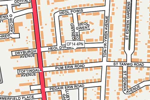
CF14 4PN lies on Heol Dyfed in Cardiff. CF14 4PN is located in the Heath electoral ward, within the unitary authority of Cardiff and the Welsh Parliamentary constituency of Cardiff North. The Local Health Board is Cardiff and Vale University and the police force is South Wales. This postcode has been in use since June 1999.


GetTheData
Source: OS OpenMap – Local (Ordnance Survey)
Source: OS VectorMap District (Ordnance Survey)
Licence: Open Government Licence (requires attribution)
| Easting | 316939 |
| Northing | 180326 |
| Latitude | 51.515727 |
| Longitude | -3.198414 |
GetTheData
Source: Open Postcode Geo
Licence: Open Government Licence
| Street | Heol Dyfed |
| Town/City | Cardiff |
| Country | Wales |
| Postcode District | CF14 |
➜ See where CF14 is on a map ➜ Where is Cardiff? | |
GetTheData
Source: Land Registry Price Paid Data
Licence: Open Government Licence
Elevation or altitude of CF14 4PN as distance above sea level:
| Metres | Feet | |
|---|---|---|
| Elevation | 40m | 131ft |
Elevation is measured from the approximate centre of the postcode, to the nearest point on an OS contour line from OS Terrain 50, which has contour spacing of ten vertical metres.
➜ How high above sea level am I? Find the elevation of your current position using your device's GPS.
GetTheData
Source: Open Postcode Elevation
Licence: Open Government Licence
| Ward | Heath |
| Constituency | Cardiff North |
GetTheData
Source: ONS Postcode Database
Licence: Open Government Licence
9A, HEOL DYFED, CARDIFF, CF14 4PN 2015 30 APR £235,000 |
28, HEOL DYFED, CARDIFF, CF14 4PN 2007 27 APR £175,000 |
28, HEOL DYFED, CARDIFF, CF14 4PN 2004 20 MAY £154,000 |
GetTheData
Source: HM Land Registry Price Paid Data
Licence: Contains HM Land Registry data © Crown copyright and database right 2025. This data is licensed under the Open Government Licence v3.0.
| Heol Dyfed (Caerphilly Road) | Birchgrove | 146m |
| Pheonix Estate (Caerphilly Road) | Birchgrove | 174m |
| Summerfield Place (Caerphilly Road) | Birchgrove | 217m |
| Pedair Erw Road (Caerphilly Road) | Birchgrove | 256m |
| Phoenix Estate (Caerphilly Road) | Birchgrove | 278m |
| Ty Glas Station | 0.7km |
| Birchgrove Station | 0.7km |
| Heath Low Level Station | 1.1km |
GetTheData
Source: NaPTAN
Licence: Open Government Licence
| Percentage of properties with Next Generation Access | 100.0% |
| Percentage of properties with Superfast Broadband | 100.0% |
| Percentage of properties with Ultrafast Broadband | 100.0% |
| Percentage of properties with Full Fibre Broadband | 100.0% |
Superfast Broadband is between 30Mbps and 300Mbps
Ultrafast Broadband is > 300Mbps
| Median download speed | 100.0Mbps |
| Average download speed | 96.5Mbps |
| Maximum download speed | 200.00Mbps |
| Median upload speed | 4.8Mbps |
| Average upload speed | 8.7Mbps |
| Maximum upload speed | 20.00Mbps |
| Percentage of properties unable to receive 2Mbps | 0.0% |
| Percentage of properties unable to receive 5Mbps | 0.0% |
| Percentage of properties unable to receive 10Mbps | 0.0% |
| Percentage of properties unable to receive 30Mbps | 0.0% |
GetTheData
Source: Ofcom
Licence: Ofcom Terms of Use (requires attribution)
Estimated total energy consumption in CF14 4PN by fuel type, 2015.
| Consumption (kWh) | 398,717 |
|---|---|
| Meter count | 36 |
| Mean (kWh/meter) | 11,075 |
| Median (kWh/meter) | 10,662 |
| Consumption (kWh) | 135,467 |
|---|---|
| Meter count | 34 |
| Mean (kWh/meter) | 3,984 |
| Median (kWh/meter) | 3,590 |
GetTheData
Source: Postcode level gas estimates: 2015 (experimental)
Source: Postcode level electricity estimates: 2015 (experimental)
Licence: Open Government Licence
GetTheData
Source: ONS Postcode Database
Licence: Open Government Licence


➜ Get more ratings from the Food Standards Agency
GetTheData
Source: Food Standards Agency
Licence: FSA terms & conditions
| Last Collection | |||
|---|---|---|---|
| Location | Mon-Fri | Sat | Distance |
| St Cadoc Road | 17:30 | 12:00 | 354m |
| St Isan Road Post Office | 17:30 | 12:00 | 611m |
| Heathwood Road East | 17:30 | 12:00 | 845m |
GetTheData
Source: Dracos
Licence: Creative Commons Attribution-ShareAlike
The below table lists the International Territorial Level (ITL) codes (formerly Nomenclature of Territorial Units for Statistics (NUTS) codes) and Local Administrative Units (LAU) codes for CF14 4PN:
| ITL 1 Code | Name |
|---|---|
| TLL | Wales |
| ITL 2 Code | Name |
| TLL2 | East Wales |
| ITL 3 Code | Name |
| TLL22 | Cardiff and Vale of Glamorgan |
| LAU 1 Code | Name |
| W06000015 | Cardiff |
GetTheData
Source: ONS Postcode Directory
Licence: Open Government Licence
The below table lists the Census Output Area (OA), Lower Layer Super Output Area (LSOA), and Middle Layer Super Output Area (MSOA) for CF14 4PN:
| Code | Name | |
|---|---|---|
| OA | W00010162 | |
| LSOA | W01001773 | Cardiff 012A |
| MSOA | W02000378 | Cardiff 012 |
GetTheData
Source: ONS Postcode Directory
Licence: Open Government Licence
| CF14 4PE | Pum Erw Road | 50m |
| CF14 4PF | Pum Erw Road | 81m |
| CF14 4PJ | Heol Gwynedd | 82m |
| CF14 4PL | Heol Gwent | 95m |
| CF14 4PG | Heol Powis | 124m |
| CF14 4NU | Pedair Erw Road | 131m |
| CF14 4NR | Caerphilly Road | 137m |
| CF14 4PB | Ton Yr Ywen Avenue | 153m |
| CF14 4NZ | Ton Yr Ywen Avenue | 173m |
| CF14 4QE | Caerphilly Road | 179m |
GetTheData
Source: Open Postcode Geo; Land Registry Price Paid Data
Licence: Open Government Licence