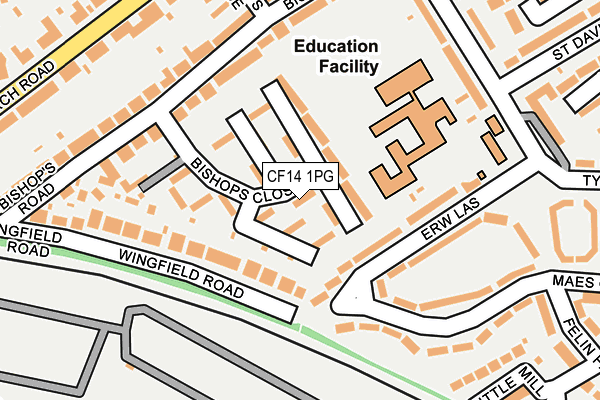
CF14 1PG lies on Bishops Close in Whitchurch, Cardiff. CF14 1PG is located in the Whitchurch and Tongwynlais electoral ward, within the unitary authority of Cardiff and the Welsh Parliamentary constituency of Cardiff North. The Local Health Board is Cardiff and Vale University and the police force is South Wales. This postcode has been in use since June 1999.


GetTheData
Source: OS OpenMap – Local (Ordnance Survey)
Source: OS VectorMap District (Ordnance Survey)
Licence: Open Government Licence (requires attribution)
| Easting | 315244 |
| Northing | 179597 |
| Latitude | 51.508923 |
| Longitude | -3.222669 |
GetTheData
Source: Open Postcode Geo
Licence: Open Government Licence
| Street | Bishops Close |
| Locality | Whitchurch |
| Town/City | Cardiff |
| Country | Wales |
| Postcode District | CF14 |
➜ See where CF14 is on a map ➜ Where is Cardiff? | |
GetTheData
Source: Land Registry Price Paid Data
Licence: Open Government Licence
Elevation or altitude of CF14 1PG as distance above sea level:
| Metres | Feet | |
|---|---|---|
| Elevation | 30m | 98ft |
Elevation is measured from the approximate centre of the postcode, to the nearest point on an OS contour line from OS Terrain 50, which has contour spacing of ten vertical metres.
➜ How high above sea level am I? Find the elevation of your current position using your device's GPS.
GetTheData
Source: Open Postcode Elevation
Licence: Open Government Licence
| Ward | Whitchurch And Tongwynlais |
| Constituency | Cardiff North |
GetTheData
Source: ONS Postcode Database
Licence: Open Government Licence
| Bishops Rd (Tynewydd) | Whitchurch | 252m |
| Bishops Place (Church Road) | Whitchurch | 258m |
| Clas Tynewdd (Tynewdd) | Whitchurch | 270m |
| Wingfield Rd (Station Road) | Whitchurch | 352m |
| Clyro Place (Hawthorn Road East) | Llandaff North | 354m |
| Llandaf Station | 0.4km |
| Danescourt Station | 1.2km |
| Whitchurch (Cardiff) Station | 1.3km |
GetTheData
Source: NaPTAN
Licence: Open Government Licence
| Percentage of properties with Next Generation Access | 100.0% |
| Percentage of properties with Superfast Broadband | 100.0% |
| Percentage of properties with Ultrafast Broadband | 100.0% |
| Percentage of properties with Full Fibre Broadband | 0.0% |
Superfast Broadband is between 30Mbps and 300Mbps
Ultrafast Broadband is > 300Mbps
| Percentage of properties unable to receive 2Mbps | 0.0% |
| Percentage of properties unable to receive 5Mbps | 0.0% |
| Percentage of properties unable to receive 10Mbps | 0.0% |
| Percentage of properties unable to receive 30Mbps | 0.0% |
GetTheData
Source: Ofcom
Licence: Ofcom Terms of Use (requires attribution)
GetTheData
Source: ONS Postcode Database
Licence: Open Government Licence


➜ Get more ratings from the Food Standards Agency
GetTheData
Source: Food Standards Agency
Licence: FSA terms & conditions
| Last Collection | |||
|---|---|---|---|
| Location | Mon-Fri | Sat | Distance |
| Church Road East | 17:30 | 12:00 | 263m |
| Llandaff North Post Office | 17:30 | 12:00 | 408m |
| College Road | 17:45 | 12:00 | 577m |
GetTheData
Source: Dracos
Licence: Creative Commons Attribution-ShareAlike
The below table lists the International Territorial Level (ITL) codes (formerly Nomenclature of Territorial Units for Statistics (NUTS) codes) and Local Administrative Units (LAU) codes for CF14 1PG:
| ITL 1 Code | Name |
|---|---|
| TLL | Wales |
| ITL 2 Code | Name |
| TLL2 | East Wales |
| ITL 3 Code | Name |
| TLL22 | Cardiff and Vale of Glamorgan |
| LAU 1 Code | Name |
| W06000015 | Cardiff |
GetTheData
Source: ONS Postcode Directory
Licence: Open Government Licence
The below table lists the Census Output Area (OA), Lower Layer Super Output Area (LSOA), and Middle Layer Super Output Area (MSOA) for CF14 1PG:
| Code | Name | |
|---|---|---|
| OA | W00009726 | |
| LSOA | W01001887 | Cardiff 020A |
| MSOA | W02000386 | Cardiff 020 |
GetTheData
Source: ONS Postcode Directory
Licence: Open Government Licence
| CF14 1PL | Bishops Close | 29m |
| CF14 1PA | Bishops Close | 31m |
| CF14 1PH | Bishops Close | 35m |
| CF14 1PF | Bishops Close | 44m |
| CF14 1PB | Bishops Close | 49m |
| CF14 1PJ | Bishops Close | 49m |
| CF14 1NH | Bishops Close | 50m |
| CF14 1NB | Bishops Close | 57m |
| CF14 1PE | Bishops Close | 70m |
| CF14 1ND | Bishops Close | 82m |
GetTheData
Source: Open Postcode Geo; Land Registry Price Paid Data
Licence: Open Government Licence