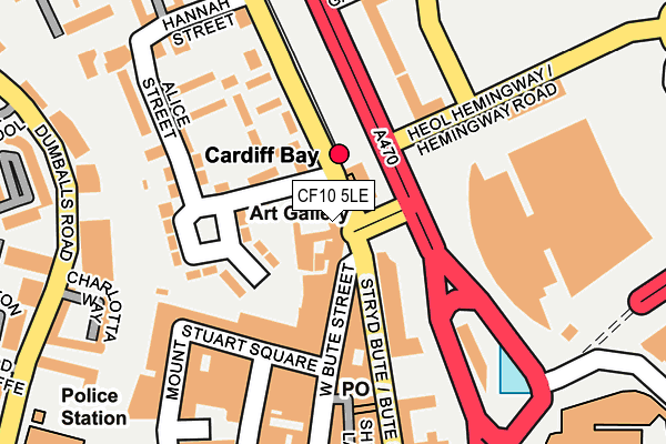
CF10 5LE lies on Bute Street in Cardiff. CF10 5LE is located in the Butetown electoral ward, within the unitary authority of Cardiff and the Welsh Parliamentary constituency of Cardiff South and Penarth. The Local Health Board is Cardiff and Vale University and the police force is South Wales. This postcode has been in use since June 1999.


GetTheData
Source: OS OpenMap – Local (Ordnance Survey)
Source: OS VectorMap District (Ordnance Survey)
Licence: Open Government Licence (requires attribution)
| Easting | 319054 |
| Northing | 174842 |
| Latitude | 51.466736 |
| Longitude | -3.166690 |
GetTheData
Source: Open Postcode Geo
Licence: Open Government Licence
| Street | Bute Street |
| Town/City | Cardiff |
| Country | Wales |
| Postcode District | CF10 |
➜ See where CF10 is on a map ➜ Where is Cardiff? | |
GetTheData
Source: Land Registry Price Paid Data
Licence: Open Government Licence
Elevation or altitude of CF10 5LE as distance above sea level:
| Metres | Feet | |
|---|---|---|
| Elevation | 10m | 33ft |
Elevation is measured from the approximate centre of the postcode, to the nearest point on an OS contour line from OS Terrain 50, which has contour spacing of ten vertical metres.
➜ How high above sea level am I? Find the elevation of your current position using your device's GPS.
GetTheData
Source: Open Postcode Elevation
Licence: Open Government Licence
| Ward | Butetown |
| Constituency | Cardiff South And Penarth |
GetTheData
Source: ONS Postcode Database
Licence: Open Government Licence
130 - 132, BUTE STREET, CARDIFF, CF10 5LE 2007 21 SEP £825,000 |
GetTheData
Source: HM Land Registry Price Paid Data
Licence: Contains HM Land Registry data © Crown copyright and database right 2024. This data is licensed under the Open Government Licence v3.0.
| Cardiff Bay Station (Bute Street) | Butetown | 49m |
| Cardiff Bay Station (Bute Street) | Butetown | 85m |
| Lloyd George Avenue | Atlantic Wharf | 89m |
| The Flourish (Collingdon Road) | Butetown | 109m |
| Nat West Building (Bute Street) | Butetown | 135m |
| Cardiff Bay Station | 0km |
| Cardiff Central Station | 1.4km |
| Grangetown (Cardiff) Station | 1.6km |
GetTheData
Source: NaPTAN
Licence: Open Government Licence
Estimated total energy consumption in CF10 5LE by fuel type, 2015.
| Consumption (kWh) | 130,423 |
|---|---|
| Meter count | 41 |
| Mean (kWh/meter) | 3,181 |
| Median (kWh/meter) | 2,825 |
GetTheData
Source: Postcode level gas estimates: 2015 (experimental)
Source: Postcode level electricity estimates: 2015 (experimental)
Licence: Open Government Licence
GetTheData
Source: ONS Postcode Database
Licence: Open Government Licence


➜ Get more ratings from the Food Standards Agency
GetTheData
Source: Food Standards Agency
Licence: FSA terms & conditions
| Last Collection | |||
|---|---|---|---|
| Location | Mon-Fri | Sat | Distance |
| West Bute Street | 18:30 | 11:30 | 56m |
| Mount Stuart Square | 18:30 | 11:30 | 130m |
| Bute Street Post Office | 18:30 | 12:00 | 175m |
GetTheData
Source: Dracos
Licence: Creative Commons Attribution-ShareAlike
The below table lists the International Territorial Level (ITL) codes (formerly Nomenclature of Territorial Units for Statistics (NUTS) codes) and Local Administrative Units (LAU) codes for CF10 5LE:
| ITL 1 Code | Name |
|---|---|
| TLL | Wales |
| ITL 2 Code | Name |
| TLL2 | East Wales |
| ITL 3 Code | Name |
| TLL22 | Cardiff and Vale of Glamorgan |
| LAU 1 Code | Name |
| W06000015 | Cardiff |
GetTheData
Source: ONS Postcode Directory
Licence: Open Government Licence
The below table lists the Census Output Area (OA), Lower Layer Super Output Area (LSOA), and Middle Layer Super Output Area (MSOA) for CF10 5LE:
| Code | Name | |
|---|---|---|
| OA | W00010216 | |
| LSOA | W01001699 | Cardiff 049A |
| MSOA | W02000423 | Cardiff 049 |
GetTheData
Source: ONS Postcode Directory
Licence: Open Government Licence
| CF10 5EA | Bute Street | 30m |
| CF10 5LH | West Bute Street | 40m |
| CF10 5AE | Bute Street | 76m |
| CF10 5LD | West Close | 86m |
| CF10 5LL | West Bute Street | 91m |
| CF10 5FL | Mount Stuart Square | 108m |
| CF10 5LR | Mount Stuart Square | 116m |
| CF10 5LJ | West Bute Street | 116m |
| CF10 5AP | Belmont Walk | 126m |
| CF10 4DD | Ffordd Garthorne | 134m |
GetTheData
Source: Open Postcode Geo; Land Registry Price Paid Data
Licence: Open Government Licence