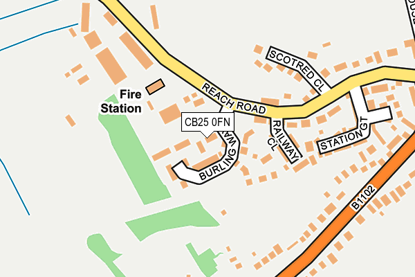
CB25 0FN is located in the Burwell electoral ward, within the local authority district of East Cambridgeshire and the English Parliamentary constituency of South East Cambridgeshire. The Sub Integrated Care Board (ICB) Location is NHS Cambridgeshire and Peterborough ICB - 06H and the police force is Cambridgeshire. This postcode has been in use since May 2017.


GetTheData
Source: OS OpenMap – Local (Ordnance Survey)
Source: OS VectorMap District (Ordnance Survey)
Licence: Open Government Licence (requires attribution)
| Easting | 558586 |
| Northing | 265710 |
| Latitude | 52.266700 |
| Longitude | 0.322580 |
GetTheData
Source: Open Postcode Geo
Licence: Open Government Licence
| Country | England |
| Postcode District | CB25 |
➜ See where CB25 is on a map ➜ Where is Burwell? | |
GetTheData
Source: Land Registry Price Paid Data
Licence: Open Government Licence
| Ward | Burwell |
| Constituency | South East Cambridgeshire |
GetTheData
Source: ONS Postcode Database
Licence: Open Government Licence
| Swaffham Road | Burwell | 237m |
| Swaffham Road | Burwell | 246m |
| Mandeville (High Street) | Burwell | 406m |
| Mandeville (High Street) | Burwell | 439m |
| St Mary's Church (High Street) | Burwell | 547m |
GetTheData
Source: NaPTAN
Licence: Open Government Licence
| Percentage of properties with Next Generation Access | 100.0% |
| Percentage of properties with Superfast Broadband | 100.0% |
| Percentage of properties with Ultrafast Broadband | 0.0% |
| Percentage of properties with Full Fibre Broadband | 0.0% |
Superfast Broadband is between 30Mbps and 300Mbps
Ultrafast Broadband is > 300Mbps
| Percentage of properties unable to receive 2Mbps | 0.0% |
| Percentage of properties unable to receive 5Mbps | 0.0% |
| Percentage of properties unable to receive 10Mbps | 0.0% |
| Percentage of properties unable to receive 30Mbps | 0.0% |
GetTheData
Source: Ofcom
Licence: Ofcom Terms of Use (requires attribution)
GetTheData
Source: ONS Postcode Database
Licence: Open Government Licence


➜ Get more ratings from the Food Standards Agency
GetTheData
Source: Food Standards Agency
Licence: FSA terms & conditions
| Last Collection | |||
|---|---|---|---|
| Location | Mon-Fri | Sat | Distance |
| Swaffham Road | 17:00 | 10:30 | 445m |
| High Street | 17:00 | 10:00 | 706m |
| Burwell Post Office | 17:00 | 10:15 | 1,012m |
GetTheData
Source: Dracos
Licence: Creative Commons Attribution-ShareAlike
The below table lists the International Territorial Level (ITL) codes (formerly Nomenclature of Territorial Units for Statistics (NUTS) codes) and Local Administrative Units (LAU) codes for CB25 0FN:
| ITL 1 Code | Name |
|---|---|
| TLH | East |
| ITL 2 Code | Name |
| TLH1 | East Anglia |
| ITL 3 Code | Name |
| TLH12 | Cambridgeshire CC |
| LAU 1 Code | Name |
| E07000009 | East Cambridgeshire |
GetTheData
Source: ONS Postcode Directory
Licence: Open Government Licence
The below table lists the Census Output Area (OA), Lower Layer Super Output Area (LSOA), and Middle Layer Super Output Area (MSOA) for CB25 0FN:
| Code | Name | |
|---|---|---|
| OA | E00090870 | |
| LSOA | E01018013 | East Cambridgeshire 008A |
| MSOA | E02003739 | East Cambridgeshire 008 |
GetTheData
Source: ONS Postcode Directory
Licence: Open Government Licence
| CB25 0AH | Reach Road | 97m |
| CB25 0DW | Railway Close | 110m |
| CB25 0AL | Scotred Close | 148m |
| CB25 0BU | Reach Road | 182m |
| CB25 0AN | Swaffham Road | 192m |
| CB25 0BZ | Station Gate | 219m |
| CB25 0AR | Tan House Lane | 389m |
| CB25 0AG | Mandeville | 456m |
| CB25 0AQ | Church Lane | 482m |
| CB25 0HB | High Street | 525m |
GetTheData
Source: Open Postcode Geo; Land Registry Price Paid Data
Licence: Open Government Licence