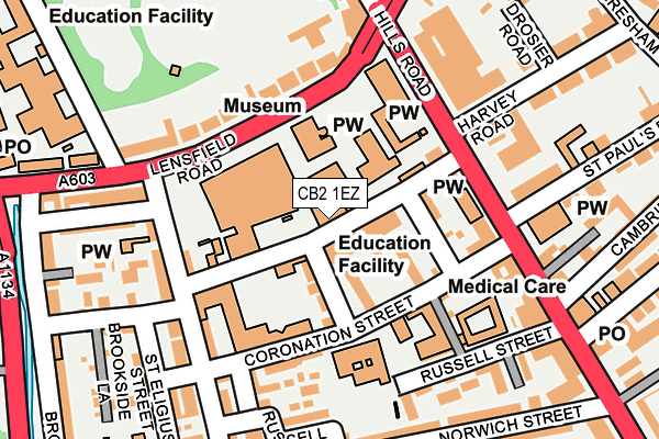
CB2 1EZ is located in the Market electoral ward, within the local authority district of Cambridge and the English Parliamentary constituency of Cambridge. The Sub Integrated Care Board (ICB) Location is NHS Cambridgeshire and Peterborough ICB - 06H and the police force is Cambridgeshire. This postcode has been in use since August 1992.


GetTheData
Source: OS OpenMap – Local (Ordnance Survey)
Source: OS VectorMap District (Ordnance Survey)
Licence: Open Government Licence (requires attribution)
| Easting | 545438 |
| Northing | 257623 |
| Latitude | 52.197662 |
| Longitude | 0.126552 |
GetTheData
Source: Open Postcode Geo
Licence: Open Government Licence
| Country | England |
| Postcode District | CB2 |
➜ See where CB2 is on a map ➜ Where is Cambridge? | |
GetTheData
Source: Land Registry Price Paid Data
Licence: Open Government Licence
Elevation or altitude of CB2 1EZ as distance above sea level:
| Metres | Feet | |
|---|---|---|
| Elevation | 10m | 33ft |
Elevation is measured from the approximate centre of the postcode, to the nearest point on an OS contour line from OS Terrain 50, which has contour spacing of ten vertical metres.
➜ How high above sea level am I? Find the elevation of your current position using your device's GPS.
GetTheData
Source: Open Postcode Elevation
Licence: Open Government Licence
| Ward | Market |
| Constituency | Cambridge |
GetTheData
Source: ONS Postcode Database
Licence: Open Government Licence
| Catholic Church (Lensfield Road) | Cambridge | 107m |
| St Paul's Road (Hills Road) | Cambridge | 145m |
| St Paul's Road (Hills Road) | Cambridge | 149m |
| Brookside (Lensfield Road) | Cambridge | 237m |
| Gonville Place | Cambridge | 297m |
| Cambridge Station | 0.8km |
GetTheData
Source: NaPTAN
Licence: Open Government Licence
GetTheData
Source: ONS Postcode Database
Licence: Open Government Licence


➜ Get more ratings from the Food Standards Agency
GetTheData
Source: Food Standards Agency
Licence: FSA terms & conditions
| Last Collection | |||
|---|---|---|---|
| Location | Mon-Fri | Sat | Distance |
| Panton Street | 18:45 | 12:00 | 218m |
| Hills Road Post Office | 19:00 | 12:00 | 276m |
| Leys School | 18:15 | 12:00 | 313m |
GetTheData
Source: Dracos
Licence: Creative Commons Attribution-ShareAlike
The below table lists the International Territorial Level (ITL) codes (formerly Nomenclature of Territorial Units for Statistics (NUTS) codes) and Local Administrative Units (LAU) codes for CB2 1EZ:
| ITL 1 Code | Name |
|---|---|
| TLH | East |
| ITL 2 Code | Name |
| TLH1 | East Anglia |
| ITL 3 Code | Name |
| TLH12 | Cambridgeshire CC |
| LAU 1 Code | Name |
| E07000008 | Cambridge |
GetTheData
Source: ONS Postcode Directory
Licence: Open Government Licence
The below table lists the Census Output Area (OA), Lower Layer Super Output Area (LSOA), and Middle Layer Super Output Area (MSOA) for CB2 1EZ:
| Code | Name | |
|---|---|---|
| OA | E00090806 | |
| LSOA | E01018005 | Cambridge 012D |
| MSOA | E02003730 | Cambridge 012 |
GetTheData
Source: ONS Postcode Directory
Licence: Open Government Licence
| CB2 1HQ | Bentinck Terrace | 50m |
| CB2 1JJ | Princess Court | 70m |
| CB2 1HG | Bentinck Street | 74m |
| CB2 1JH | Hanover Court | 81m |
| CB2 1HE | Union Road | 84m |
| CB2 1HH | George Iv Street | 93m |
| CB2 1HJ | Coronation Street | 116m |
| CB2 1EG | Lensfield Road | 126m |
| CB2 1HP | Panton Street | 161m |
| CB2 1HZ | Coronation Mews | 161m |
GetTheData
Source: Open Postcode Geo; Land Registry Price Paid Data
Licence: Open Government Licence