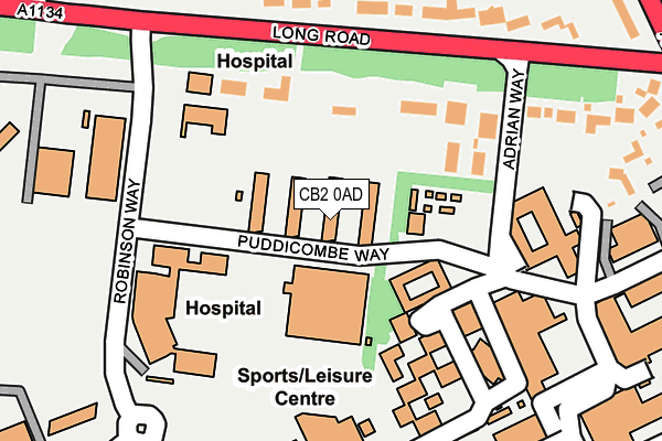
CB2 0AD is located in the Queen Edith's electoral ward, within the local authority district of Cambridge and the English Parliamentary constituency of South Cambridgeshire. The Sub Integrated Care Board (ICB) Location is NHS Cambridgeshire and Peterborough ICB - 06H and the police force is Cambridgeshire. This postcode has been in use since July 2010.


GetTheData
Source: OS OpenMap – Local (Ordnance Survey)
Source: OS VectorMap District (Ordnance Survey)
Licence: Open Government Licence (requires attribution)
| Easting | 546282 |
| Northing | 255410 |
| Latitude | 52.177557 |
| Longitude | 0.137937 |
GetTheData
Source: Open Postcode Geo
Licence: Open Government Licence
| Country | England |
| Postcode District | CB2 |
➜ See where CB2 is on a map ➜ Where is Cambridge? | |
GetTheData
Source: Land Registry Price Paid Data
Licence: Open Government Licence
Elevation or altitude of CB2 0AD as distance above sea level:
| Metres | Feet | |
|---|---|---|
| Elevation | 20m | 66ft |
Elevation is measured from the approximate centre of the postcode, to the nearest point on an OS contour line from OS Terrain 50, which has contour spacing of ten vertical metres.
➜ How high above sea level am I? Find the elevation of your current position using your device's GPS.
GetTheData
Source: Open Postcode Elevation
Licence: Open Government Licence
| Ward | Queen Edith's |
| Constituency | South Cambridgeshire |
GetTheData
Source: ONS Postcode Database
Licence: Open Government Licence
| Puddicombe Way | Addenbrooke's | 142m |
| Robinson Way (Long Road) | Cambridge | 184m |
| Robinson Way (Long Road) | Cambridge | 207m |
| Long Rd 6th Form Coll (Robinson Way) | Cambridge | 208m |
| Long Rd 6th Form Coll (Robinson Way) | Cambridge | 210m |
| Cambridge Station | 1.8km |
| Shelford (Cambs) Station | 3.2km |
GetTheData
Source: NaPTAN
Licence: Open Government Licence
GetTheData
Source: ONS Postcode Database
Licence: Open Government Licence


➜ Get more ratings from the Food Standards Agency
GetTheData
Source: Food Standards Agency
Licence: FSA terms & conditions
| Last Collection | |||
|---|---|---|---|
| Location | Mon-Fri | Sat | Distance |
| Addenbrookes Nurses Home | 17:30 | 12:45 | 131m |
| Luard Road | 18:45 | 13:00 | 708m |
| Fendon Road | 18:45 | 12:30 | 735m |
GetTheData
Source: Dracos
Licence: Creative Commons Attribution-ShareAlike
The below table lists the International Territorial Level (ITL) codes (formerly Nomenclature of Territorial Units for Statistics (NUTS) codes) and Local Administrative Units (LAU) codes for CB2 0AD:
| ITL 1 Code | Name |
|---|---|
| TLH | East |
| ITL 2 Code | Name |
| TLH1 | East Anglia |
| ITL 3 Code | Name |
| TLH12 | Cambridgeshire CC |
| LAU 1 Code | Name |
| E07000008 | Cambridge |
GetTheData
Source: ONS Postcode Directory
Licence: Open Government Licence
The below table lists the Census Output Area (OA), Lower Layer Super Output Area (LSOA), and Middle Layer Super Output Area (MSOA) for CB2 0AD:
| Code | Name | |
|---|---|---|
| OA | E00167374 | |
| LSOA | E01017993 | Cambridge 013B |
| MSOA | E02003731 | Cambridge 013 |
GetTheData
Source: ONS Postcode Directory
Licence: Open Government Licence
| CB2 8PS | Long Road | 153m |
| CB2 8BA | Long Road | 166m |
| CB2 8PP | Long Road | 202m |
| CB2 0QG | Hills Road | 336m |
| CB2 8PR | Long Road | 383m |
| CB2 0QS | Hills Road | 419m |
| CB2 8RP | Hills Road | 423m |
| CB2 8QE | Hills Road | 494m |
| CB2 8PN | Sedley Taylor Road | 512m |
| CB1 7RU | Fendon Close | 520m |
GetTheData
Source: Open Postcode Geo; Land Registry Price Paid Data
Licence: Open Government Licence