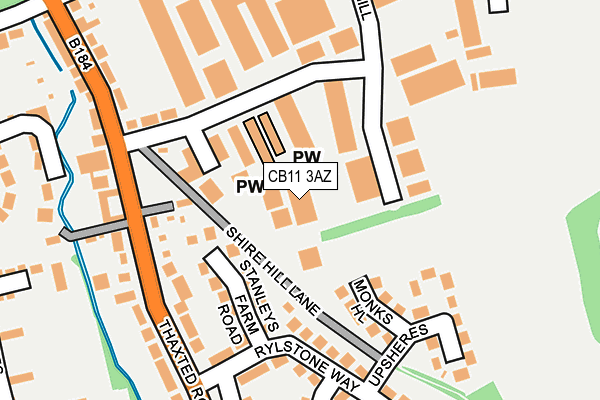
CB11 3AZ is located in the Saffron Walden Shire electoral ward, within the local authority district of Uttlesford and the English Parliamentary constituency of Saffron Walden. The Sub Integrated Care Board (ICB) Location is NHS Hertfordshire and West Essex ICB - 07H and the police force is Essex. This postcode has been in use since February 1990.


GetTheData
Source: OS OpenMap – Local (Ordnance Survey)
Source: OS VectorMap District (Ordnance Survey)
Licence: Open Government Licence (requires attribution)
| Easting | 554764 |
| Northing | 237967 |
| Latitude | 52.018544 |
| Longitude | 0.253969 |
GetTheData
Source: Open Postcode Geo
Licence: Open Government Licence
| Country | England |
| Postcode District | CB11 |
➜ See where CB11 is on a map ➜ Where is Saffron Walden? | |
GetTheData
Source: Land Registry Price Paid Data
Licence: Open Government Licence
Elevation or altitude of CB11 3AZ as distance above sea level:
| Metres | Feet | |
|---|---|---|
| Elevation | 80m | 262ft |
Elevation is measured from the approximate centre of the postcode, to the nearest point on an OS contour line from OS Terrain 50, which has contour spacing of ten vertical metres.
➜ How high above sea level am I? Find the elevation of your current position using your device's GPS.
GetTheData
Source: Open Postcode Elevation
Licence: Open Government Licence
| Ward | Saffron Walden Shire |
| Constituency | Saffron Walden |
GetTheData
Source: ONS Postcode Database
Licence: Open Government Licence
| Peaslands Road (Thaxted Road) | Saffron Walden | 250m |
| Peaslands Road (Thaxted Road) | Saffron Walden | 268m |
| Winstanley Road | Saffron Walden | 446m |
| Winstanley Road | Saffron Walden | 461m |
| South Road (Peaslands Road) | Saffron Walden | 504m |
| Audley End Station | 3.6km |
| Newport (Essex) Station | 5.1km |
| Great Chesterford Station | 6.2km |
GetTheData
Source: NaPTAN
Licence: Open Government Licence
GetTheData
Source: ONS Postcode Database
Licence: Open Government Licence


➜ Get more ratings from the Food Standards Agency
GetTheData
Source: Food Standards Agency
Licence: FSA terms & conditions
| Last Collection | |||
|---|---|---|---|
| Location | Mon-Fri | Sat | Distance |
| Thaxted Road | 17:30 | 12:00 | 186m |
| Peasland Road | 17:30 | 12:00 | 413m |
| Tesco Stores | 17:45 | 11:00 | 502m |
GetTheData
Source: Dracos
Licence: Creative Commons Attribution-ShareAlike
The below table lists the International Territorial Level (ITL) codes (formerly Nomenclature of Territorial Units for Statistics (NUTS) codes) and Local Administrative Units (LAU) codes for CB11 3AZ:
| ITL 1 Code | Name |
|---|---|
| TLH | East |
| ITL 2 Code | Name |
| TLH3 | Essex |
| ITL 3 Code | Name |
| TLH35 | West Essex |
| LAU 1 Code | Name |
| E07000077 | Uttlesford |
GetTheData
Source: ONS Postcode Directory
Licence: Open Government Licence
The below table lists the Census Output Area (OA), Lower Layer Super Output Area (LSOA), and Middle Layer Super Output Area (MSOA) for CB11 3AZ:
| Code | Name | |
|---|---|---|
| OA | E00112209 | |
| LSOA | E01022081 | Uttlesford 002F |
| MSOA | E02004592 | Uttlesford 002 |
GetTheData
Source: ONS Postcode Directory
Licence: Open Government Licence
| CB11 3AU | Shire Hill Industrial Estate | 103m |
| CB11 3BN | Stanleys Farm Road | 118m |
| CB11 3BW | Monks Hill | 129m |
| CB11 3AN | The Shires | 166m |
| CB11 3WA | Shire Hill | 169m |
| CB11 3BL | Rylstone Way | 169m |
| CB11 3BS | Rylstone Way | 182m |
| CB11 3AQ | Shire Hill | 186m |
| CB11 3BP | Upsheres | 199m |
| CB11 3BJ | Thaxted Road | 202m |
GetTheData
Source: Open Postcode Geo; Land Registry Price Paid Data
Licence: Open Government Licence