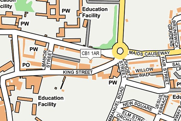
CB1 1AR is located in the Market electoral ward, within the local authority district of Cambridge and the English Parliamentary constituency of Cambridge. The Sub Integrated Care Board (ICB) Location is NHS Cambridgeshire and Peterborough ICB - 06H and the police force is Cambridgeshire. This postcode has been in use since February 2017.


GetTheData
Source: OS OpenMap – Local (Ordnance Survey)
Source: OS VectorMap District (Ordnance Survey)
Licence: Open Government Licence (requires attribution)
| Easting | 545340 |
| Northing | 258730 |
| Latitude | 52.207646 |
| Longitude | 0.125622 |
GetTheData
Source: Open Postcode Geo
Licence: Open Government Licence
| Country | England |
| Postcode District | CB1 |
➜ See where CB1 is on a map ➜ Where is Cambridge? | |
GetTheData
Source: Land Registry Price Paid Data
Licence: Open Government Licence
| Ward | Market |
| Constituency | Cambridge |
GetTheData
Source: ONS Postcode Database
Licence: Open Government Licence
| Belmont Place (Jesus Lane) | Cambridge | 40m |
| Belmont Place (Jesus Lane) | Cambridge | 44m |
| The Busway New Square (Emmanuel Road) | Cambridge | 129m |
| Jesus College (Victoria Avenue) | Cambridge | 133m |
| Jesus College (Victoria Avenue) | Cambridge | 147m |
| Cambridge Station | 1.7km |
GetTheData
Source: NaPTAN
Licence: Open Government Licence
GetTheData
Source: ONS Postcode Database
Licence: Open Government Licence


➜ Get more ratings from the Food Standards Agency
GetTheData
Source: Food Standards Agency
Licence: FSA terms & conditions
| Last Collection | |||
|---|---|---|---|
| Location | Mon-Fri | Sat | Distance |
| King Street | 18:45 | 13:00 | 47m |
| Maids Causeway | 18:30 | 13:00 | 150m |
| Jesus Lane | 18:30 | 12:30 | 176m |
GetTheData
Source: Dracos
Licence: Creative Commons Attribution-ShareAlike
The below table lists the International Territorial Level (ITL) codes (formerly Nomenclature of Territorial Units for Statistics (NUTS) codes) and Local Administrative Units (LAU) codes for CB1 1AR:
| ITL 1 Code | Name |
|---|---|
| TLH | East |
| ITL 2 Code | Name |
| TLH1 | East Anglia |
| ITL 3 Code | Name |
| TLH12 | Cambridgeshire CC |
| LAU 1 Code | Name |
| E07000008 | Cambridge |
GetTheData
Source: ONS Postcode Directory
Licence: Open Government Licence
The below table lists the Census Output Area (OA), Lower Layer Super Output Area (LSOA), and Middle Layer Super Output Area (MSOA) for CB1 1AR:
| Code | Name | |
|---|---|---|
| OA | E00090703 | |
| LSOA | E01032797 | Cambridge 007G |
| MSOA | E02003725 | Cambridge 007 |
GetTheData
Source: ONS Postcode Directory
Licence: Open Government Licence
| CB1 1LD | King Street | 29m |
| CB1 1LR | Epworth Court | 67m |
| CB1 1LJ | Manor Place | 94m |
| CB1 1LE | Manor Place | 95m |
| CB1 1LN | King Street | 101m |
| CB1 1LB | Short Street | 123m |
| CB1 1LS | Malcolm Place | 176m |
| CB5 8DA | Maids Causeway | 178m |
| CB1 1LA | Willow Walk | 189m |
| CB1 1JW | Emmanuel Road | 245m |
GetTheData
Source: Open Postcode Geo; Land Registry Price Paid Data
Licence: Open Government Licence