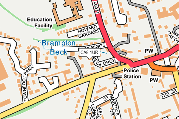
CA8 1UR lies on Beck Orchard in Brampton. CA8 1UR is located in the Brampton electoral ward, within the unitary authority of Cumberland and the English Parliamentary constituency of Penrith and The Border. The Sub Integrated Care Board (ICB) Location is NHS North East and North Cumbria ICB - 01H and the police force is Cumbria. This postcode has been in use since June 1996.


GetTheData
Source: OS OpenMap – Local (Ordnance Survey)
Source: OS VectorMap District (Ordnance Survey)
Licence: Open Government Licence (requires attribution)
| Easting | 352611 |
| Northing | 561071 |
| Latitude | 54.942037 |
| Longitude | -2.741267 |
GetTheData
Source: Open Postcode Geo
Licence: Open Government Licence
| Street | Beck Orchard |
| Town/City | Brampton |
| Country | England |
| Postcode District | CA8 |
➜ See where CA8 is on a map ➜ Where is Brampton? | |
GetTheData
Source: Land Registry Price Paid Data
Licence: Open Government Licence
Elevation or altitude of CA8 1UR as distance above sea level:
| Metres | Feet | |
|---|---|---|
| Elevation | 70m | 230ft |
Elevation is measured from the approximate centre of the postcode, to the nearest point on an OS contour line from OS Terrain 50, which has contour spacing of ten vertical metres.
➜ How high above sea level am I? Find the elevation of your current position using your device's GPS.
GetTheData
Source: Open Postcode Elevation
Licence: Open Government Licence
| Ward | Brampton |
| Constituency | Penrith And The Border |
GetTheData
Source: ONS Postcode Database
Licence: Open Government Licence
2, BECK ORCHARD, BRAMPTON, CA8 1UR 1996 28 FEB £85,000 |
GetTheData
Source: HM Land Registry Price Paid Data
Licence: Contains HM Land Registry data © Crown copyright and database right 2025. This data is licensed under the Open Government Licence v3.0.
| Police Station (Carlisle Road) | Brampton | 86m |
| Cox Lane (Carlisle Road) | Brampton | 99m |
| St Martin's Drive (Elmfield) | Brampton | 118m |
| St Martin's Drive (Elmfield) | Brampton | 188m |
| Shoulder Of Mutton (Front Street) | Brampton | 349m |
| Brampton (Cumbria) Station | 2.7km |
GetTheData
Source: NaPTAN
Licence: Open Government Licence
| Percentage of properties with Next Generation Access | 100.0% |
| Percentage of properties with Superfast Broadband | 100.0% |
| Percentage of properties with Ultrafast Broadband | 0.0% |
| Percentage of properties with Full Fibre Broadband | 0.0% |
Superfast Broadband is between 30Mbps and 300Mbps
Ultrafast Broadband is > 300Mbps
| Percentage of properties unable to receive 2Mbps | 0.0% |
| Percentage of properties unable to receive 5Mbps | 0.0% |
| Percentage of properties unable to receive 10Mbps | 0.0% |
| Percentage of properties unable to receive 30Mbps | 0.0% |
GetTheData
Source: Ofcom
Licence: Ofcom Terms of Use (requires attribution)
GetTheData
Source: ONS Postcode Database
Licence: Open Government Licence


➜ Get more ratings from the Food Standards Agency
GetTheData
Source: Food Standards Agency
Licence: FSA terms & conditions
| Last Collection | |||
|---|---|---|---|
| Location | Mon-Fri | Sat | Distance |
| Irthing Valley School | 17:30 | 12:45 | 187m |
| Townfoot | 17:30 | 12:45 | 355m |
| Irthing Walk | 17:30 | 13:00 | 372m |
GetTheData
Source: Dracos
Licence: Creative Commons Attribution-ShareAlike
| Risk of CA8 1UR flooding from rivers and sea | Medium |
| ➜ CA8 1UR flood map | |
GetTheData
Source: Open Flood Risk by Postcode
Licence: Open Government Licence
The below table lists the International Territorial Level (ITL) codes (formerly Nomenclature of Territorial Units for Statistics (NUTS) codes) and Local Administrative Units (LAU) codes for CA8 1UR:
| ITL 1 Code | Name |
|---|---|
| TLD | North West (England) |
| ITL 2 Code | Name |
| TLD1 | Cumbria |
| ITL 3 Code | Name |
| TLD12 | East Cumbria |
| LAU 1 Code | Name |
| E07000028 | Carlisle |
GetTheData
Source: ONS Postcode Directory
Licence: Open Government Licence
The below table lists the Census Output Area (OA), Lower Layer Super Output Area (LSOA), and Middle Layer Super Output Area (MSOA) for CA8 1UR:
| Code | Name | |
|---|---|---|
| OA | E00097038 | |
| LSOA | E01019201 | Carlisle 002B |
| MSOA | E02003988 | Carlisle 002 |
GetTheData
Source: ONS Postcode Directory
Licence: Open Government Licence
| CA8 1AL | Beck Riggs | 55m |
| CA8 1ST | Carlisle Road | 80m |
| CA8 1SR | Carlisle Road | 81m |
| CA8 1SS | Carlisle Road | 98m |
| CA8 1SJ | Longtown Road | 108m |
| CA8 1TQ | St Martins Drive | 111m |
| CA8 1AH | Howard Gardens | 120m |
| CA8 1SP | Townfoot Court | 123m |
| CA8 1SL | St Martins Terrace | 133m |
| CA8 1AN | Longtown Road | 134m |
GetTheData
Source: Open Postcode Geo; Land Registry Price Paid Data
Licence: Open Government Licence