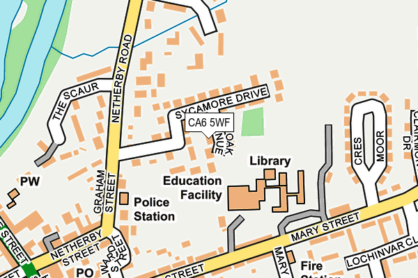
CA6 5WF lies on Oak Avenue in Longtown, Carlisle. CA6 5WF is located in the Longtown electoral ward, within the unitary authority of Cumberland and the English Parliamentary constituency of Penrith and The Border. The Sub Integrated Care Board (ICB) Location is NHS North East and North Cumbria ICB - 01H and the police force is Cumbria. This postcode has been in use since September 2014.


GetTheData
Source: OS OpenMap – Local (Ordnance Survey)
Source: OS VectorMap District (Ordnance Survey)
Licence: Open Government Licence (requires attribution)
| Easting | 338159 |
| Northing | 568932 |
| Latitude | 55.011083 |
| Longitude | -2.968528 |
GetTheData
Source: Open Postcode Geo
Licence: Open Government Licence
| Street | Oak Avenue |
| Locality | Longtown |
| Town/City | Carlisle |
| Country | England |
| Postcode District | CA6 |
➜ See where CA6 is on a map ➜ Where is Longtown? | |
GetTheData
Source: Land Registry Price Paid Data
Licence: Open Government Licence
Elevation or altitude of CA6 5WF as distance above sea level:
| Metres | Feet | |
|---|---|---|
| Elevation | 20m | 66ft |
Elevation is measured from the approximate centre of the postcode, to the nearest point on an OS contour line from OS Terrain 50, which has contour spacing of ten vertical metres.
➜ How high above sea level am I? Find the elevation of your current position using your device's GPS.
GetTheData
Source: Open Postcode Elevation
Licence: Open Government Licence
| Ward | Longtown |
| Constituency | Penrith And The Border |
GetTheData
Source: ONS Postcode Database
Licence: Open Government Licence
2021 28 MAY £162,500 |
2020 11 SEP £250,000 |
2017 10 NOV £150,000 |
2015 20 FEB £159,950 |
2014 16 DEC £249,950 |
2, OAK AVENUE, LONGTOWN, CARLISLE, CA6 5WF 2014 13 NOV £204,950 |
2014 7 NOV £249,950 |
2014 16 OCT £55,000 |
GetTheData
Source: HM Land Registry Price Paid Data
Licence: Contains HM Land Registry data © Crown copyright and database right 2025. This data is licensed under the Open Government Licence v3.0.
| Mary Street | Longtown | 170m |
| Swan Street | Longtown | 224m |
| Lochinvar School (Mary Street) | Longtown | 230m |
| Mary St (Mary Street) | Longtown | 260m |
| Dukeswood Road (Stackbraes Road) | Longtown | 328m |
GetTheData
Source: NaPTAN
Licence: Open Government Licence
| Percentage of properties with Next Generation Access | 100.0% |
| Percentage of properties with Superfast Broadband | 100.0% |
| Percentage of properties with Ultrafast Broadband | 0.0% |
| Percentage of properties with Full Fibre Broadband | 0.0% |
Superfast Broadband is between 30Mbps and 300Mbps
Ultrafast Broadband is > 300Mbps
| Median download speed | 20.5Mbps |
| Average download speed | 24.3Mbps |
| Maximum download speed | 40.00Mbps |
| Median upload speed | 1.1Mbps |
| Average upload speed | 2.4Mbps |
| Maximum upload speed | 7.89Mbps |
| Percentage of properties unable to receive 2Mbps | 0.0% |
| Percentage of properties unable to receive 5Mbps | 0.0% |
| Percentage of properties unable to receive 10Mbps | 0.0% |
| Percentage of properties unable to receive 30Mbps | 0.0% |
GetTheData
Source: Ofcom
Licence: Ofcom Terms of Use (requires attribution)
Estimated total energy consumption in CA6 5WF by fuel type, 2015.
| Consumption (kWh) | 60,419 |
|---|---|
| Meter count | 7 |
| Mean (kWh/meter) | 8,631 |
| Median (kWh/meter) | 8,143 |
GetTheData
Source: Postcode level gas estimates: 2015 (experimental)
Source: Postcode level electricity estimates: 2015 (experimental)
Licence: Open Government Licence
GetTheData
Source: ONS Postcode Database
Licence: Open Government Licence


➜ Get more ratings from the Food Standards Agency
GetTheData
Source: Food Standards Agency
Licence: FSA terms & conditions
| Last Collection | |||
|---|---|---|---|
| Location | Mon-Fri | Sat | Distance |
| Longtown | 17:30 | 12:00 | 267m |
| Moor Road | 17:00 | 11:00 | 367m |
| Arthured Drive | 17:15 | 09:15 | 655m |
GetTheData
Source: Dracos
Licence: Creative Commons Attribution-ShareAlike
The below table lists the International Territorial Level (ITL) codes (formerly Nomenclature of Territorial Units for Statistics (NUTS) codes) and Local Administrative Units (LAU) codes for CA6 5WF:
| ITL 1 Code | Name |
|---|---|
| TLD | North West (England) |
| ITL 2 Code | Name |
| TLD1 | Cumbria |
| ITL 3 Code | Name |
| TLD12 | East Cumbria |
| LAU 1 Code | Name |
| E07000028 | Carlisle |
GetTheData
Source: ONS Postcode Directory
Licence: Open Government Licence
The below table lists the Census Output Area (OA), Lower Layer Super Output Area (LSOA), and Middle Layer Super Output Area (MSOA) for CA6 5WF:
| Code | Name | |
|---|---|---|
| OA | E00097183 | |
| LSOA | E01019228 | Carlisle 001C |
| MSOA | E02003987 | Carlisle 001 |
GetTheData
Source: ONS Postcode Directory
Licence: Open Government Licence
| CA6 5WE | Beech Close | 57m |
| CA6 5NZ | Sycamore Drive | 62m |
| CA6 5UG | 129m | |
| CA6 5NT | Netherby Road | 154m |
| CA6 5NS | Netherby Road | 158m |
| CA6 5UF | Mary Street | 164m |
| CA6 5NR | Graham Street | 180m |
| CA6 5XD | Powdrake Crescent | 193m |
| CA6 5NU | The Scaur | 197m |
| CA6 5UZ | Swan Street | 197m |
GetTheData
Source: Open Postcode Geo; Land Registry Price Paid Data
Licence: Open Government Licence