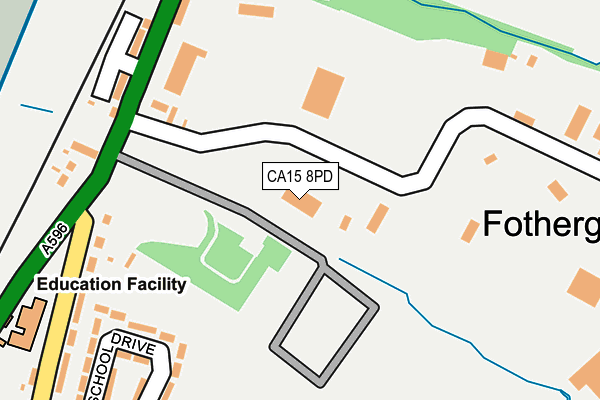
CA15 8PD lies on Risehow Industrial Estate in Flimby, Maryport. CA15 8PD is located in the Maryport South electoral ward, within the unitary authority of Cumberland and the English Parliamentary constituency of Workington. The Sub Integrated Care Board (ICB) Location is NHS North East and North Cumbria ICB - 01H and the police force is Cumbria. This postcode has been in use since January 1980.


GetTheData
Source: OS OpenMap – Local (Ordnance Survey)
Source: OS VectorMap District (Ordnance Survey)
Licence: Open Government Licence (requires attribution)
| Easting | 302637 |
| Northing | 534213 |
| Latitude | 54.693513 |
| Longitude | -3.512086 |
GetTheData
Source: Open Postcode Geo
Licence: Open Government Licence
| Street | Risehow Industrial Estate |
| Locality | Flimby |
| Town/City | Maryport |
| Country | England |
| Postcode District | CA15 |
➜ See where CA15 is on a map ➜ Where is Fothergill? | |
GetTheData
Source: Land Registry Price Paid Data
Licence: Open Government Licence
Elevation or altitude of CA15 8PD as distance above sea level:
| Metres | Feet | |
|---|---|---|
| Elevation | 10m | 33ft |
Elevation is measured from the approximate centre of the postcode, to the nearest point on an OS contour line from OS Terrain 50, which has contour spacing of ten vertical metres.
➜ How high above sea level am I? Find the elevation of your current position using your device's GPS.
GetTheData
Source: Open Postcode Elevation
Licence: Open Government Licence
| Ward | Maryport South |
| Constituency | Workington |
GetTheData
Source: ONS Postcode Database
Licence: Open Government Licence
| The Fothergills (A596) | Flimby | 270m |
| The Fothergills (A596) | Flimby | 307m |
| School (A596) | Flimby | 346m |
| School (A596) | Flimby | 353m |
| Risehow (A596) | Risehow | 661m |
| Flimby Station | 0.7km |
| Maryport Station | 2.3km |
GetTheData
Source: NaPTAN
Licence: Open Government Licence
GetTheData
Source: ONS Postcode Database
Licence: Open Government Licence


➜ Get more ratings from the Food Standards Agency
GetTheData
Source: Food Standards Agency
Licence: FSA terms & conditions
| Last Collection | |||
|---|---|---|---|
| Location | Mon-Fri | Sat | Distance |
| Fothergill | 16:15 | 09:30 | 284m |
| Eagle Terrace | 16:30 | 10:30 | 393m |
| Flimby | 16:15 | 10:30 | 656m |
GetTheData
Source: Dracos
Licence: Creative Commons Attribution-ShareAlike
The below table lists the International Territorial Level (ITL) codes (formerly Nomenclature of Territorial Units for Statistics (NUTS) codes) and Local Administrative Units (LAU) codes for CA15 8PD:
| ITL 1 Code | Name |
|---|---|
| TLD | North West (England) |
| ITL 2 Code | Name |
| TLD1 | Cumbria |
| ITL 3 Code | Name |
| TLD11 | West Cumbria |
| LAU 1 Code | Name |
| E07000026 | Allerdale |
GetTheData
Source: ONS Postcode Directory
Licence: Open Government Licence
The below table lists the Census Output Area (OA), Lower Layer Super Output Area (LSOA), and Middle Layer Super Output Area (MSOA) for CA15 8PD:
| Code | Name | |
|---|---|---|
| OA | E00096529 | |
| LSOA | E01019099 | Allerdale 005D |
| MSOA | E02003969 | Allerdale 005 |
GetTheData
Source: ONS Postcode Directory
Licence: Open Government Licence
| CA15 8PB | Main Road | 291m |
| CA15 8PG | The Fothergills | 295m |
| CA15 8PL | School Drive | 321m |
| CA15 8PJ | Rye Hill Road | 339m |
| CA15 8PF | Miller Place | 413m |
| CA15 8TS | Pennygill | 424m |
| CA15 8PQ | Farmers Way | 440m |
| CA15 8PW | Rye Hill Road | 460m |
| CA15 8PT | Andersons Court | 467m |
| CA15 8TP | Lonsdale Place | 486m |
GetTheData
Source: Open Postcode Geo; Land Registry Price Paid Data
Licence: Open Government Licence