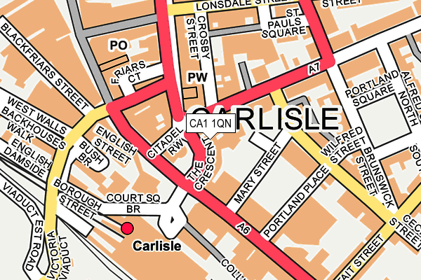
CA1 1QN lies on The Crescent in Carlisle. CA1 1QN is located in the Castle electoral ward, within the unitary authority of Cumberland and the English Parliamentary constituency of Carlisle. The Sub Integrated Care Board (ICB) Location is NHS North East and North Cumbria ICB - 01H and the police force is Cumbria. This postcode has been in use since January 1980.


GetTheData
Source: OS OpenMap – Local (Ordnance Survey)
Source: OS VectorMap District (Ordnance Survey)
Licence: Open Government Licence (requires attribution)
| Easting | 340304 |
| Northing | 555677 |
| Latitude | 54.892255 |
| Longitude | -2.932234 |
GetTheData
Source: Open Postcode Geo
Licence: Open Government Licence
| Street | The Crescent |
| Town/City | Carlisle |
| Country | England |
| Postcode District | CA1 |
➜ See where CA1 is on a map ➜ Where is Carlisle? | |
GetTheData
Source: Land Registry Price Paid Data
Licence: Open Government Licence
Elevation or altitude of CA1 1QN as distance above sea level:
| Metres | Feet | |
|---|---|---|
| Elevation | 20m | 66ft |
Elevation is measured from the approximate centre of the postcode, to the nearest point on an OS contour line from OS Terrain 50, which has contour spacing of ten vertical metres.
➜ How high above sea level am I? Find the elevation of your current position using your device's GPS.
GetTheData
Source: Open Postcode Elevation
Licence: Open Government Licence
| Ward | Castle |
| Constituency | Carlisle |
GetTheData
Source: ONS Postcode Database
Licence: Open Government Licence
| Irvings Travel Shop (The Crescent) | Carlisle | 12m |
| La Mexxaluna (The Crescent) | Carlisle | 22m |
| Halston Hotel (Warwick Road) | Carlisle | 55m |
| The Courts (English Street) | Carlisle | 82m |
| The Courts (English Street) | Carlisle | 91m |
| Carlisle Station | 0.2km |
GetTheData
Source: NaPTAN
Licence: Open Government Licence
GetTheData
Source: ONS Postcode Database
Licence: Open Government Licence


➜ Get more ratings from the Food Standards Agency
GetTheData
Source: Food Standards Agency
Licence: FSA terms & conditions
| Last Collection | |||
|---|---|---|---|
| Location | Mon-Fri | Sat | Distance |
| Head Post Office | 19:15 | 15:45 | 103m |
| Warwick Road | 18:30 | 12:30 | 107m |
| English Street | 19:20 | 14:45 | 139m |
GetTheData
Source: Dracos
Licence: Creative Commons Attribution-ShareAlike
The below table lists the International Territorial Level (ITL) codes (formerly Nomenclature of Territorial Units for Statistics (NUTS) codes) and Local Administrative Units (LAU) codes for CA1 1QN:
| ITL 1 Code | Name |
|---|---|
| TLD | North West (England) |
| ITL 2 Code | Name |
| TLD1 | Cumbria |
| ITL 3 Code | Name |
| TLD12 | East Cumbria |
| LAU 1 Code | Name |
| E07000028 | Carlisle |
GetTheData
Source: ONS Postcode Directory
Licence: Open Government Licence
The below table lists the Census Output Area (OA), Lower Layer Super Output Area (LSOA), and Middle Layer Super Output Area (MSOA) for CA1 1QN:
| Code | Name | |
|---|---|---|
| OA | E00097059 | |
| LSOA | E01019206 | Carlisle 006B |
| MSOA | E02003992 | Carlisle 006 |
GetTheData
Source: ONS Postcode Directory
Licence: Open Government Licence
| CA1 1QW | The Crescent | 35m |
| CA1 1QP | Botchergate | 60m |
| CA1 1DH | Warwick Road | 71m |
| CA1 1DN | Warwick Road | 74m |
| CA3 8ES | Lowther Street | 85m |
| CA3 8LX | Lowther Arcade | 100m |
| CA1 1DP | Earl Street | 103m |
| CA1 1DQ | Crosby Street | 104m |
| CA3 8DA | Lowther Street | 124m |
| CA1 1NL | Cecil Street | 132m |
GetTheData
Source: Open Postcode Geo; Land Registry Price Paid Data
Licence: Open Government Licence