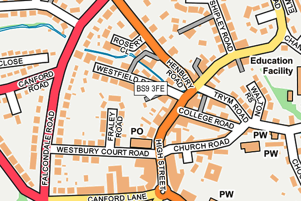
BS9 3FE is located in the Westbury-on-Trym and Henleaze electoral ward, within the unitary authority of Bristol, City of and the English Parliamentary constituency of Bristol North West. The Sub Integrated Care Board (ICB) Location is NHS Bristol, North Somerset and South Gloucestershire ICB - 15C and the police force is Avon and Somerset. This postcode has been in use since March 2017.


GetTheData
Source: OS OpenMap – Local (Ordnance Survey)
Source: OS VectorMap District (Ordnance Survey)
Licence: Open Government Licence (requires attribution)
| Easting | 357154 |
| Northing | 177503 |
| Latitude | 51.494834 |
| Longitude | -2.618573 |
GetTheData
Source: Open Postcode Geo
Licence: Open Government Licence
| Country | England |
| Postcode District | BS9 |
➜ See where BS9 is on a map ➜ Where is Bristol? | |
GetTheData
Source: Land Registry Price Paid Data
Licence: Open Government Licence
| Ward | Westbury-on-trym And Henleaze |
| Constituency | Bristol North West |
GetTheData
Source: ONS Postcode Database
Licence: Open Government Licence
| Westbury High Street | Westbury On Trym | 141m |
| Henbury Road C (Henbury Road) | Westbury On Trym | 173m |
| Henbury Road (Falcondale Road) | Westbury On Trym | 216m |
| Westbury Village (Canford Lane) | Westbury On Trym | 230m |
| Westbury Village | Westbury On Trym | 232m |
| Sea Mills Station | 2.7km |
| Redland Station | 3.2km |
| Clifton Down Station | 3.4km |
GetTheData
Source: NaPTAN
Licence: Open Government Licence
| Percentage of properties with Next Generation Access | 0.0% |
| Percentage of properties with Superfast Broadband | 0.0% |
| Percentage of properties with Ultrafast Broadband | 0.0% |
| Percentage of properties with Full Fibre Broadband | 0.0% |
Superfast Broadband is between 30Mbps and 300Mbps
Ultrafast Broadband is > 300Mbps
| Percentage of properties unable to receive 2Mbps | 0.0% |
| Percentage of properties unable to receive 5Mbps | 0.0% |
| Percentage of properties unable to receive 10Mbps | 0.0% |
| Percentage of properties unable to receive 30Mbps | 100.0% |
GetTheData
Source: Ofcom
Licence: Ofcom Terms of Use (requires attribution)
GetTheData
Source: ONS Postcode Database
Licence: Open Government Licence


➜ Get more ratings from the Food Standards Agency
GetTheData
Source: Food Standards Agency
Licence: FSA terms & conditions
| Last Collection | |||
|---|---|---|---|
| Location | Mon-Fri | Sat | Distance |
| Westbury On Trym Post Office | 18:00 | 11:30 | 103m |
| Westbury On Trym Post Office | 18:00 | 11:30 | 105m |
| Henbury Road | 16:00 | 12:00 | 182m |
GetTheData
Source: Dracos
Licence: Creative Commons Attribution-ShareAlike
The below table lists the International Territorial Level (ITL) codes (formerly Nomenclature of Territorial Units for Statistics (NUTS) codes) and Local Administrative Units (LAU) codes for BS9 3FE:
| ITL 1 Code | Name |
|---|---|
| TLK | South West (England) |
| ITL 2 Code | Name |
| TLK1 | Gloucestershire, Wiltshire and Bath/Bristol area |
| ITL 3 Code | Name |
| TLK11 | Bristol, City of |
| LAU 1 Code | Name |
| E06000023 | Bristol, City of |
GetTheData
Source: ONS Postcode Directory
Licence: Open Government Licence
The below table lists the Census Output Area (OA), Lower Layer Super Output Area (LSOA), and Middle Layer Super Output Area (MSOA) for BS9 3FE:
| Code | Name | |
|---|---|---|
| OA | E00074349 | |
| LSOA | E01014719 | Bristol 006B |
| MSOA | E02003017 | Bristol 006 |
GetTheData
Source: ONS Postcode Directory
Licence: Open Government Licence
| BS9 3ED | High Street | 30m |
| BS9 3HH | Westfield Road | 51m |
| BS9 3DZ | High Street | 51m |
| BS9 3EH | College Mews | 74m |
| BS9 3HQ | Henbury Road | 76m |
| BS9 3HG | Westfield Road | 87m |
| BS9 3HJ | Henbury Road | 92m |
| BS9 3HW | Watkins Yard | 104m |
| BS9 3HN | Passage Road | 109m |
| BS9 3EJ | College Road | 115m |
GetTheData
Source: Open Postcode Geo; Land Registry Price Paid Data
Licence: Open Government Licence