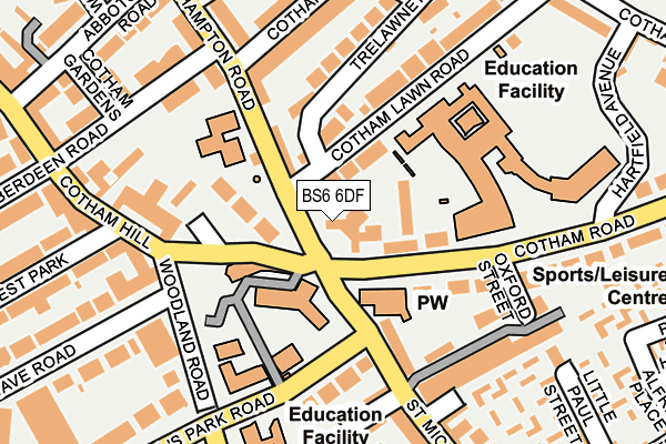
BS6 6DF is located in the Cotham electoral ward, within the unitary authority of Bristol, City of and the English Parliamentary constituency of Bristol West. The Sub Integrated Care Board (ICB) Location is NHS Bristol, North Somerset and South Gloucestershire ICB - 15C and the police force is Avon and Somerset. This postcode has been in use since May 1994.


GetTheData
Source: OS OpenMap – Local (Ordnance Survey)
Source: OS VectorMap District (Ordnance Survey)
Licence: Open Government Licence (requires attribution)
| Easting | 358180 |
| Northing | 173921 |
| Latitude | 51.462707 |
| Longitude | -2.603367 |
GetTheData
Source: Open Postcode Geo
Licence: Open Government Licence
| Country | England |
| Postcode District | BS6 |
➜ See where BS6 is on a map ➜ Where is Bristol? | |
GetTheData
Source: Land Registry Price Paid Data
Licence: Open Government Licence
Elevation or altitude of BS6 6DF as distance above sea level:
| Metres | Feet | |
|---|---|---|
| Elevation | 70m | 230ft |
Elevation is measured from the approximate centre of the postcode, to the nearest point on an OS contour line from OS Terrain 50, which has contour spacing of ten vertical metres.
➜ How high above sea level am I? Find the elevation of your current position using your device's GPS.
GetTheData
Source: Open Postcode Elevation
Licence: Open Government Licence
| Ward | Cotham |
| Constituency | Bristol West |
GetTheData
Source: ONS Postcode Database
Licence: Open Government Licence
| Cotham Hill (Cotham Road) | Cotham | 64m |
| Cotham Hill (Cotham Road) | Cotham | 71m |
| Cotham Hill (St Michael's Hill) | Cotham | 101m |
| Myrtle Road (Saint Michael's Hill) | Kingsdown | 288m |
| Myrtle Road (Saint Michael's Hill) | Kingsdown | 365m |
| Clifton Down Station | 0.6km |
| Redland Station | 0.7km |
| Montpelier Station | 1.2km |
GetTheData
Source: NaPTAN
Licence: Open Government Licence
GetTheData
Source: ONS Postcode Database
Licence: Open Government Licence


➜ Get more ratings from the Food Standards Agency
GetTheData
Source: Food Standards Agency
Licence: FSA terms & conditions
| Last Collection | |||
|---|---|---|---|
| Location | Mon-Fri | Sat | Distance |
| Trelawney Road | 17:30 | 12:15 | 58m |
| Cotham Hill | 17:30 | 12:30 | 158m |
| St Michaels Hill Post Office | 17:45 | 12:45 | 191m |
GetTheData
Source: Dracos
Licence: Creative Commons Attribution-ShareAlike
The below table lists the International Territorial Level (ITL) codes (formerly Nomenclature of Territorial Units for Statistics (NUTS) codes) and Local Administrative Units (LAU) codes for BS6 6DF:
| ITL 1 Code | Name |
|---|---|
| TLK | South West (England) |
| ITL 2 Code | Name |
| TLK1 | Gloucestershire, Wiltshire and Bath/Bristol area |
| ITL 3 Code | Name |
| TLK11 | Bristol, City of |
| LAU 1 Code | Name |
| E06000023 | Bristol, City of |
GetTheData
Source: ONS Postcode Directory
Licence: Open Government Licence
The below table lists the Census Output Area (OA), Lower Layer Super Output Area (LSOA), and Middle Layer Super Output Area (MSOA) for BS6 6DF:
| Code | Name | |
|---|---|---|
| OA | E00073528 | |
| LSOA | E01014558 | Bristol 022B |
| MSOA | E02003033 | Bristol 022 |
GetTheData
Source: ONS Postcode Directory
Licence: Open Government Licence
| BS6 6DG | Cotham Road | 55m |
| BS6 6QR | Cotham Place | 67m |
| BS6 6QS | Cotham Place | 67m |
| BS6 6DQ | Cotham Road | 68m |
| BS6 6DS | Cotham Lawn Road | 75m |
| BS6 6JP | Hillside | 77m |
| BS6 6EA | Trelawney Road | 90m |
| BS2 8DE | St Michaels Hill | 127m |
| BS6 6HJ | Hampton Road | 137m |
| BS8 1PW | Tyndalls Park Road | 141m |
GetTheData
Source: Open Postcode Geo; Land Registry Price Paid Data
Licence: Open Government Licence