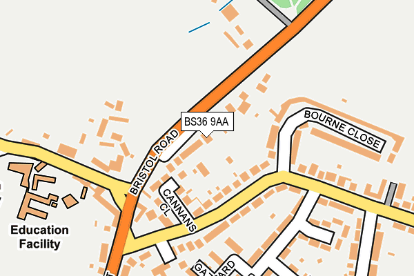
BS36 9AA is located in the Winterbourne electoral ward, within the unitary authority of South Gloucestershire and the English Parliamentary constituency of Filton and Bradley Stoke. The Sub Integrated Care Board (ICB) Location is NHS Bristol, North Somerset and South Gloucestershire ICB - 15C and the police force is Avon and Somerset. This postcode has been in use since August 2008.


GetTheData
Source: OS OpenMap – Local (Ordnance Survey)
Source: OS VectorMap District (Ordnance Survey)
Licence: Open Government Licence (requires attribution)
| Easting | 365296 |
| Northing | 181396 |
| Latitude | 51.530398 |
| Longitude | -2.501679 |
GetTheData
Source: Open Postcode Geo
Licence: Open Government Licence
| Country | England |
| Postcode District | BS36 |
➜ See where BS36 is on a map ➜ Where is Winterbourne? | |
GetTheData
Source: Land Registry Price Paid Data
Licence: Open Government Licence
Elevation or altitude of BS36 9AA as distance above sea level:
| Metres | Feet | |
|---|---|---|
| Elevation | 60m | 197ft |
Elevation is measured from the approximate centre of the postcode, to the nearest point on an OS contour line from OS Terrain 50, which has contour spacing of ten vertical metres.
➜ How high above sea level am I? Find the elevation of your current position using your device's GPS.
GetTheData
Source: Open Postcode Elevation
Licence: Open Government Licence
| Ward | Winterbourne |
| Constituency | Filton And Bradley Stoke |
GetTheData
Source: ONS Postcode Database
Licence: Open Government Licence
| The Swan (High Street) | Winterbourne | 189m |
| The Swan (High Street) | Winterbourne | 200m |
| North Road (Watleys End Road) | Winterbourne | 283m |
| North Road (Watley's End Road) | Winterbourne | 288m |
| Park Avenue | Winterbourne | 407m |
| Bristol Parkway Station | 3.4km |
| Patchway Station | 4.3km |
| Yate Station | 4.9km |
GetTheData
Source: NaPTAN
Licence: Open Government Licence
GetTheData
Source: ONS Postcode Database
Licence: Open Government Licence


➜ Get more ratings from the Food Standards Agency
GetTheData
Source: Food Standards Agency
Licence: FSA terms & conditions
| Last Collection | |||
|---|---|---|---|
| Location | Mon-Fri | Sat | Distance |
| Watleys End | 16:45 | 08:00 | 305m |
| High Street | 16:45 | 09:45 | 416m |
| St Francis Drive | 16:30 | 09:15 | 418m |
GetTheData
Source: Dracos
Licence: Creative Commons Attribution-ShareAlike
The below table lists the International Territorial Level (ITL) codes (formerly Nomenclature of Territorial Units for Statistics (NUTS) codes) and Local Administrative Units (LAU) codes for BS36 9AA:
| ITL 1 Code | Name |
|---|---|
| TLK | South West (England) |
| ITL 2 Code | Name |
| TLK1 | Gloucestershire, Wiltshire and Bath/Bristol area |
| ITL 3 Code | Name |
| TLK12 | Bath and North East Somerset, North Somerset and South Gloucestershire |
| LAU 1 Code | Name |
| E06000025 | South Gloucestershire |
GetTheData
Source: ONS Postcode Directory
Licence: Open Government Licence
The below table lists the Census Output Area (OA), Lower Layer Super Output Area (LSOA), and Middle Layer Super Output Area (MSOA) for BS36 9AA:
| Code | Name | |
|---|---|---|
| OA | E00075776 | |
| LSOA | E01014998 | South Gloucestershire 016A |
| MSOA | E02003105 | South Gloucestershire 016 |
GetTheData
Source: ONS Postcode Directory
Licence: Open Government Licence
| BS36 1RG | Bristol Road | 24m |
| BS36 1PH | Watleys End Road | 80m |
| BS36 1PG | Cannans Close | 84m |
| BS36 1PQ | Watleys End Road | 125m |
| BS36 1RF | High Street | 138m |
| BS36 1RQ | Bristol Road | 163m |
| BS36 1NW | Starbarn Road | 166m |
| BS36 1NR | Gazzard Road | 176m |
| BS36 1PJ | Bourne Close | 187m |
| BS36 1PL | Bourne Close | 188m |
GetTheData
Source: Open Postcode Geo; Land Registry Price Paid Data
Licence: Open Government Licence